Significant Rain and Wind Event Possible Early Next Week

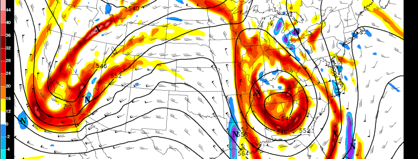
While most of the weather interest this time of year revolves around snowstorms, we are simply not in a pattern favorable for any in the next ten days or so. Instead, we have a very fast, active Pacific Jet with a plethora of disturbances running into the West Coast. Any one of these can theoretically bring rain to our area as they traverse the country, but that is largely dependent on the pattern downstream. As we head into this weekend, the pattern will become very “blocked up”, which means that any storm that moves east will be forced to slow down and amplify before it has any chance to move north and eastward towards our area. Essentially, the Pacific Jet serves as a highway, and the blocking pattern serves as a traffic jam that forces everything to slow down. When several shortwaves are forced to slow down, the traffic increases and backs up more with time, which forces the slowing down to move much further southwest with time. This means that several potent shortwaves are forced to interact with each other well to our southwest and turn into a monster storm system that has to slow down, and tap into plenty of Gulf of Mexico moisture.

Read more

PM Zone 7/8 Mesoscale Update: Winter weather tonight

As discussed in updates for the past few days, a winter weather event is expected to unfold tonight across parts of Southern New England. This will be particularly true in parts of Eastern New York and Northern Connecticut, where we are anticipating the potential for freezing rain and sleet tonight into Wednesday morning. Short term forecast models continue to indicate low level cold air remaining stout in these areas, resulting in concern for slick roads and hazardous travel.

Multiple rounds of precipitation are expected through tonight. Regional analysis showed a low pressure system and associated mid level lows (in the middle layers of the atmosphere) over the Eastern Great Lakes. This is pumping south/southwesterly winds into the area and warming up these atmospheric layers. Therefore, most areas are experiencing plain rain. The surface and low level atmosphere temperature in the high elevations of Eastern NY and CT, however, is colder, allowing for sleet and freezing rain.

Read more

1/17 Zones 7 & 8 Update on Ice Threat over Far Northern Interior Areas Today

Low pressure system is currently over the Ohio Valley this morning. As it tracks northeast into the Eastern Great Lakes, it will cause a warm front to approach the region. Areas of light precipitation, have been gradually developing over the region this morning. Warmer air has already moved into the lower and mid-levels of the atmosphere. of So many locations are just seeing rain today.

However, some colder, dry air near the surface and lower levels may be harder to scour out for some higher elevations just north of I-84, and over Northwest CT, This lead some areas patchy light freezing rain that could be mixed some with snow or sleet. No substantial snow accumulations are anticipated. But some slippery travel conditions are possible with a light glaze of ice on roads and sidewalks.

Read more

1/17 ALL AM Zones Update: Unsettled Weather Through Wednesday

Low pressure system will tracking from Ohio Valley to the Eastern Great Lakes, will cause a warm front to approach the region. Lift from warm-air advection ahead of this front will cause periods of light rain to develop during the midday hours. Then rain will become steadier and perhaps moderate to heavy times later this afternoon, as more lift and moisture increase along the warm front and a secondary low develops south of Long Island. But not enough rain is anticipated to cause any significant flooding hazards.

Read more