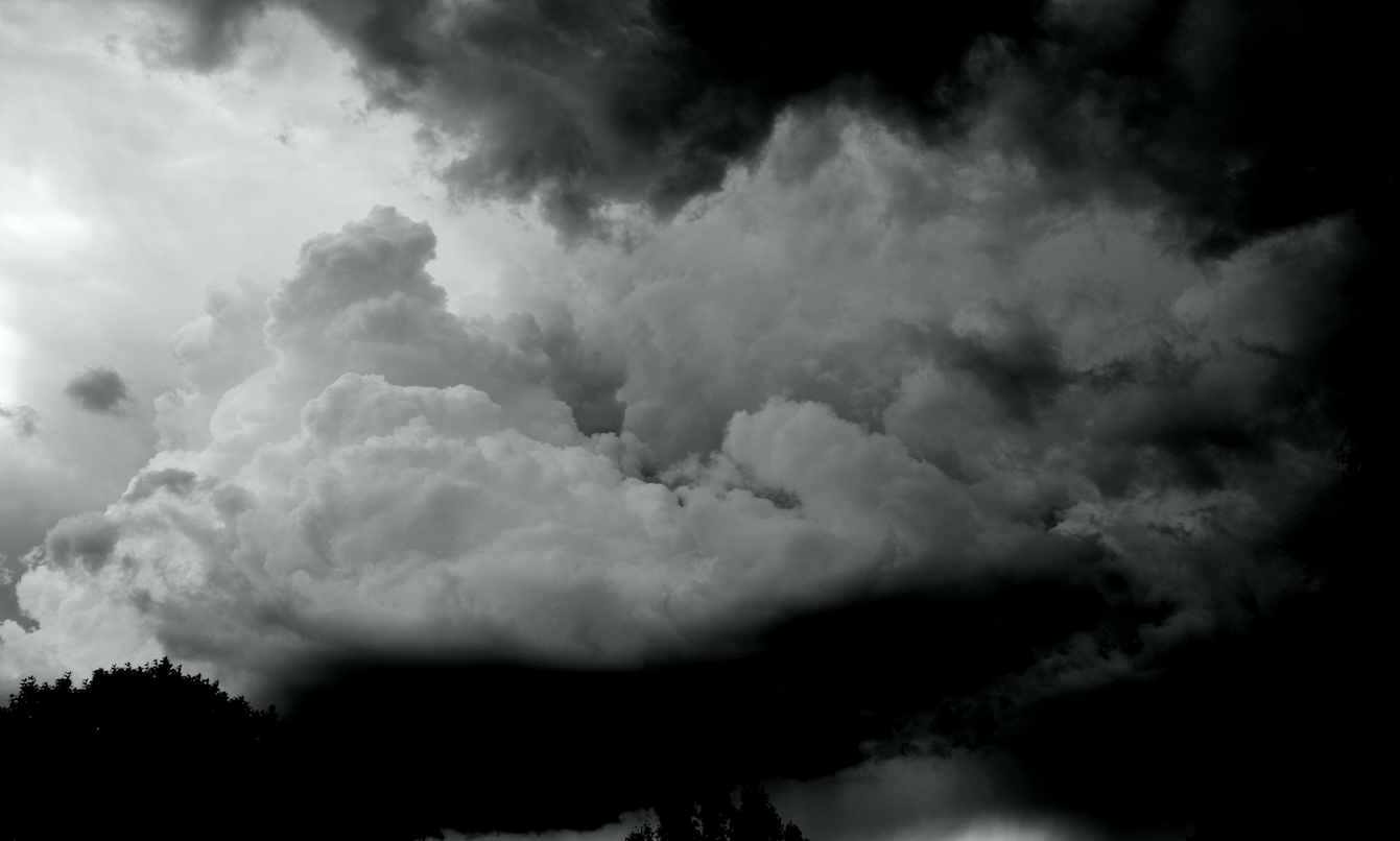
Each year, as the atmospheric pattern begins to undergo a transition and wavelengths begin to change, the threat for strong to severe thunderstorms becomes a focus of the meteorological community in the Northeast. Spring, in fact, marks the beginning of “Severe Weather” season in our area — which generally has been known to begin on May 1st. There are obviously severe thunderstorm events outside of that date, but in general the most consistent potential for organized severe storms begins in May and ends in August or September.
Interestingly enough, severe thunderstorms feature some terminology and atmospheric interactions which can be very confusing not only to interpret as meteorologists, but to understand on the public level. Knowing the basics of how organized thunderstorm events develop, and how forecasters attempt to predict and quantify their potential, will help to make things a little less confusing when severe weather season comes around this year.
What typically causes thunderstorms to form in the Northeast?
Despite being directly next to a body of water, the general rules for organized thunderstorms remain the same in our area as they are across much of the United States. Organized thunderstorms events occur when there is sufficient instability, enough lift or forcing in the atmosphere to trigger storm development, and favorable wind fields or shear to keep the storms organized. Essentially, thunderstorms form as a result of “convection”. Usually created by surface heating, convection is upward atmospheric motion that transports whatever is in the air along with it—especially any moisture available in the air.
The process by which organized thunderstorm events occur can be broken down despite being extremely complicated on a case-by-case basis. First, the sun needs to heat the surface to warm the air above it. When this warm surface air is forced to rise (a front, mountains, a sea breeze boundary, etc) it will continue to rise so long as it stays warmer than the air surrounding it.
The process thereafter becomes a bit more complicated. As a storm rises into freezing air, different types of ice particles can be created from freezing liquid drops. The ice particles can grow by condensing vapor (like frost) and by collecting smaller liquid drops that haven’t frozen yet (a state called “supercooled”). When two ice particles collide, they usually bounce off each other, but one particle can rip off a little bit of ice from the other one and grab some electric charge. Lots of these collisions build up big regions of electric charges to cause a bolt of lightning, which creates the sound waves we hear as thunder. (National Weather Service).
What is the typical life cycle of a thunderstorm?
So, we’ve formed the thunderstorm. Now, the thunderstorm will go through stages, or a life cycle. While the duration of each stage will vary depending on the atmospheric setup, each storm goes through these stages eventually: A developing stage, a mature stage, and a dissipating stage.
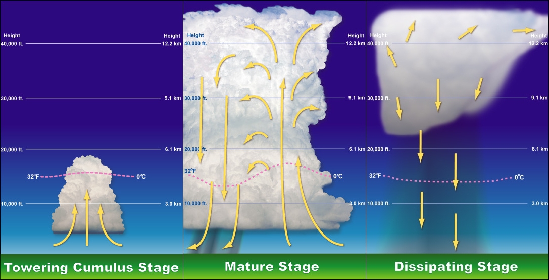
Lifecycle of a thunderstorm, via wikipedia.
As the National Weather Service puts it, The developing stage of a thunderstorm is marked by a cumulus cloud that is being pushed upward by a rising column of air (updraft). The cumulus cloud soon looks like a tower (called towering cumulus) as the updraft continues to develop. There is little to no rain during this stage but occasional lightning. The thunderstorm enters the mature stage when the updraft continues to feed the storm, but precipitation begins to fall out of the storm, creating a downdraft (a column of air pushing downward). When the downdraft and rain-cooled air spreads out along the ground it forms a gust front, or a line of gusty winds.
The mature stage is the most likely time for hail, heavy rain, frequent lightning, strong winds, and tornadoes. Eventually, a large amount of precipitation is produced and the updraft is overcome by the downdraft beginning the dissipating stage. At the ground, the gust front moves out a long distance from the storm and cuts off the warm moist air that was feeding the thunderstorm. Rainfall decreases in intensity, but lightning remains a danger.
What makes a thunderstorm severe?
Very simply, a thunderstorm is classified as “severe” when it contains one or more of the following: hail one inch or greater, winds gusting in excess of 50 knots (57.5 mph), or a tornado. The National Weather Service defines severe thunderstorms strictly by this criteria. That being said, in our area, thunderstorms are often not severe. They can still feature major impacts, such as frequent and dangerous lightning and heavy rain, but don’t meet severe thunderstorm criteria.
How can severe thunderstorm events vary?
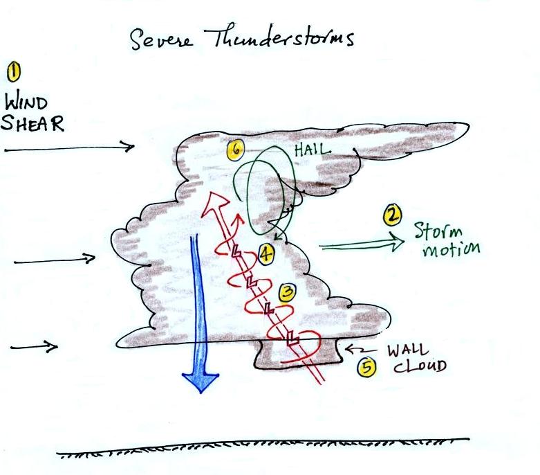
A hand drawing of an “ideal” supercell thunderstorm formation. (Arizona U)
Varying amounts of wind shear, instability, and lift can generate all different types of thunderstorms and thunderstorm events. For instance, an environment with lots of instability but very little shear will lead to quick development of updrafts. However, the lack of shear will cause the storms to have little motion or movement. So the updraft will form, and essentially “use up” all of instability — and eventually collapse on top of itself and dissipate. This is often the case during the “popcorn” thunderstorms which form during the summer.
What is the Storm Prediction Center, and what are watches and warnings?
This is the magic question and the center of an entire universe of confusion. So lets clear it up.
The Storm Prediction Center is a division of the National Weather Service. It is staffed by experts in the prediction of thunderstorms and organized convective events. The Storm Prediction Center issues thunderstorm outlooks for the entire country for Day 1 (today), Day 2 (tomorrow), and Day 3 (the day after tomorrow). They also issue extended outlooks which highlight potential widespread storm events 4 to 7 days in advance.
The Day 1, 2 and 3 outlooks from the Storm Prediction Center feature risk areas, or categories of risk for severe thunderstorms: Marginal, Slight, Enhanced, Moderate and High. But these categories are not just simply imagined — they are triggered by probabilities of severe thunderstorms within a certain distance of a point. So, for instance, if the forecasters at SPC agree that there is a 15% chance of damaging winds from thunderstorms in a certain area, that area will be placed under a “Slight Risk”. The risk areas can be triggered by the potential for Tornadoes, Hail, or Wind. For a breakdown, click here.
You can access the Storm Prediction Center’s daily outlooks here.
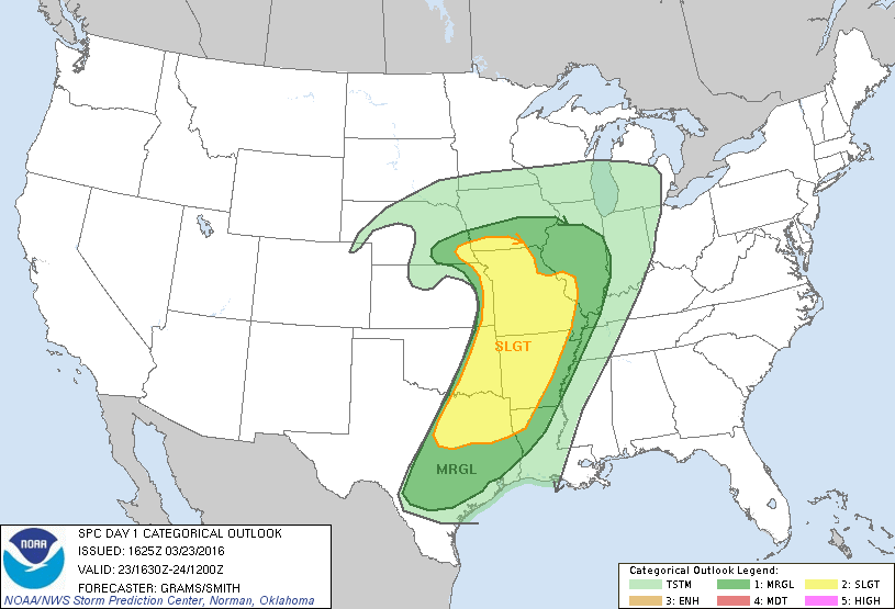
An example outlook from the SPC showing Marginal and Slight Risk areas over the Central US.
The lowdown on watches and warnings…
Severe Thunderstorm Watch: A severe thunderstorm watch (also referred to as a blue box, or sva by meteorologists) is issued when forecasters at the National Weather Service believe that conditions are favorable for the development of organized severe thunderstorms — which are capable of producing winds or hail of severe criteria. This does not mean that your area is guaranteed to get a severe thunderstorm watch; rather that your area is included in a broad brushed potential focus area for severe weather.
Tornado Watch: A tornado watch (also referred to as a red box, or tw by meteorologists) is issued when meteorologists at the National Weather Service believe that conditions are favorable for the development of organized severe thunderstorms which are capable of producing tornadoes. Similarly to a severe thunderstorm watch, this watch is meant to inform the area included that they are in a focus area for potential thunderstorms capable of producing tornadoes.
Severe Thunderstorm Warning: A severe thunderstorm warning is issued by the National Weather Service when a thunderstorm is imminent, and is likely to produce conditions which will meet criteria for a severe thunderstorm. This means that either large hail or strong winds are likely, and capable of producing significant damage. During a severe thunderstorm warning, get or remain indoors and stay away from windows and doors.
Tornado Warning: A tornado warning is issued by the National Weather Service when meteorologists or trained weather spotters have observed, or detected via Doppler radar, an occurring or imminent tornado touchdown. It can be issued after a tornado or funnel cloud has been spotted by eye, or more commonly if there are radar indications of tornado formation. When a tornado warning is issued, regardless of the weather outside, you should immediately go to a shelter. View recommended shelters here.
Should we expect a lot of severe thunderstorms this year?
The most interesting aspect of severe thunderstorm season is that it is still somewhat unpredictable. Meteorologists can predict the likelihood of storm systems (we’re expecting a more active spring this year) which could cause thunderstorms. But the more intricate details, including the presence of clouds, a sea breeze, or exact wind shear — aren’t known until the day before the event. So the number of severe thunderstorm events per season is hard to predict.
Since the early to mid 2000’s, our area has generally seen less organized severe thunderstorm events. But that’s not to say we can’t see a more active season this year. Severe thunderstorms in our area are a fickle thing. We have the mountains to our west, and the cooler ocean waters to our east. And so typically, the window for organized severe weather is small. Still, organized events with sufficient wind shear and favorable setups aloft can sometimes bring impressive, widespread severe weather through our area. We’ll be monitoring closely as we approach May 1st, and hopefully you’ll be able to reference this page for more information as we start posting and talking about the meteorology behind each individual event this spring.
Still have questions? Shoot us an email, or drop us a message on Twitter or Facebook and we’ll answer your question and even add it to the page. Knowledge is power!
-2")
