3/15 All Zones Noon Update: Snow Showers Today…Wintry Mix Possible Friday Night into Saturday

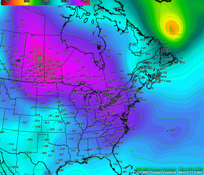
After the big winter storm and Nor’easter yesterday, that brought 1 to 2 feet of snow to Interior, and more wintry mix to the coast, some what calmer weather returns for few days. Deep surface low pressure will continue to move north into Southeast Canada. Behind it are drier northwesterly winds, which will lead to clouds mixing with sunshine this afternoon withcold and blustery conditions. High temperatures this afternoon will reach into the upper 20s to lower 30s for most of the region.

Read more

3/13 Evening Zones Update: Blizzard with High Winds and Coastal Flooding Tuesday

While many people focused on blizzard with very heavy snowfall, there will other important hazards that come with this storm. The blizzard will also be a major Nor’easter with strong winds, especially closer to the coast, tomorrow morning and early afternoon. There will be tight thermal gradient between deep low off Delmarva coast and high over Southeast Canada. This will  will east to northeast winds sustained at least between 20-30 mph with frequent gusts up to 40 mph over much of the region. But there potential for even much higher gusts with strong easterly 850mb-950mb jet moving through the region.

Read more

Blizzard 2017 Storm Overview, Hazards, and Preparation

Good afternoon! It is becoming more clear by the hour that a major winter storm with blizzard conditions will be impacting the area late in the overnight and into Tuesday. Extreme snowfall rates — 2 to 5″ per hour — are possible on Tuesday morning, as well as wind gusts up to 50mph. This will dramatically reduce visibilities below 1/4th and even below 1/8th of a mile or lower at times. This may also lead to some power outages, so be sure to be prepared with flashlights, batteries, a full tank of gasoline, and charged phones.

The storm has trended slightly warmer for coastal locations, with faster timing — but stronger dynamics away from the immediate coast has elevated the potential for extremely heavy snow and severe impacts. Even coastal areas will still see very heavy snow before a quicker changeover to sleet and rain — but less snow than inland areas. This video below has all of the details regarding the storm’s evolution, impacts, and meteorological explanation behind why the snow will be so heavy. Stay tuned for further updates!

3/12 PM All Zones Update: High-Impact Blizzard Likely Tuesday Into Wednesday

Today has been what some may call the “calm before the storm”, as the day has been characterized by mostly sunny conditions across the entire area with temperatures only in the upper 20’s to low 30’s, which is below normal for this time of year. We have also seen some gusty winds across the area thanks to isobaric packing between an Arctic high pressure system centered over the central Canadian prairies and a deep low pressure system off of the eastern Canadian maritime region. As this low pressure continues to the east, winds should gradually diminish this evening as the high pressure from Canada takes control. Tonight should be an excellent night for steep radiational cooling. Under mostly clear skies and light winds, temperatures will be able to fall into the upper single digits for inland locations and teens for the rest of the region, so another very cold night is expected.

Read more