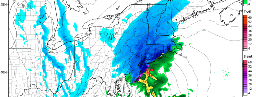
Bands of heavy snow will continue moving into the region late this morning and into this afternoon, as a low pressure system develops and continues to strengthen offshore. This low pressure will shift from a position off the New Jersey coast towards a position south of Southern New England as the day goes on today — strengthening quite significantly as it does so.
In the mid and upper levels of the atmosphere, dynamics will continue to become more impressive this afternoon. This will be most notable in the mid levels, where temperature and wind gradients will enhance a phenomenon known as “Frontogenesis”. This occurs when temperature and wind gradients create enhanced lift — leading to very heavy precipitation.
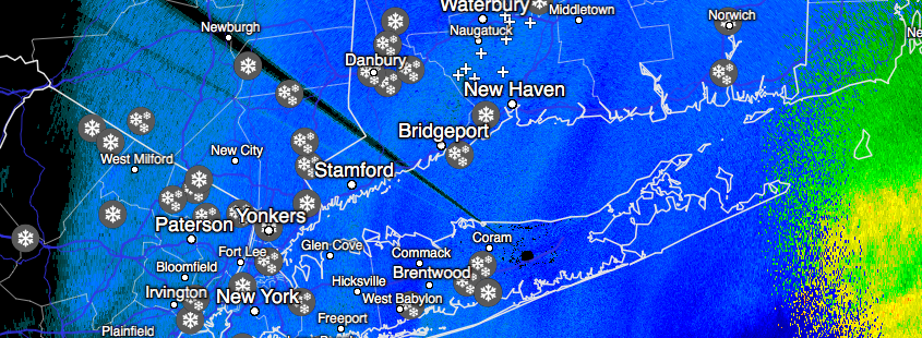
A free mesoscale update this morning for those of you who may possibly be looking for additional information on the evolution of the storm system. The low pressure system continues to develop as expected and only minor tweaks were made to our forecast from yesterday! Snow continues throughout the majority of the area for the next few hours while beginning to gradually taper from west to east around noon.
Heavy snow will develop over Long Island and Connecticut with blizzard conditions and rapid snowfall accumulation expected there from late morning into the early afternoon hours. Our latest video discussion below covers the latest developments and analysis of mesoscale features:
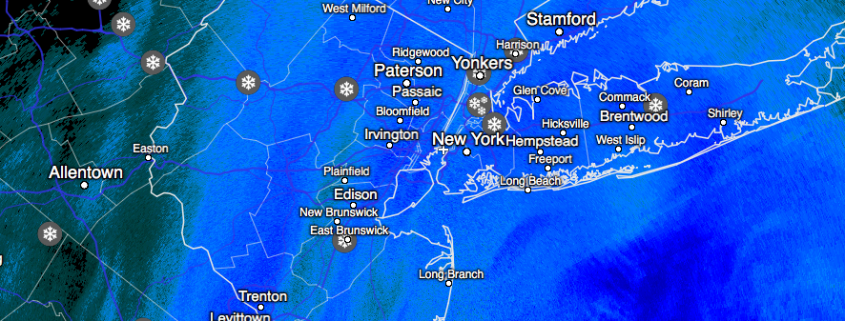
An area of snow, sleet and rain overspread the region overnight. Precipitation started as some sleet and rain in some areas, because temperatures at the surface and aloft were warmer. But as low pressure strengthens near the Delmarva coast, the airmass will be turning colder with increasing northerly winds this morning. This cause precipitation will changeover to snow in all areas by 8am. It has already changed over to all snow from C NJ and north as of 7am.
Then snow will be moderate to heavy at times for rest of this morning through the region. Temperatures will be dropping into the 20s. So this snow will begin accumulate more rapidly on roadways this morning and reducing visibilities.
https://www.nymetroweather.com/wp-content/uploads/2017/02/nam4km_ref_frzn_neus_8.png7721024Miguel Pierrehttps://www.nymetroweather.com/wp-content/uploads/2024/02/Empire-2000-x-300-px-2.pngMiguel Pierre2017-02-09 07:37:532017-02-09 07:37:53AM All Zones Update: Major Snowstorm Underway for Much of the Region
After tracking this potentially significant system over the past couple of days, we have seen some sizeable differences showing up on the computer models regarding potential impacts and accumulations, but this afternoon’s computer model guidance has come into line and it is looking quite likely that the entire New York metro area will be seeing seeing a significant amount of snow during the next 24 hours with a variety of potential impacts.
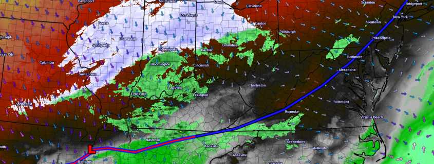
As was talked about on Monday, we have our two key pieces of energy that have to interact and come together this evening in order for our storm to take shape and really begin to intensify. If we look on the 500mb chart below, which is essentially what’s happening up in the atmosphere at roughly 18,000 feet, we can see our two distinct features highlighted in pink. Our first piece can be seen over Kansas City, Missouri this afternoon which has generated the beginnings of our storm over Arkansas and Tennessee with precipitation starting to break out all the way up into Illinois/Indiana/Ohio. As our second feature begins to dive south from its current position to the north of Bismark, North Dakota and interacts with the piece of energy in Missouri, the low pressure currently in the south will begin to speed up and track into northern Tennessee this evening. More precipitation will begin to blossom to the north of the low pressure area as time goes on. This low should steadily deepen as it tracks through Virginia by the early morning hours and bring the onset of the precipitation to the southern New Jersey by 2-3am. This area of snow and rain should gradually move up from southwest to northeast and since we have temperatures in the 50s-60s this afternoon, the initial precipitation may be in the form of a rain/snow mix due to residual warm air. As the precip starts to come down at a heavier rate, a switch to heavier snow/mix is likely for much of the area.
Hi friends! Our website uses cookies to provide an optimal browsing experience for you. New "Cookie Consent" laws mandate us to inform you of this. As long as you're cool with it, just hit OK. You'll only see this message once.
We may request cookies to be set on your device. We use cookies to let us know when you visit our websites, how you interact with us, to enrich your user experience, and to customize your relationship with our website.
Click on the different category headings to find out more. You can also change some of your preferences. Note that blocking some types of cookies may impact your experience on our websites and the services we are able to offer.
Essential Website Cookies
These cookies are strictly necessary to provide you with services available through our website and to use some of its features.
Because these cookies are strictly necessary to deliver the website, refusing them will have impact how our site functions. You always can block or delete cookies by changing your browser settings and force blocking all cookies on this website. But this will always prompt you to accept/refuse cookies when revisiting our site.
We fully respect if you want to refuse cookies but to avoid asking you again and again kindly allow us to store a cookie for that. You are free to opt out any time or opt in for other cookies to get a better experience. If you refuse cookies we will remove all set cookies in our domain.
We provide you with a list of stored cookies on your computer in our domain so you can check what we stored. Due to security reasons we are not able to show or modify cookies from other domains. You can check these in your browser security settings.
Other external services
We also use different external services like Google Webfonts, Google Maps, and external Video providers. Since these providers may collect personal data like your IP address we allow you to block them here. Please be aware that this might heavily reduce the functionality and appearance of our site. Changes will take effect once you reload the page.
-2")