I suppose that sometimes you have to throw your hands up and say “fine”. That’s exactly what we’ll be doing this week as we track another potential winter weather event. But lets get to the weather at hand first – it’s stormy, dreary, windy and mild. Showers this morning will give way to cloudy and drizzly conditions during the late morning and early afternoon as a warm front moves northward. Southerly winds will pick up as the warm front moves towards the NYC Area near noontime.
In 2017, I drove my soft top convertible into Nebraska to storm chase for the first time in my life. I had moved to Minneapolis a few months before, so this was only a natural decision for me to make. Driving a soft top convertible around tornadic supercells isn’t exactly advice i’d be giving anyone else, but it was an amazing experience for me – and it is suffice to say that I have been itching to get back out there.
I don’t claim to be any sort of expert in chasing storms – 2017 was my first crack at this. Since my first chase, I have been lucky enough to meet and interact with many folks who are extremely knowledgeable, and I am working each day to apply my meteorological ability and to learn more about how to chase these storms. This year, I will be storm chasing for over a week. I am lucky enough to be bringing a DSLR camera with me, and recording video in 4k resolution. I’ll have the opportunity to produce video and photos that I hope will be extremely rewarding – and more importantly, I will have the opportunity to chase supercells for several days and document it all; a dream of mine since I was just a kid.
I’ll be chasing from May 25th to June 3rd , and in the next series of blog posts I’ll do my best to outline my research and thought process in determining where to set up “base camp” and how I think the week (and season) will progress.
https://www.nymetroweather.com/wp-content/uploads/2018/03/Screen-Shot-2018-03-30-at-4.30.37-PM.png4031106John Homenukhttps://www.nymetroweather.com/wp-content/uploads/2024/02/Empire-2000-x-300-px-2.pngJohn Homenuk2018-04-02 12:19:502018-05-13 11:06:22Storm Chase 2018: You have to start somewhere
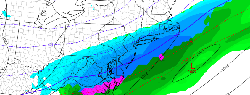
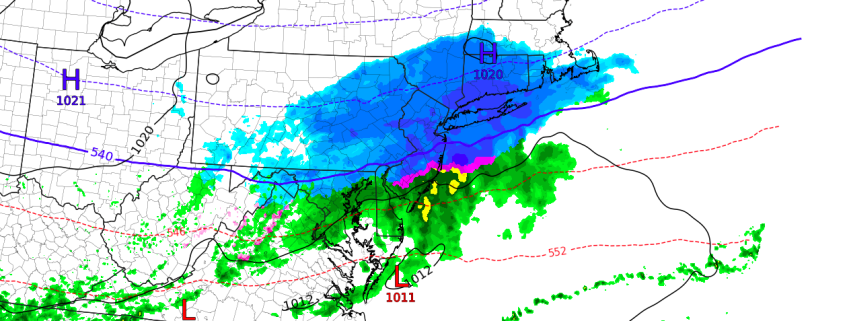
Good afternoon and Happy Easter to those who celebrate! For those of you who enjoyed the beautiful Spring weather this weekend, we have some bad news for you. A weak storm system sliding to the south for the region is expected to strengthen a bit from later Sunday into early Monday morning, with the low pressure center passing off the Mid Atlantic coast during the early morning hours of Monday. Impressive lift along a frontal boundary will allow precipitation to expand and become more steady in nature from late Sunday into Monday.
The system comes right on the edge of an unusually cold airmass that is sliding southward into the Northeast States today. It’s timing is impeccable, really – any faster and the airmass would be too warm for any wintry precipitation, and any slower and the colder air would likely press further south and keep the system more suppressed. Instead, the disturbance comes right along the frontal boundary and will provide wintry precipitation the Northern Mid Atlantic again.
Hi friends! Our website uses cookies to provide an optimal browsing experience for you. New "Cookie Consent" laws mandate us to inform you of this. As long as you're cool with it, just hit OK. You'll only see this message once.
We may request cookies to be set on your device. We use cookies to let us know when you visit our websites, how you interact with us, to enrich your user experience, and to customize your relationship with our website.
Click on the different category headings to find out more. You can also change some of your preferences. Note that blocking some types of cookies may impact your experience on our websites and the services we are able to offer.
Essential Website Cookies
These cookies are strictly necessary to provide you with services available through our website and to use some of its features.
Because these cookies are strictly necessary to deliver the website, refusing them will have impact how our site functions. You always can block or delete cookies by changing your browser settings and force blocking all cookies on this website. But this will always prompt you to accept/refuse cookies when revisiting our site.
We fully respect if you want to refuse cookies but to avoid asking you again and again kindly allow us to store a cookie for that. You are free to opt out any time or opt in for other cookies to get a better experience. If you refuse cookies we will remove all set cookies in our domain.
We provide you with a list of stored cookies on your computer in our domain so you can check what we stored. Due to security reasons we are not able to show or modify cookies from other domains. You can check these in your browser security settings.
Other external services
We also use different external services like Google Webfonts, Google Maps, and external Video providers. Since these providers may collect personal data like your IP address we allow you to block them here. Please be aware that this might heavily reduce the functionality and appearance of our site. Changes will take effect once you reload the page.
-2")