Pattern in transition as December quickly approaches

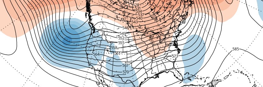
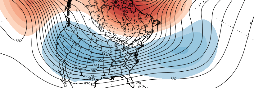
Over the past few weeks, much has been made in regards to a changing hemispheric pattern. Global circulations are in flux, and a much warmer than normal pattern has in fact changed across the Continental United States. However, the changes have been slightly less stout and slightly delayed when compared with initial ideas, and the atmospheric pattern has been left in an overall flux as we head towards December.

The Thanksgiving holiday is often an important time-frame in meteorology as one looks ahead to the upcoming winter. Gone are the days of wild speculation and assumption when it comes to the winter ahead. December is just a week away — and the ideas formulated regarding the pattern as we move into winters first month are beginning to obtain more weight. Some ideas are clearly losing steam, while others garner more attention.

Read more

Premium: Late month pattern change likely to be gradual

As discussed in the winter forecast, the stratospheric polar vortex has been weakened since late October. A wave-breaking event, mainly induced by a large ridge in the Kara Sea, has resulted in 100mb heat fluxes remaining above average. We still believe the polar vortex is likely to be weaker and more disturbed going into this winter, especially compared to the past several years.  However, some resistance from the polar vortex and tropical forcing influences will likely result in more gradual step down into pattern changes over next several weeks.

While westerly zonal winds have decreased to below average levels, a wind reversal or easterly winds aren’t being forecasted, particularly around 10mb and 60N. EPV at 10hpa also appears to shift from being poleward to more equatorward by the third week of November. Despite being severely disrupted; these winds allow for the polar vortex to remain quite large and profound over the high-latitudes. This will likely result in more neutral modality with the AO/NAO over next few weeks.

Read more

Premium: November Outlook and pattern evolution

Changes in the stratosphere have been well documented and explained over the past several days and, despite the fanfare, have not yet had their dramatic impact on the weather pattern across the Continental United States. But in due time, they will, and it will likely begin — ironically — at the very start of the month of November. A much more amplified pattern in the higher latitudes will kick off changes in the Pacific Ocean, starting with a much more amplified Pacific Jet.

This Pacific Jet stream will flood the United States with warm, maritime air as a large vortex forms in the Gulf of Alaska. This is an important development for several reasons moving forward, but in the interest of November alone, its short term significance will be verified by a surge of much above normal temperatures into the Central and eventually Eastern United States.

Read more

How the North Pacific Ocean offers winter clues in November

With Autumn very obviously and officially underway (have you been outside this morning?), questions have begun to surface regarding the upcoming winter — and if the Autumn pattern will foreshadow it. Unfortunately, it isn’t quite as simple as “A cold October means a cold winter” or ” A warm November means a warm winter”. If that were the case, we’d have long range forecasting figured out by now, and there would be much less urgency to winter outlooks. Instead, meteorologists use “drivers”, analogs, teleconnections, and ensemble guidance to help with seasonal forecasts. When used together and properly weighted, these tools provide a higher probability of success in medium to long range forecasting. These methods are far from perfect, but can help offer us clues as to how the coming season will play out.

One major piece of the Winter’s puzzle can be found in the form of “clues” in the North Pacific Ocean. Meteorologists use different oscillations to measure the pattern in the North Pacific over time. The pattern in the Eastern Pacific Ocean is represented by the aptly named “East Pacific Oscillation” (EPO). Like the North Atlantic Oscillation (NAO) the EPO has certain generally predictable outcomes when it oscillates from positive to negative phases.

Read more