Cold flip increasing likely, but longevity in question

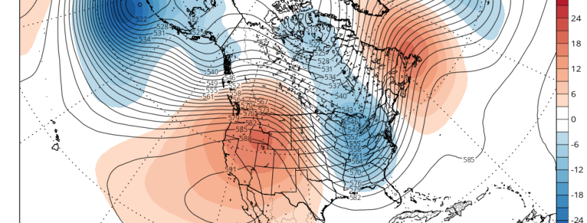
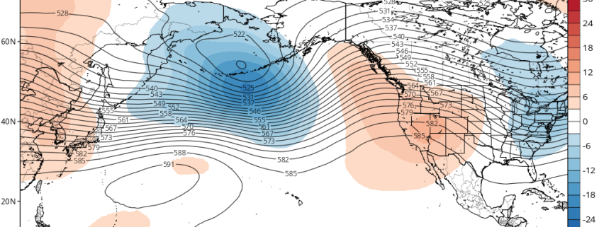
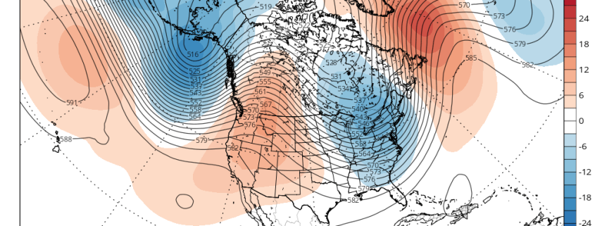
A good Wednesday afternoon to you! While the temperature remains largely above average in the Central and Eastern United States today and over the next few days, we have been discussing for quite some time the idea that a noticeable change is forthcoming. This change is still very much on schedule, and in fact confidence in its occurrence has increased over the past 24 to 48 hours. Forecast model guidance has come into better agreement on the movement of large-scale features throughout the hemisphere.

One thing we continue to discuss internally, however, is the longevity of this flip towards cooler air. Often times, these pattern changes are discussed at length — and with good reason, as they are significant — but there is not enough detail paid to the exact intensity and duration of the change. In this instance, ensemble guidance is already offering some hints as to how the atmosphere will behave after the flip to a cooler pattern in the Central and Eastern USA Week 2.

Read more

Cooler risks increasing, volatile pattern on horizon

Happy Tuesday! For the past several days, discussions have turned from the presence of abnormal and anomalous warmth towards winds of change, which are signaling the return of cooler air and a volatile weather pattern. Overnight forecast models continue to supplement these ideas, with further confirmation that the pattern is set to undergo wholesale changes across the large majority of North America.

As we have discussed, most of these changes are being driven by the Tropical Pacific and the MJO, where global circulations are being affected heavily by its progression over the next few days. While La Niña’s base state has become entrenched in the atmosphere (30-day moving SOI now up to +11.3), the progression of the MJO will allow for a wave-pattern realignments by Days 5-7.

Read more

Winds of change blowing as cooler risks set to return

Happy Monday! Much of the past several weeks have featured a similar synoptic weather headline across North America: Trough west, ridge east. This pattern had led to large scale above-normal temperature anomalies from the Plains eastward to the Mississippi River, exacerbated near the East Coast. But there are growing signs that this pattern will be changing over next few weeks.

Until now, the pattern has been largely driven by the presence of tropical forcing, from the ENSO regions where La Niña conditions have essentially taken over. We can use multiple measures and analytical approaches to understand exactly how the tropical convection is impacting global circulations, one of them being the SOI. This essentially lets us know if the atmosphere is responding in line with an El Niño, La Niña or neither.

Read more

La Nina is in the Atmosphere, but Changes are Possible

After some big warmth, we finally saw some Autumn chill arrive over the past couple of days, which signifies the change of seasons. We are now approaching crunch time when it comes to compiling a winter forecast. In our Winter Forecast Webinar, one of the main topics discussed was the evolution of the La Nina and the effects it is already having on the atmospheric pattern. With La Nina conditions already having been established with regards to feedback in the atmospheric circulation, and the fact that ENSO events tend to peak in November, it would seem to be a given that La Nina would be at least somewhat or even perhaps a major driver this coming winter. And to some extent, we believe that is true. However, there is conflicting evidence regarding the future of the La Nina, and part of this will be evidenced by a pattern change to a +PNA and a trough in the East later this month. These factors will be discussed in detail in this article.

Read more