-2")
The sea breeze and its cooling effect along the coast
Today was another one of those classic days where inland areas soared into the upper 70s, and coastal areas had trouble exceeding 60 degrees, with plenty of wind.
The explanation for this is the sea breeze. Whenever we have a warm, springtime airmass, the temperatures over the land warm up quickly. However, the sea is still relatively cold this time of year, especially considering how cold of a winter we had. The ocean has a high specific heat capacity, which means that it can absorb the same amount of heat as the land does, but will not warm up nearly as much as the land. Thus, during the day, the land will often be much warmer than the ocean.
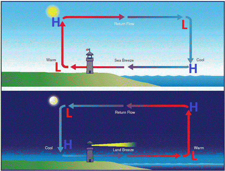
The sea breeze circulation (top) and land breeze circulation (bottom). (Free Online Pilot Ground School).
Once the land heats up, thermodynamics dictate that the warm air must rise, since it is less dense. However, the relatively cold ocean does not have this same heat, as it is more dense, so the air does not rise. The rising air over the land creates a slightly lower surface pressure, since the air is escaping the surface, rather than exerting a force on it. The lack of rising air over the sea thus creates a slightly higher surface pressure, relative to the land. The atmosphere always wants to balance itself out, so to compensate for the air over the land escaping the surface, air from higher pressure has to flow towards it. This air happens to be coming from the colder ocean, which helps to create colder temperatures and windier conditions along the coast.
The circulation gets reinforced because when the air over the land rises, it creates an area of higher pressure at the upper levels of the atmosphere, since lots of air is rushing towards the upper levels. However, over the sea, there is no air rising into the upper levels, so the pressure is relatively lower there. The air with higher pressure aloft on the land thus flows towards the area with lower pressure above the sea. Now that this air is above the sea — where air at the surface is already heading towards the land — the air has to sink to replace the air that is leaving the sea. This sinking air towards the sea surface reinforces the high pressure, which reinforces the source of air that is blowing towards the land, which reinforces the sea breeze.
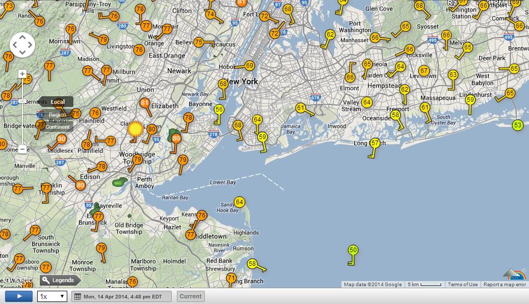
Temperature and wind observations taken from Monday (4/14/14) afternoon at 4:48pm. Notice temperatures approaching 80 in New Jersey with relatively light winds, yet much cooler and windier conditions on Long Island. Also notice how in some areas, the southerly winds are stronger on Long Island compared to areas further west (Weather Underground).