Unsettled Thursday, eyes on weekend coastal storm

Good morning! A beautifully pleasant and calm weather day on Wednesday is behind us, and the weather will take a more transitional and unsettled turn in the Northeast states today. You can thank the weakening grip of a large mid level ridge for that, as its departure will open the door for multiple disturbances to move into the region. High pressure has already begun its shift off the Eastern US coast this morning.

A disturbance in the atmosphere’s mid and upper levels will begin to approach the area this afternoon and evening. The first thought going through many peoples minds will be the potential for strong and severe thunderstorms – but there are several mitigating factors that will be acting against those chances today. Instead, the potential for showers and a few isolated thunderstorms is expected to evolve.

Read more

Video Analysis: Potential Nor’Easter on Friday into Saturday

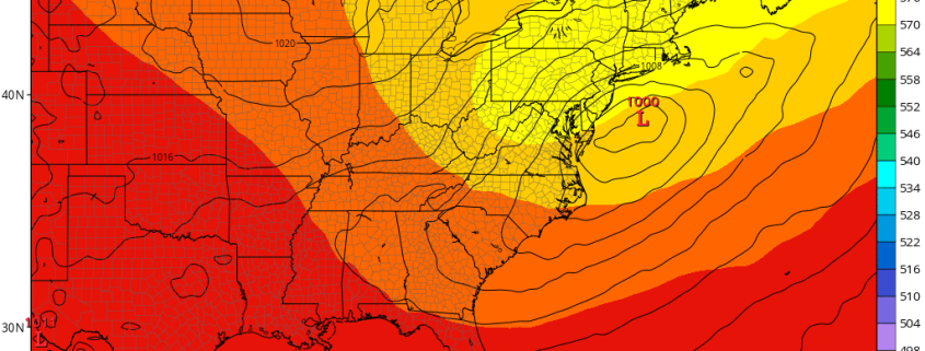
Good evening, everyone! We hope you all enjoyed this lovely Wednesday. We have a lot to talk about with this potential upcoming Nor’Easter on Friday into Saturday. Late July may be the hardest time of year to get a Nor’Easter, with the main jet stream generally being protracted towards the Arctic rather than diving down towards the mid-latitudes. But with a strong blocking pattern with a -NAO blocking ridge in Greenland as well as a ridge forming out west, we are able to get some of the necessary ingredients we normally see in the Fall and Winter months for a potential Nor’Easter.

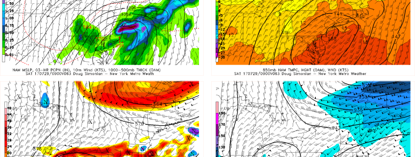
A strong shortwave will be diving on the downstream side of this ridge and into the Great Lakes on Thursday into Friday. Thanks to this blocking pattern, it will be able to slow down and amplify as it does so, turning into a very strong shortwave that closes off at 500mb and even at 300mb. The blocking pattern and subsequent vortex in Southeast Canada will also allow for a strong jet streak to form in New England, placing us in the right-entrance region of this jet streak, which is great for lift and precipitation. But what makes this forecast tricky is that the interplay between the main shortwave and the Canadian vortex is very tricky and has a lot of nuances, and the fact that some energy crashing into the West Coast will be flattening the PNA ridge and make our shortwave take on a positive tilt. This may make it hard for the low pressure to truly climb the coast, and instead it may slide ENE when it reaches our latitude.

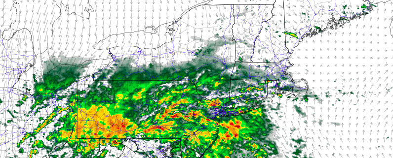
The above video explains all of the details and potential complications to the forecast, as well as the very unique set of ingredients that could come together to make this a powerful storm with high impacts for our area. As of now, we think the heaviest rain may be to our south, but the jet streak aloft and deepening storm may allow enough precipitation to spread out well ahead of the low to still give our area over 1″ of rain. But if all of the ingredients come together and consolidate, a large portion of our area could easily get 2″ or more — even locally much more — of rain.

Premium: Coastal Storm with Heavy Rainfall Possible Late Week

After the heat wave last week, more cooler, unsettled weather has returned to the region, as a trough moves through the Northeast.  More clouds and onshore flow this week have kept high temperatures well below average over the region — it certainly doesn’t feel like the middle of summer. High pressure will support more pleasant, warmer weather on Wednesday. Then it looks like something we often see during the fall and winter months: a coastal storm with the potential for heavy rainfall by Thursday night and Friday and perhaps into this weekend as well. But uncertainty is still quite high with exactly how this storm evolve, its timing, and how much impact it will have on the region.

Read more

PM Update: Torrential rain tonight and Monday throughout New England

Happy Sunday! We hope you have all been able to enjoy a lovely weekend — which, weather wise, turned out to be reasonably pleasant. This will change later this evening, and is already in the process of doing so throughout much of the Mid Atlantic. A warm front currently situated over the Northern Mid Atlantic states has served as the focal point for the development of thunderstorms this afternoon, but these are quickly merging into a larger-scale threat of heavy rain.

Heavy rain will continue to shift northward this evening as the warm front begins to respond to a developing impressive synoptic-scale storm evolution. A large and impressive shortwave disturbance is forecast to move northward from the Mid Atlantic into the Northeast, aiding in the development of widespread lift for heavy precipitation. This will allow a threat of heavy rain to spread northward from the Mid Atlantic into PA, NJ, and NY later tonight.

Read more