Here’s Why the Warmth This December Has Been Historic

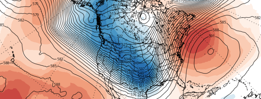
With the release of our Winter Forecast came the news that December was likely to average above normal in terms of temperature. Historically, almost all Strong El Nino events featured warmer than normal December’s in the Eastern US. The warmth this December, however, has been far more exceptional than anticipated. Temperatures have been well above average for almost all of the month. Multiple record highs have been broken in New Jersey and New York’s climate reporting stations. And, even still, a more anomalous warm surge is expected during the period of time near Christmas through New Years.

Currently, temperatures are running around 10 degrees above average. At this rate, extrapolating forward, December could average more than 5 degrees above normal. The meteorological reasoning behind this exceptional event features a juxtaposition of some very anomalous features:

Read more

The meteorology, and stats, behind the 2015 Hurricane Season

Meteorological Winter began today, and the 2015 Hurricane Season officially ended yesterday, marking a transition in seasons — and the attention of meteorologists worldwide. While the season will be remembered for a few more significant storms, the overall season in the Atlantic was quiet. There were 11 named storms and one more tropical depression. Four of those named storms became hurricanes and two of those became major hurricanes (Category 3 or higher). The number of named  storms is actually about average for Atlantic hurricane seasons between 1966-2009. But the number of hurricanes is below the average of 6 for the season. Only two storms made landfall in the in the United States: An early season tropical storm named Ana over North Carolina in May, and then Tropical Storm Bill over Texas in June. There hasn’t been a major hurricane landfall in the United States since Hurricane Wilma in 2005 — which is now 10 years ago.

Read more

The meteorology behind Hurricane Sandy’s very low pressure

Nearly three years since Hurricane Sandy, many of her visual scars have faded. The memories of the storm, for many, have not. Meteorologically, Sandy remains just as incredible now as she was then — an unbelievable display of atmospheric power. One of the most fascinating aspects of Sandy was how strong she was, despite entering cooler waters. The meteorology behind her pressure is powerful and intricate, still, three years later.

Hurricanes have a strong warm core at the surface, weaken with height, and are barotropic — meaning there are no temperature or density gradients in their environment. This means that they are symmetric — their warm core is entirely surrounded by slightly cooler, but still abundantly warm air. The combination leads to hurricanes being vertically stacked (not tilted with height). Thus, hurricanes need warm water and weak upper-level winds in order to strengthen. Strong upper-level winds can choke a hurricane’s outflow channel, and advect in new airmasses of different temperatures — providing temperature gradients that hinder their development.

In further south latitudes, waters tend to be warmer, and the jet stream tends to be weak. As you head further north, however, the water becomes colder and the jet stream strengthens, leading to stronger upper-level winds. This helps to weaken a hurricane’s warm core at the surface, and tilt its vertically stacked structure, weakening the storm. However, as Sandy headed north, she was able to maintain category one hurricane strength with abnormally low pressures and eventually went on to cause widespread devastation. Why?

Read more

NWS adjusts curiously low snowfall totals at Central Park

For years now, the meteorological community has been aware that Central Park usually reports snowfall totals lower than its surroundings. For reasons not completely known, surrounding stations at Newark, LaGuardia, and Teterboro Airports almost always seem to report higher snowfall totals. Even local, public reports in Midtown and Lower Manhattan seem to consistently come in higher than the Central Park Zoo. This year, the National Weather Service took to the task and edited the official Central Park reports to better match surrounding data.

Snowfall amounts from three separate storms this winter:

January 6th, 2015: Snowfall total adjusted from 0.5″ to 1.0″ (+0.5″)

January 24th, 2015: Snowfall total adjusted from 2.5″ to 3.6″ (+1.1″)

February 2nd, 2015: Snowfall total adjusted from 3.3″ to 5.0″ (+1.7″)

Read more