Winter Outlook 2013-14

Disclaimer: Long range outlooks continue to be a work in progress, and although our understanding of meteorological processes has grown, the nonlinear, chaotic nature of weather makes this task a very difficult one. With that being said, We will provide meteorological reasoning for what we believe the upcoming winter’s patterns will be!

Primary variables of examination:

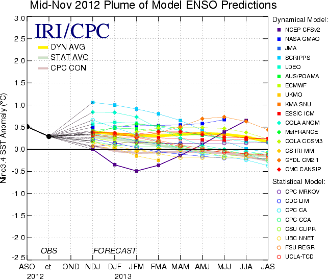
  1. El Nino Southern Oscillation (ENSO),
  2. North Atlantic Oscillation (NAO),
  3. Arctic Oscillation (AO),
  4. East Pacific Oscillation (EPO),
  5. Pacific North American index (PNA),
  6.  Sea surface temperature anomalies (SSTA) in the Pacific and Atlantic

Other factors examined but may or may not be mentioned: Pacific Decadal Oscillation (PDO), Atlantic Multi-decadal Oscillation (AMO), Quasi-Biennial Oscillation (QBO), Stratospheric trends and temperature anomalies, Solar trends, specifically geomagnetic activity, solar flux, and sunspots, Pattern persistence, Analog years (years with similar patterns to the current year)

Short Description of Variables:

We will be utilizing the above abbreviations of teleconnection indices throughout the outlook. These variables reflect the atmospheric circulation patterns for certain geographical areas. The AO refers to patterns within the Arctic circle, the NAO in the north Atlantic, the PNA in the western part of North America, and the EPO in the northern/eastern Pacific, Alaska and western Canada. If you are a cold / snow lover in the Eastern US, you generally want to see the above indices in their negative phase, except for the PNA, which is more favorable in its positive phase for Eastern cold. Negative AO, NAO, and EPO generally correlate to enhanced blocking and high pressure to our north, and to balance it out, low pressure and troughs usually form underneath in the middle latitudes (our area). In contrast, positive AO, NAO, and EPO generally yield low pressure and less blocking to our north, and as a balance, we experience high pressure and more ridging. There are exceptions to the rules, but most of the time, if you like cold / snow, the preferred index phases are negative AO, NAO, EPO, and positive PNA.

Read more

October blocking could hint at winter pattern

Autumn began just a few days ago, but the weather pattern has already adjusted to the fall-like pattern with temperatures falling into the 30’s and 40’s at night. The first cold nights of the year typically come in mid to late September, as the warm and humid days of summer fade. The cooler, more crisp air gives us the first small taste of the cold winter which is only a handful of weeks away. The pattern has begun its seasonal change, and we are beginning to feel the effects of it. Yet, the best hints of what the winter pattern may have in store for us may be hundreds and thousands of miles to our north — over the high latitude/arctic region.

Seasonal forecasting can be a tedious and intricate task for meteorologists. Many times, meteorologists and forecasters alike find themselves drawing upon past events, analogs, and other research for help with predicting the months ahead. This is especially true in the Autumn season, as winter forecasting begins. Meteorologists are about to enter a flurry of forecasting over the next few months (yes, we are somehow enjoying this benign and calm weather right now). So as we look forward to the winter, we can often use the preceding months as indicators of the pattern to come. The pattern itself can often tip its hand, giving us a clue as to what we may be dealing with a few months down the road.

The words “high latitude blocking” likely will instantly bring back memories of some of our stronger storms and more volatile weather patterns in recent memory. The Blizzard of 2010, Hurricane Sandy, the Nor’Easter just a few weeks afterward. They all occurred during episodes of high latitude blocking, with a negative NAO cor North Atlantic Oscillation (for a background and more information on the NAO, click here). Still, high latitude blocking episodes which occur months before these events can often serve as accurate predictors, foreshadowing in a sense, of the upcoming pattern a few months after. A few months ago, we published some research on the blocking pattern during the month of May helping to predict the pattern during the summer months.

For a bit of reference, high latitude blocking refers to blocking ridges which occur in the higher latitudes over Canada and the North Atlantic (background on atmospheric blocking can be found here). These ridges slow down the jet stream/weather pattern. The high latitude blocking over Greenland, the North Atlantic, or Canada during the winter months often leads to the displacement of very cold arctic air over the United States, very often the Northeast US. The more amplified/slower pattern also leads to the potential for large coastal storm systems and has historically featured snowier and colder periods in the Northeast US.

Read more

Summer Outlook 2013

Below, you will find our 2013 Summer Outlook. We’ve laid out the details and broken down the expected temperatures and precipitation, as well as factors and reasoning involved in the outlook. We encourage your comments, thoughts and feedback!

Factors/Expectations:

1) Neutral ENSO conditions should persist through the upcoming summer with sea surface temperature anomalies (SSTA) not far from normal in the tropical Pacific.

2) The negative Pacific Decadal Oscillation (PDO), or cold eastern Pacific, that we saw through winter has weakened somewhat, but will continue to be slightly negative/cold this summer season.

3) The Atlantic Multidecadal Oscillation (AMO) continues to run slightly positive/warm, with a SSTA profile of warmth near the East Coast, cold in the central Atlantic, and warm in the deep tropics.

4) The strong blocking pattern of negative North Atlantic Oscillation (NAO) and negative Arctic Oscillation (AO) that yielded a very cold late winter/early winter has since dissipated. Both indices have been predominately neutral to slightly positive over the past several weeks, and the historical tendency is for this to continue into the ensuing summer. There may be a one month period of –NAO/AO, but the overall signaling should be near neutral or slightly positive in terms of the NAO/AO blocking indicators.

5) The closest, most similar analog to the present conditions in terms of PDO, NAO, AO, PNA, ENSO, and other factors appears to be 2001. Note that analogs are utilized as tools to identify patterns and obtain clues from the past that may enable us to more accurately forecast the future. No one year is identical in pattern to another year.

6) Palmer Drought Index and Standardized Precipitation Index for the month of May have shown to be excellent foretellers of the June-July-August (JJA) temperature anomalies across the Continental United States (CONUS). The correlation is a strong one, when examining the past 20 years. Areas of drought/dry persistence in May tend to be the breeding grounds for heat in the summer and strong ridging. Likewise, areas of wetness / high soil moisture in the late meteorological spring tend to indicate an ensuing summer of coolness or at least less frequent heat spells.

7) Patterns of strong blocking in the late spring often foretell summers of strong USA heat while patterns devoid of blocking in late spring tend to yield summers of weaker USA heat.

Read more

Winter Outlook 2012-13

Introduction/Methodology:

Last winter featured a highly dominant pattern of lower pressures in the Arctic and higher pressures in the mid-latitudes, especially the United States. This was a classic +AO/NAO regime in which the strong jet stream precluded the amplification of cold troughs into any part of the US. As a result, the November-April period of 2011-12 was one of the warmest and least snowy on record for the lower 48 States. This winter, since the outlook is being issued a month later than last year, I hope to avoid unforeseen patterns with November’s data helping to strengthen statistical and physical correlation for the December-January-February (DJF) meteorological winter season. Factors that will be considered, but not limited to: ENSO, PDO, PNA, NAO, AO, EPO, Solar activity / trends, Stratospheric activity / trends, QBO, forecast modeling, pattern persistence and analogs (years with patterns similar to the present, rolled forward into the future to aid in long term projections). Keep in mind that we are still in the “pioneering” phase with some aspects of long range forecasting, and thus, one cannot attribute the same expectations as one would for a short or medium range forecast (1 month or less). Furthermore, do not expect the level of detail that is provided in short or medium forecasts to appear in long range outlooks. The hope is that the data we collect from the autumn season will aid in forming a general picture of the temperature and precipitation patterns of the future. These data take the form of numerous statistical correlations concerning teleconnection indices, as well as perceived physical forcing mechanisms in both the atmosphere and stratosphere.

Pacific Signaling

The El Nino Southern Oscillation (ENSO) index should be in a predominately warm-neutral phase for this winter season, meaning, region 3.4 sea surface temperature anomalies (SSTA) in the central tropical pacific will be in the 0.0c to +0.5c range.

Read more