2016 Summer Forecast

Over the past several months, our forecasters have monitored several extremely important variables, indices, and the trends in their behavior. We will be utilizing those variables and indices throughout our summer forecast. These variables reflect the atmospheric circulation patterns for certain geographical areas. For example, the AO refers to patterns within the Arctic Circle. The NAO refers to pattern characteristics in the North Atlantic, the PNA in the western part of North America, the PDO in the Pacific Ocean, and the EPO in the Northern and Eastern Pacific Ocean.

Typically, negative AO, NAO and EPO values correlate to enhanced high latitude blocking and high pressure to our north while lower pressure areas and troughs usually form underneath that high latitude ridging in the middle latitudes. In contrast, positive AO, NAO and EPO values generally yield lower pressure and less blocking to our north, while higher pressure and more ridging tends to build into the middle latitudes.

Read more

From Strong El Nino to Strong La Nina?

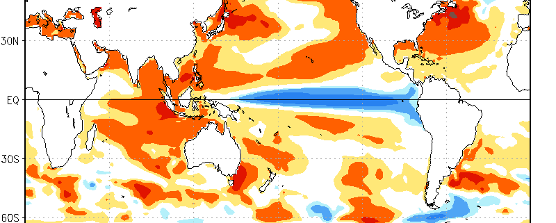
Over the past few months, we have had an El Nino. In fact, it has been one of the strongest El Ninos on record, and is one of the reasons why this past winter was generally quite warm, and why the Pacific Jet stream was so fast and active. It also helped to trigger the historic blizzard we had on January 22nd-23rd. Currently, while we still have an El Nino at the surface, conditions are rapidly flipping towards La Nina when one takes a deeper look at the oceans, as well as the trends in the climate models.

Under “normal” conditions, where there is no El Nino nor a La Nina, the trade winds are persistent in the Equatorial Pacific, which generally blow from east to west. This “pushes” the warmest Equatorial waters further west towards Australia and Indonesia, leaving cooler waters in their wake with more upwelling of subsurface cool water as well. Over the past year or so, these trade winds rapidly weakened and even reversed in some areas, allowing warm water to flow back eastward (instead of getting forced westward) towards the entire Equatorial Pacific, spreading eastward towards Peru. As warmer water builds, Oceanic Kelvin waves, which move from west to east — but also move up (upwelling) and down (downwelling) to transport warm or cool water vertically — are able to push warm water to strong depths and generate “pools” of warm water. This allows an El Nino to sustain itself, as even when a brief period of trade wind acceleration takes place and more upwelling happens, the water upwelled is still warm. It can take months to fully reserve a new El Nino equilibrium.

But finally, the proverbial rubber band is snapping.

Read more

Five things to expect during the upcoming winter

Just about a month ago, we released our 2015-2016 Winter Forecast to the public. The forecast featured a tremendous amount of information, research, and data, most of it very technical in nature. With winter only a few weeks away, there is no better time than now for us to lay out the ideas we gathered in a more simplistic form. After all of our work to compile the forecast, there are five general things you should expect during this upcoming winter season.

1) The Winter of 2015-2016 will start off warm

Over the past few weeks, much has been made in regards to the warm pattern setting up for the month of December. Truth be told, confidence has never been higher that December will be a warmer than normal month with less snow than normal as well. Much of this can be attributed to the development and effects of a strong El Nino in the Equatorial Pacific. But some, also, has to do with the surrounding global circulations.

This month, the stratospheric polar vortex (way up there) tightened and strengthened over the North Pole. While this doesn’t totally eliminate any chance for our area to experience cold air, it does make it more difficult. A tighter and more consolidated stratospheric polar vortex means less atmospheric disruption in that region; i.e: Less high latitude blocking, or ridges, to displace the cold air farther south. This vortex is expected to weaken over the next 30 to 50 days, eventually moving and/or splitting and promoting high latitude blocking during the second half of the winter.

Read more

Winter Forecast 2015-2016

You can view the entire 2015-2016 Winter Forecast in a PDF file by clicking here.

Primary Methodologies and Variables of Examination

  • El Nino Southern Oscillation (ENSO)
  • Arctic Oscillation (AO)
  • East Pacific Oscillation (EPO)
  • Pacific Decadal Oscillation (PDO)
  • North Atlantic Oscillation (NAO)
  • Siberian/Eurasian Snow cover and Stratospheric Warming
  • Solar Activity
  • Sea Surface Temperature Anomalies (SSTA)

Explanation of Variables

Over the past several months, our forecasters have monitored the above variables (plus others) and the trends in their behavior. We will be utilizing the above variables and indices, as well as their abbreviations, throughout the winter forecast. These variables reflect the atmospheric circulation patterns for certain geographical areas. For example, the AO refers to patterns within the Arctic Circle. The NAO refers to pattern characteristics in the North Atlantic, the PNA in the western part of North America, the PDO in the Pacific Ocean, and the EPO in the Northern and Eastern Pacific Ocean.

Typically, negative AO, NAO and EPO values correlate to enhanced high latitude blocking and high pressure to our north while lower pressure areas and troughs usually form underneath that high latitude ridging in the middle latitudes. In contrast, positive AO, NAO and EPO values generally yield lower pressure and less blocking to our north, while higher pressure and more ridging tends to build into the middle latitudes. There are exceptions to the rule, but generally the negative state of the above listed indices yields colder, more snowy weather in our area during the winter months.
Read more