Strong cold front to bring rain, thunderstorms, late tonight and Saturday

The persistent cloud-cover over much of the region during the past several days finally broke today, leading to a beautiful fall day. However, as the evening progresses, clouds will be on the increase due to a strong low pressure system in Ontario, Canada, and its associated strong cold frontal boundary dragging to its south. These features will be moving eastward throughout the night and approach our area during the day tomorrow.

Today's NAM Model valid for 2:00pm tomorrow afternoon shows the strong cold front crossing our area, with much colder 850mb temperatures about to move in.

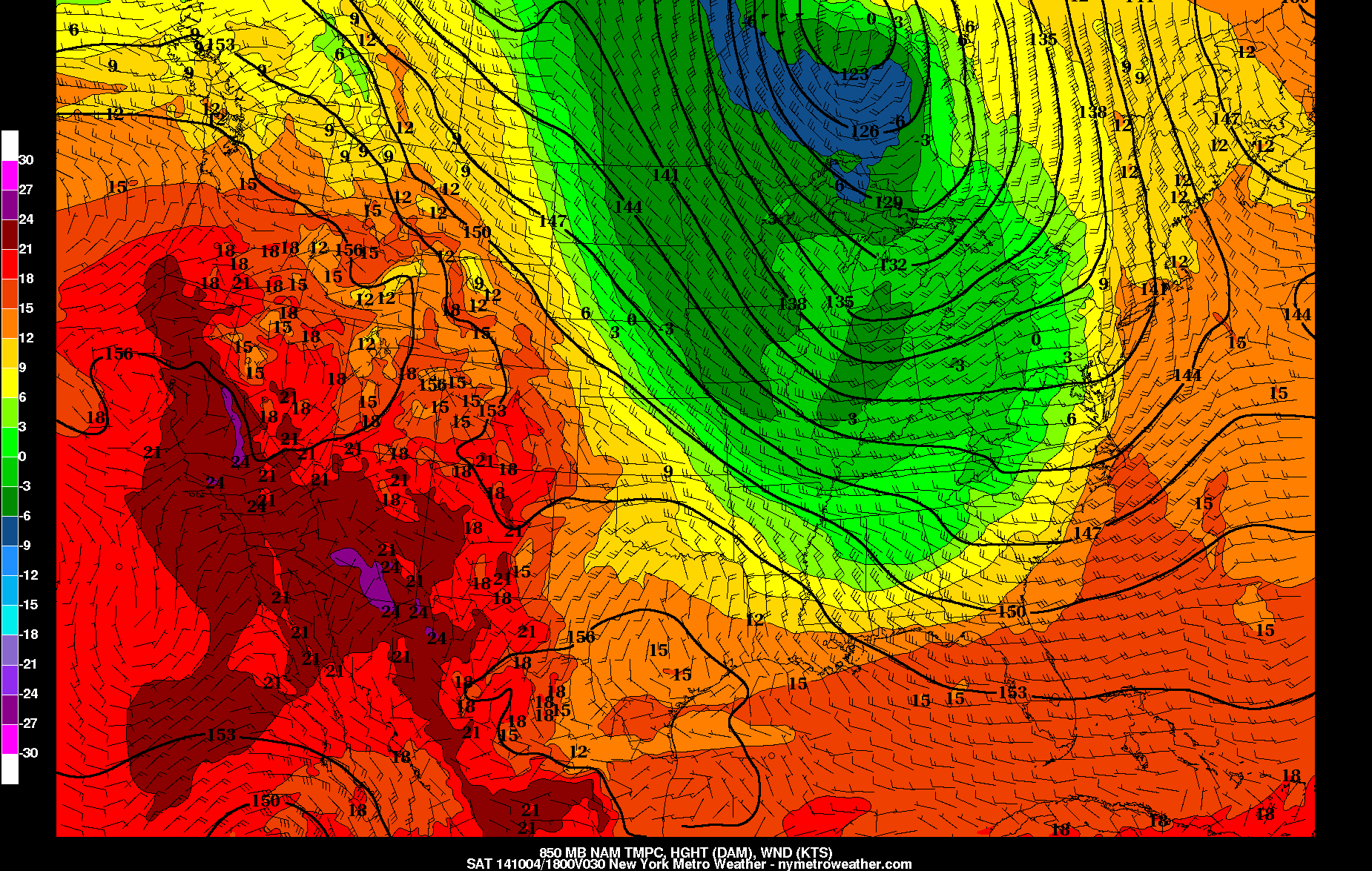
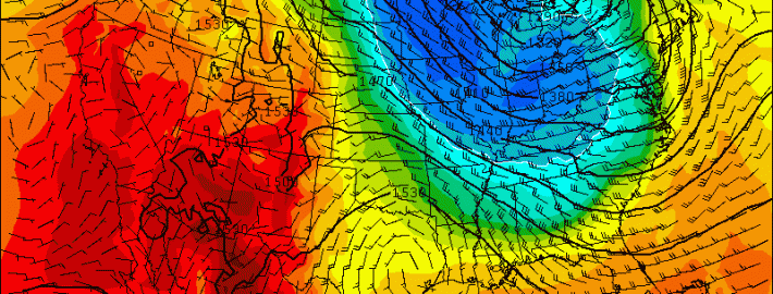
Today’s NAM Model valid for 2:00pm tomorrow afternoon shows the strong cold front crossing our area, with much colder 850mb temperatures about to move in.

Fortunately, for people going out tonight, any rain should hold off until midnight or slightly later for western sections, and after 2:00am for NYC and east. Plus, given that we are still on the warm side of the cold front, temperatures will not be all that chilly tonight, with lows around 60.

7:00pm: Mostly cloudy skies, temperatures in the low to mid 60s.

10:00pm: Cloudy skies, temperatures in the low 60s.

Midnight: Cloudy skies, temperatures in the low 60s. A 30% chance of showers for western zones, with only about a 10% chance of showers for NYC and east.

2:00am: A 60% chance of rain for western zones, with a 30% chance of rain for NYC and east, and temperatures around 60.

4:00am: An 80% chance of rain for western zones with a rumble of thunder possible, and a 60% chance of rain for NYC and east, with temperatures around 60.

Read more

Here comes the Autumns first big cold front

Right on cue. We spoke about this potential a few days ago when we noted the medium range forecast models suggesting the presence of high latitude ridging and blocking. These some models now agree that a significant cold front will shift from the Great Lakes and Central United States through the Northeastern United States this weekend; plowing through our area from Saturday Night into Sunday. Showers and some thunderstorms are possible with its passage, right on the periphery of a major mid and upper level trough.

The temperature different won’t really be felt on Saturday despite the fronts passage. Initially warmer air, streaming in with a southerly flow ahead of the front, will keep temperatures in the 60’s and 70’s on Saturday. After some showers and maybe an isolated storm with gusty winds, the difference will become noticeable as winds shift to west-northwesterly and much, much cooler air begins moving in aloft.

Read more

PM Update: Cloudy, damp behind backdoor front

Ah, that phrase again. Backdoor cold fronts often manifest themselves in New England and the Mid Atlantic during the transition seasons of Autumn and Spring. This year, of course, is no exception. We had plenty of them in the Spring, and this is our first of Autumn. We even wrote a detailed breakdown of how they work, and why they affect our area. Regardless, a backdoor front associated with a mid level disturbance overhead slipped past the region yesterday, and we’re feeling the full effects of it today with cloudy and damp weather.

A weak low pressure system off the coast is bringing enhanced rainfall to parts of Southern New England, Eastern Long Island and Connecticut tonight. The best forcing and lift for rain will remain to the east of the areas, but periods of more steady rain and showers are possible through tonight and into Thursday. Tonight, as a result, will remain quite cool and damp. We suggest bringing a jacket if you’re headed out. You may want to carry an umbrella along, too, just to be safe.

Read more

In Autumn, all eyes are on the North Pacific

With Autumn officially underway and the leaves starting to turn, many are beginning to wonder about the upcoming winter, and if the Autumn pattern will foreshadow it. Unfortunately, it is not as easy as “cold October yields cold winter” or “warm October yields warm Winter”. If that were the case, we’d have long range forecasting figured out by now, and there would be no need for winter outlooks. The best we have for now are correlations, analogs, physical pattern drivers, and pattern persistence. When added together, the summation of these various factors provide a higher probability of success in medium to long range forecasting, but these methods are far from perfect. The evolution of different atmospheric oscillations during the autumn season can give us a substantial clue as to the ensuing winter’s dominant index modalities.

In this particular case, let’s examine the autumn north pacific pattern of years since 1990, giving us a sample size of 22+ years. The North Pacific pattern is often represented as the East Pacific Oscillation (EPO). Like the North Atlantic Oscillation the EPO has certain, generally predictable outcomes when it oscillates from positive to negative phases. The positive phase of the EPO is usually associated with lower than normal heights across the northeastern Pacific, much of Alaska, and northwestern Canada. Conversely, the negative phase of the EPO generally produces higher than normal heights over the region just described. The positive (+EPO) tends to flood the United States with maritime pacific air due to the low pressure around Alaska, while the negative (-EPO) acts as a block to maritime pacific air due to high pressure over the NE Pacific/Alaska. The -EPO often sets up a cross polar flow with high pressure centered over Alaska and the flow oriented across the north pole from Siberia into Canada. The -EPO pattern has yielded some of most impressive, severe arctic outbreaks on record.

Read more