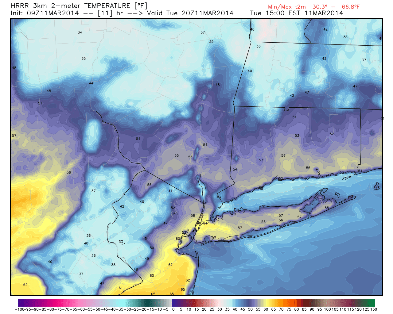
Fair weather and warming temperatures will be the story on Tuesday, as westerly winds continue and temperatures warm up aloft. Highs on Monday, which reached into the 50’s, will be bested by the early afternoon hours through much of the area. The warmest temperature readings are likely to come from Southern and Central NJ, where short term forecast models show some potential for temperatures to reach into the upper 60’s by afternoon with abundant sunshine. Despite being a few degrees cooler, areas farther north will also be feeling the warmth especially compared to what the past several weeks have had to offer.
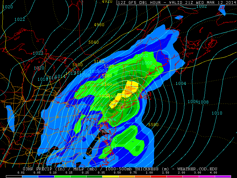
The warmth will feel a bit more muggy by Wednesday, as a storm system approaches the area from the Tennessee Valley and eventually tracks fairly close to the area by later Wednesday. Drizzle and increasing clouds will put a damper on what otherwise will be another warmer than normal day, especially south of a warm front which is forecast to position itself from west to east in Central New Jersey. Rain will become more steady later in the day on Wednesday and may actually become heavy for a period of time late Wednesday night.
HRRR model forecasting high temperatures in the mid 60’s in parts of the area Tuesday afternoon.
It has been a while since we have been able to confidently back off on winter weather potential; in a season which has featured an absolutely tremendous amount of snowfall events and a staggering amount of over-performers. With the upcoming midweek storm, the winter weather potential was fairly clear from the get go. A southern stream disturbance meandering near the Mississippi River, some cold air in place to start, and an energetic northern stream disturbance racing southeastward from Canada to the Great Lakes. The summation of all of these parts usually results in a winter weather event somewhere in the Northeast US, and this situation likely will end no differently. But a delicate evolution of events is likely to produce a warmer situation in our local area.
The evolution of the system begins well to our west, over the Rockies and International Border in the Northern US. As mentioned earlier, a southern stream disturbance will eject from Mexico into the Southern United States (likely providing a fairly significant amount of moisture) while a disturbance from the northern stream slides southeastward to phase with it. At the time of the interaction, a lack of high latitude blocking (over the Northwest Atlantic and Greenland) will allow for height rises over the East Coast, and warmer air intrusion ahead of the developing system. This will be less of a concern over New England, but all models agree that the warm air will likely warm both the mid levels and the surface and help to keep the thermal gradient to our north — meaning more rain than snow in much of the area.
GFS model showing a low pressure system tracking very close to the area on Wednesday afternoon.
https://www.nymetroweather.com/wp-content/uploads/2024/02/Empire-2000-x-300-px-2.png00John Homenukhttps://www.nymetroweather.com/wp-content/uploads/2024/02/Empire-2000-x-300-px-2.pngJohn Homenuk2014-03-09 17:46:462014-03-09 17:46:46Midweek storm trending more wet than white
Plenty of clouds have been the rule for today, which have helped to keep temperatures in the 30s. A storm system to our south is slowly moving northward, but will not interact with the jet stream to the north. This will keep the storm system out to sea. The lower pressures from the jet stream to the north, as well as the lower pressures out to sea, will help to create a relative wedge of higher pressures between them, which is another reason why the storm will ultimately miss us, as higher pressures create sinking air, thus a lack of lift. There is the outside chance of a few very light sleet pellets or drizzle in coastal sections, but we’re definitely leaning against that, and even if that were to occur, it would not disrupt any travel.
As the storm pulls away throughout the night, clouds will gradually diminish, as winds turn to the north. The initial cloud cover will prevent temperatures from dropping much below freezing, however.
Moving to tomorrow, a cold front will be developing in the Great Lakes via the northern jet stream, and moving eastward throughout tomorrow. This will help to the winds to turn more westerly as opposed to due northerly. This, combined with the previous subsidence left from the departing storm system will lead to sunny skies for tomorrow and a potentially warm day.
Today’s high-resolution NAM run shows 850mb temperatures around +3C at 1:00pm tomorrow afternoon, which support high temperatures in the 50s, given enough sunshine and mixing. (PSU E-Wall)
Temperatures aloft have slowly warmed due to more ridging building in between the low pressure offshore, and the low pressure in the northern stream. As sunshine comes out in full-force tomorrow, the relatively strong sun angle, combined with the fact that winds will be turning more to the west should lead to temperatures warmer than forecast by most other outlets. 850mb temperatures will be around +3C at 1:00pm and the flow will be pretty strong out of the west, as shown in the map above. This leads to downsloping off the Appalachian Mountains, which warms and compresses the air. The only thing that would prevent temperatures from exceeding 50 degrees is if the atmosphere takes a bit too long to become truly mixed, because of the previous higher pressures preventing much atmospheric turbulence. However, due to the winds and strong sun angles, we believe the atmosphere will become mixed by around noon or 1:00pm. This would help to translate the warm temperatures aloft to the surface. With a strong sun angle, you can often add 10 to 12C to the 850mb temperatures to the surface.
Interestingly enough, BUFKIT soundings show the atmosphere becoming fully mixed at 3:00pm, but temperatures aloft have cooled a bit by then, due to the approaching cold front — when a cold front approaches, the temperatures aloft fall faster than they do at the surface, due to stronger winds aloft. This is why most high temperature forecasts are only in the 40s for tomorrow. But just move the mixing up a couple of hours, and we are easily in the 50s for tomorrow, which seems to make sense given the strong sunshine. Thus, we feel that temperatures should reach the low 50s tomorrow, which will feel quite pleasant due to how cold it had been previously. Average temperatures this time of year are actually in the mid to upper 40s, so tomorrow’s warmth will not be unseasonable.
The cold front moves through on Saturday night, which will lead to Sunday having trouble getting out of the 30s, as well as some scattered snow showers on late Saturday night/early Sunday morning. Then, attention shifts towards Wednesday, as another potential storm begins to form.
After getting bombarded by storm after storm this winter, it appears that the pattern for the next several days will finally relax, as no major storm systems will be on the horizon. There is a storm system developing in the Southeast states, but it will be become disconnected with the jet stream. This means that there will be no northern stream piece of energy to phase with it and bring it up the coast, thus the storm will stay to our south for Thursday and Friday.
Another inconvenience we have to deal with, however, is the cold temperatures for tonight and tomorrow. Today saw decent moderation, as the previously cold high pressure system slid out to sea, and allowed our flow to become more maritime in nature. But as this high pressure system moves out, another strong one will be moving in tonight and tomorrow. A 1040mb high pressure system will pass overhead, and allow for our winds to turn due northerly tonight, which is the most efficient way to generate cold into our area, since that wind direction allows for no downsloping, nor moderation.
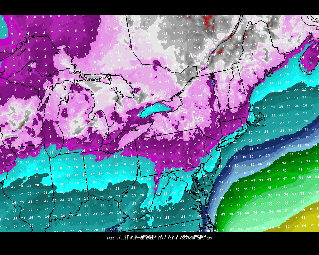
While this run may be slightly overdone in cold, the 4KM NAM shows bitterly cold temperatures being advected into the region tonight. (PSU E Wall)
The wind direction coming purely from the north via a 1040mb high (strong cold air source) leads to forecast very cold temperatures tonight — dropping into the mid teens in the City, and perhaps upper single digits to around 10 in northern and northwestern suburbs. There won’t be any true radiational cooling, however, due to the strong winds, so temperatures may tend to run a bit more uniform tonight.
Some data indicates the initial slight chance for a snow shower tonight as temperatures aloft drop more than they do at the surface initially, creating some instability. However, we feel that the strong high pressure system will create enough subsidence to limit any snow shower activity, except for areas further north and west with a bit more elevation/orographic lifting.
https://www.nymetroweather.com/wp-content/uploads/2024/02/Empire-2000-x-300-px-2.png00Doug Simonianhttps://www.nymetroweather.com/wp-content/uploads/2024/02/Empire-2000-x-300-px-2.pngDoug Simonian2014-03-05 14:59:112014-03-06 03:10:09Cold tonight and tomorrow, otherwise a relatively quiet week in weather
Hi friends! Our website uses cookies to provide an optimal browsing experience for you. New "Cookie Consent" laws mandate us to inform you of this. As long as you're cool with it, just hit OK. You'll only see this message once.
We may request cookies to be set on your device. We use cookies to let us know when you visit our websites, how you interact with us, to enrich your user experience, and to customize your relationship with our website.
Click on the different category headings to find out more. You can also change some of your preferences. Note that blocking some types of cookies may impact your experience on our websites and the services we are able to offer.
Essential Website Cookies
These cookies are strictly necessary to provide you with services available through our website and to use some of its features.
Because these cookies are strictly necessary to deliver the website, refusing them will have impact how our site functions. You always can block or delete cookies by changing your browser settings and force blocking all cookies on this website. But this will always prompt you to accept/refuse cookies when revisiting our site.
We fully respect if you want to refuse cookies but to avoid asking you again and again kindly allow us to store a cookie for that. You are free to opt out any time or opt in for other cookies to get a better experience. If you refuse cookies we will remove all set cookies in our domain.
We provide you with a list of stored cookies on your computer in our domain so you can check what we stored. Due to security reasons we are not able to show or modify cookies from other domains. You can check these in your browser security settings.
Other external services
We also use different external services like Google Webfonts, Google Maps, and external Video providers. Since these providers may collect personal data like your IP address we allow you to block them here. Please be aware that this might heavily reduce the functionality and appearance of our site. Changes will take effect once you reload the page.
-2")