Technical Discussion: Snowstorm Early Next Week

The winter that never ends continues into March with a large snowstorm taking aim on our area once again. After taking a closer look at data this afternoon and getting a better understanding of how this storm will develop, confidence is increasing in the fact that another plowable snowstorm will impact the northeast Sunday into Tuesday morning (March 2nd-4th). The worst of the storm is expected to occur throughout the day on Monday.

One of the driving mechanisms bringing back the arctic air and the stormy weather is the MJO. This phenomena monitors convective storms that form around the world and is divided into eight phases. Phases 8-1-2 in the month of March, which is the current and foreseeable state of the MJO, bring colder than normal and stormy weather to the eastern U.S. This is one of the reasons why the drought-stricken state of California is finally able to see rain over the next few weeks.
The MJO is not the only signal jump starting our winter pattern. The EPO, as has been the case most of this winter, is back in a negative state and trending even further negative (near -4 value) by this weekend. This means blocking in the eastern Pacific, including Alaska and western Canada has formed. Additionally, the AO is also negative which does not surprise me given the extreme negative state of the EPO and the arctic air mass we are currently dealing with and will still have to deal with for the next 10 days.

Wednesday’s light snow gives way to near record cold

Light snow is falling throughout the area this morning and will continue to do so for the next several hours. The culprit is a weak mid level disturbance and associated elongated surface low, which in actuality is quite progressive and weak. But sufficient lift for precipitation and the presence of markedly colder air will set the table for a very light snow event through Wednesday evening. Accumulations will be quite light, thanks to the transient and light nature of precipitation and still relatively warm ground temperatures, ranging from a trace to 1″ in some isolated areas. The snow is expected to wind down by later Wednesday afternoon.

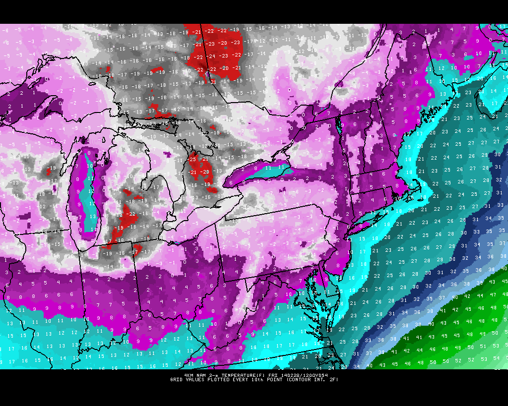
More notable than the light snow accumulations will be the impending shots of cold air, which will move from Canada and the Great Lakes into the Northeast on Thursday and Friday. A piece of the displaced Polar Vortex will shift southeastward toward Southeast Canada, and the resulting arctic front will drag anomalously cold air into the area behind Wednesday’s weak storm system and another clipper on Thursday. Temperatures aloft, at the 850mb level to be specific, will fall below -20 C in much of the area. Compare that to the +15 c temperatures at 850mb which reached the area last Friday, and you have yourself an idea as to how cold the airmass really is.

High resolution NAM model forecasting low temperatures in the single digits to near zero in the area on Friday morning.

High resolution NAM model forecasting low temperatures in the single digits to near zero in the area on Friday morning.

Read more

Cold, with nuiscance-type snow events this week

So far this winter, nearly every potential winter weather event has turned into something much larger than originally anticipated. This has created headaches and long work nights for meteorologists and forecasters alike. This week, we look to buck the trend a bit. A parade of disturbances through the mid levels of the atmosphere look likely to bring opportunity for light snowfall, but the progressive nature of the pattern will ultimately keep these events fast, with no significant or heavy precipitation and generally weak low pressure centers.

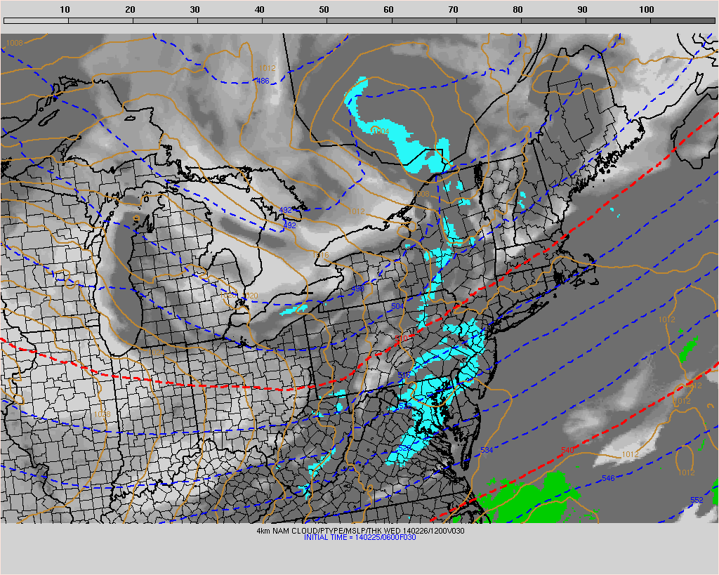
The result will be multiple periods of light snow, first on Tuesday afternoon and evening especially across Southeast New Jersey. Additional periods of light snow are expected both Wednesday afternoon (area-wide) and Thursday (mostly across northern zones). But when all is said and done, the general theme will be light accumulations only (generally a trace to 1″), as the intensity and duration of the snow will be far too light to cause any significant issues. Still, roads could become slick for a period of time so as always we advise traveling with caution. There are no signals for banding or areas of heavy precipitation that could surprise us.

NAM model forecasting light snow/snow showers to impact the area on Wednesday (similar impacts expected Tuesday).

NAM model forecasting light snow/snow showers to impact the area on Wednesday (similar impacts expected Tuesday).

Read more

Cold air filters in, light snow likely this week

Temperatures fell back towards normal on Monday (it wasn’t hard to notice the lack of warmth and return of colder wind), with highs generally only reaching the mid to upper 30’s throughout the area. While this certainly felt more chilly than what we experienced this weekend, the real chill is still on the way this coming Tuesday and is expected to continue through the week. More interestingly, a parade of disturbances is likely to traverse the country from the Pacific northwest towards the East Coast, providing multiple opportunities for wintry precipitation in the area.

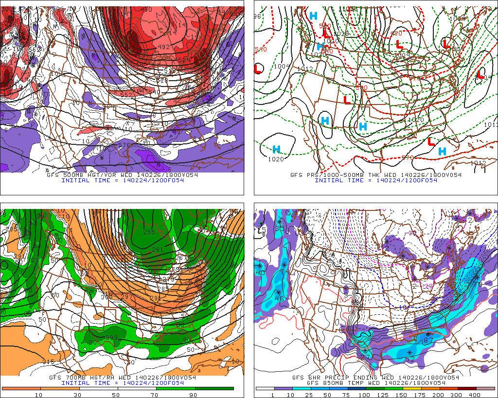
The main difficulty in the forecast will be the exact track of these systems, owing to the positioning of the Polar Vortex which is forecast to remain parked over Southeast Canada. This positioning allows for plentiful cold air, but also suppresses the baroclinic zone and favored storm track to our south. Forecast models, picking up on this and the southward sag of the arctic front, have trended farther south and east with the storm system forecast to track near the East Coast on Wednesday — the first in the parade. Currently, light snow still seems likely due to favorable jet streak positioning, but the heaviest precipitation is expected to remain offshore.

GFS model showing Wednesday's potential system passing mostly seaward.

GFS model showing Wednesday’s potential system passing mostly seaward.

Read more