Windy, cooler behind major cold front

An energetic and powerful storm system moved through the Central and Eastern United States on Sunday, causing widespread severe weather. More than 50 reported tornadoes and 500 reports of damaging winds were received by the Storm Prediction Center behind powerful severe thunderstorms throughout the Great Lakes and Ohio Valley. The cold front moved quickly eastward through the Northeast states, bringing strong thunderstorms through the NYC Metro area just after 430am on Monday morning. Gusty winds were observed at many reporting stations as the storms moved through.

Monday will be a day of change to start the new work week, as the aforementioned cold front slides off the coast. Westerly winds will begin in earnest, gusting over 25 miles per hour at times during the day on Monday. Warm sun will allow temperatures to climb into the mid to upper 50s, but the airmass aloft will be rapidly changing. Dropping humidity and strong winds will be the first signs of the change. By Monday evening into early Tuesday morning, temperatures will fall into the 30s (colder inland). Highs on Tuesday will only reach into the 40s.

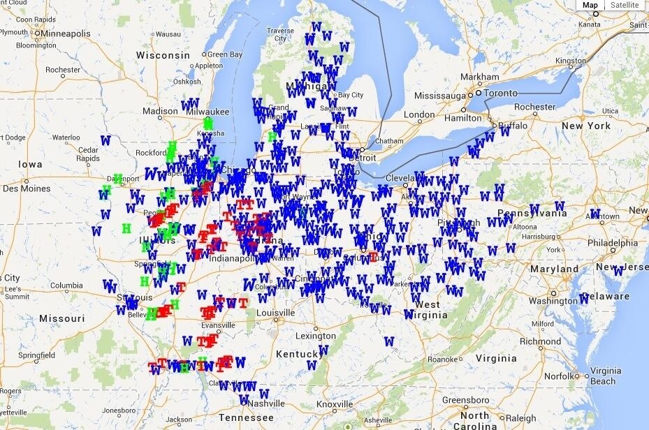
Severe weather reports (Tornado, Wind, Hail) from Sunday through early Monday morning.

Severe weather reports (Tornado, Wind, Hail) from Sunday through early Monday morning.

Read more

SPC issues rare High Risk over Great Lakes, Ohio Valley

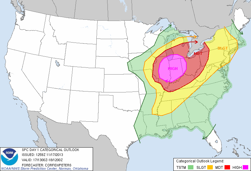
A major severe weather outbreak is forecast this afternoon across much of the Great Lakes and Ohio and Mississippi Valleys. The Storm Prediction Center has issued a rare “High Risk” for severe weather across much of Illinois and Indiana as well as parts of Southern Michigan and Western Ohio. A highly unstable atmosphere, juxtaposed with an impressive storm system both aloft and at the surface, will act to trigger the development of impressive late-season severe thunderstorms. Impressive low level shear and wind turning will allow for the potential of widespread tornadoes, some of which could be violent. With time, the storms will organize to pose more of a damaging wind threat as they shift eastward towards the Ohio Valley. For more on the developing threat, stay tuned to the Storm Prediction Center page which will display all outlooks, watches and warnings.

In our area, the SPC has extended a “Slight Risk” for severe weather to include all of New Jersey, New York and Connecticut. As the associated cold front sweeps through the Ohio Valley and eventually the Northeast US later today, the potential for isolated strong wind gusts is expected to continue. The threat, and intensity of the storms, is not expected to be nearly as severe as it will be back across the Great Lakes and Ohio Valley.

Storm Prediction Center Day 1 Categorical severe weather outlook from 11/17/13, showing a High Risk over parts of IL, IN and OH as well as a Slight Risk in the NYC Area.

Storm Prediction Center Day 1 Categorical severe weather outlook from 11/17/13, showing a High Risk over parts of IL, IN and OH as well as a Slight Risk in the NYC Area.

Read more

Warm weekend, severe weather to our west

Warmer weather settled into the area this morning behind a warm front, which moved northward as a result of a strong system over the Central United States. The warm weather comes on the heels of some of the coldest weather so far this season, which swept through the Northeast on Tuesday. The snow and cold seems like an afterthought at this point, with temperatures well into the 60’s and plenty of sun. But a progressive pattern in the mid and upper level of the atmosphere means the changes will continue.

For the remainder of Saturday, the main idea will be pleasant and dry. Temperatures will undoubtedly cool down with sunset (which is starting to come at an even earlier hour as we approach later November). But southwest winds, which will become increasingly apparent ahead of a cold front on Sunday, will keep the air much warmer than it has been over the past several nights. Lows will only fall into the 50’s in urban areas — and we’ll dodge a few scattered showers as well.

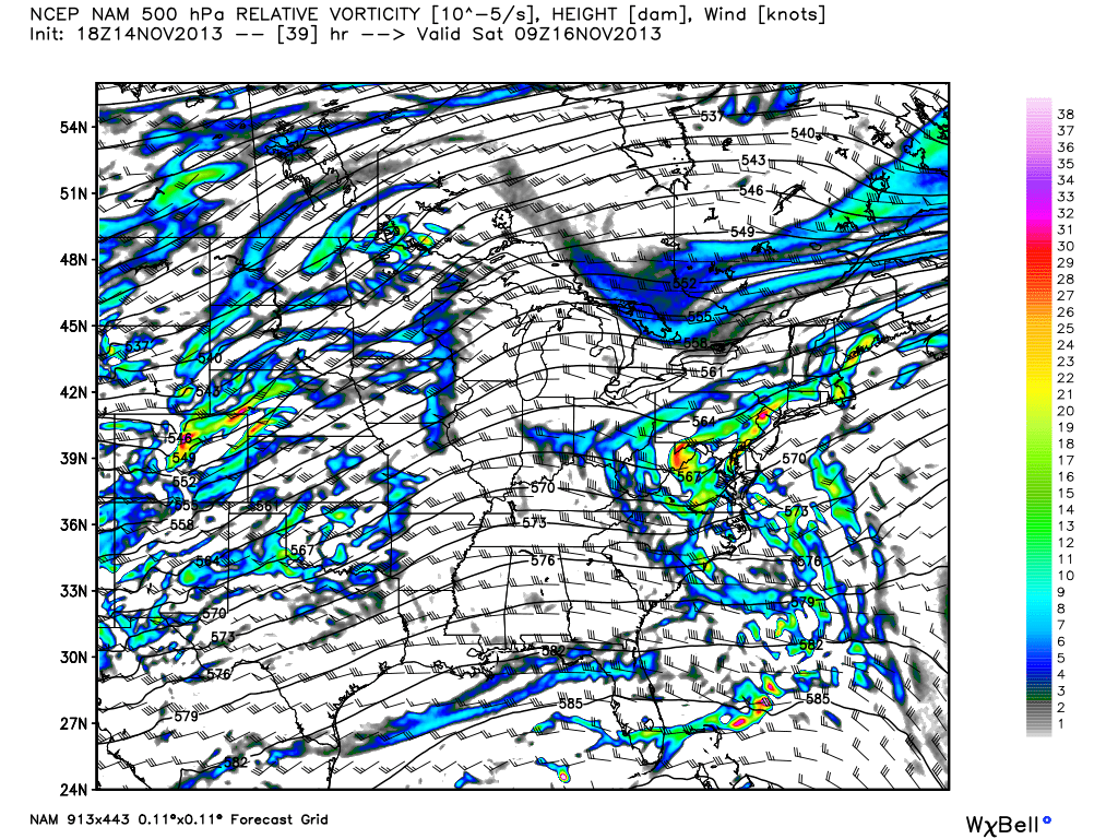
NAM model showing a significant mid and upper level disturbance moving through the Central US on Sunday.

NAM model showing a significant mid and upper level disturbance moving through the Central US on Sunday.

Read more

Weekend warmup will feature unsettled weather

Much has been made of the cold and snowy weather this week, and rightfully so. Temperatures fell into the teens and 20’s on Wednesday night after snow on Tuesday, and high temperatures Wednesday afternoon barely scraped into the upper 30’s. Those temperatures are more typical for overnight lows this time of year. But there is another story line in the weather pattern, and it is one that will certainly keep appearing until there is a large scale change: the pattern is progressive. In the mid and upper levels, the pattern shows no signs of slowing down, meaning any airmass that settles into the area (no matter how anomalous) won’t meander around for long.

Not surprisingly, the very cold air which moved through the area early this week is well out of the picture. Temperatures will warm into the upper 50’s on Friday and the warming trend will continue through the weekend. Along with the warmup, unfortunately, will come some unsettled weather. As a mid level ridge builds over the Central and Eastern US, multiple disturbances will ride eastward through the Mid Atlantic states. The result, in terms of sensible weather, will be increased potential for clouds and showers on both Saturday and Sunday — but not a washout.

NAM model showing multiple disturbances moving into the Mid Atlantic states this weekend. Image courtesy weatherbell.

NAM model showing multiple disturbances moving into the Mid Atlantic states this weekend. Image courtesy weatherbell.

Read more