Cold start, slowly warming this week

The growing season ended early Monday morning throughout much of the interior, down to the immediate suburbs of Western Union and Essex counties. The winds kept radiational cooling from performing too well, however, and much of the 5 Boros of NYC remained above freezing — so the growing season will technically continue there until the next freeze. Although it may seem very brisk today (temperatures will struggle into the 50’s Monday afternoon), the cold air will be rather brief. Temperatures are expected to slowly warm this week, with highs reaching into the 60’s by later this week ahead of a cold front. The roller coaster of temperatures has been a trend of late, with a similar event occurring last week ahead of a front and storm system.

HRRR model showing dew points in the teens throughout the area on Monday afternoon.

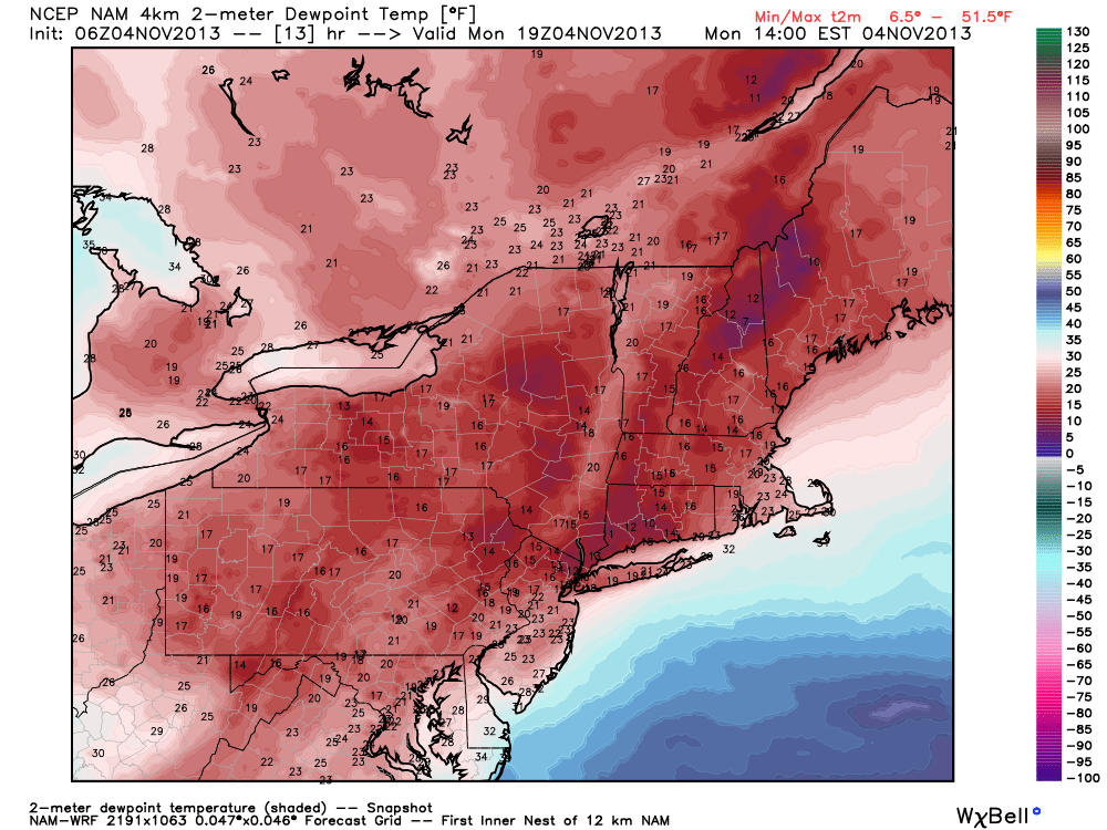
HRRR model showing dew points in the teens throughout the area on Monday afternoon. Courtesy Weatherbell.

Read more

Forecast: Warmer, strong winds possible Friday

For the first Halloween in three years, the weather hazards in our area will be kept to a minimum. After a damaging snowstorm in 2011, and the recovery from Hurricane Sandy in 2012, today’s weather will feel like a major relief. Additionally, it will feel like the top of a week-long roller coaster of temperatures. Highs today will top out in the upper 60s to lower 70s, but the humidity will make it feel muggier than it has been in several weeks. A few showers are possible across the north and western suburbs later this evening.

Water Vapor Satellite imagery from the morning of 10/31/13, showing moisture streaming towards the area ahead of a storm over the Central US.

Water Vapor Satellite imagery from the morning of 10/31/13, showing moisture streaming towards the area ahead of a storm over the Central US.

Read more

PM Update: Pleasant, warming trend begins midweek

The cooler than normal weather which has dominated the pattern over the past week or so will take a brief respite over the next few days, as a storm system surges towards the Central US and brings a warm front towards the region. In the meantime, pleasant weather is expected tonight — with temperatures falling from the middle 50s into the 40s overnight.

NAM model showing high temperatures in the middle to upper 60's throughout the area on Halloween (Thursday).

NAM model showing high temperatures in the middle to upper 60’s throughout the area on Halloween (Thursday).

Read more

Forecast: New week starts cool, ends warm

Our Hurricane Sandy Anniversary Archive is now available.

The new work week began with another in a series of colder than normal mornings, as low temperatures fell into the upper 20s and lower 30s across much of the interior on Monday morning. The city and urban areas remained a bit warmer, although still chilly, with lows dropping near 40 degrees. Monday will turn out to be a pleasant autumn day, as temperatures warm into the upper 50’s to lower 60’s by afternoon. A light southwest breeze will make it feel plenty comfortable, and less chilly than the past several days which featured windier and cooler conditions.

Northeast US Surface Analysis and observations from the morning of October 28, 2013 showing high pressure in control and a cold front approaching.

Northeast US Surface Analysis and observations from the morning of October 28, 2013 showing high pressure in control and a cold front approaching.

A cold front dropping southward through New England, however, will provide a reinforcing shot of cooler air by later Monday. Associated with a disturbance over Southeast Canada, the front isn’t expected to feature any precipitation. The wind shift, however, will be noticeable. By Tuesday, winds will have swung around once again behind the front, and will be blowing out of the north. High temperatures will once again struggle into the lower to middle 50’s — making Monday seem like a much warmer day in comparison.

Read more