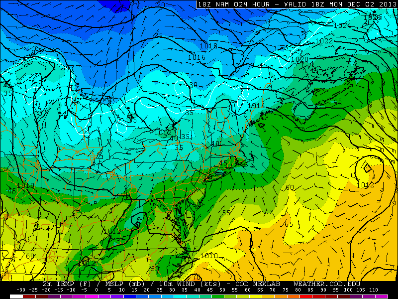
Cold weather has become a staple in the area forecast over the past several days, with the only warmup coming during a significant storm system — which produced the first rainfall of over 1″ since September in New York City. Otherwise, though, it has been a cold and dry pattern which has dominated the past several weeks. Some changes are in order during this week, but the start will be characterized by a slight warmup. Monday will be the first of a few “warmer” feeling days, with highs in the 40’s to near 50 in many spots as well as plenty of sun.
During the week, the airmass will slowly modify as a high pressure continues to control the pattern. High temperatures will reach into the upper 40’s and lower 50’s by the middle to second half of the work week. With the warmup, will come a chance of precipitation and the likelihood of clouds, which will move into the area as a warm front moves nears on Thursday.
NAM model, forecasting high temperatures in the upper 40’s to lower 50’s on Monday.
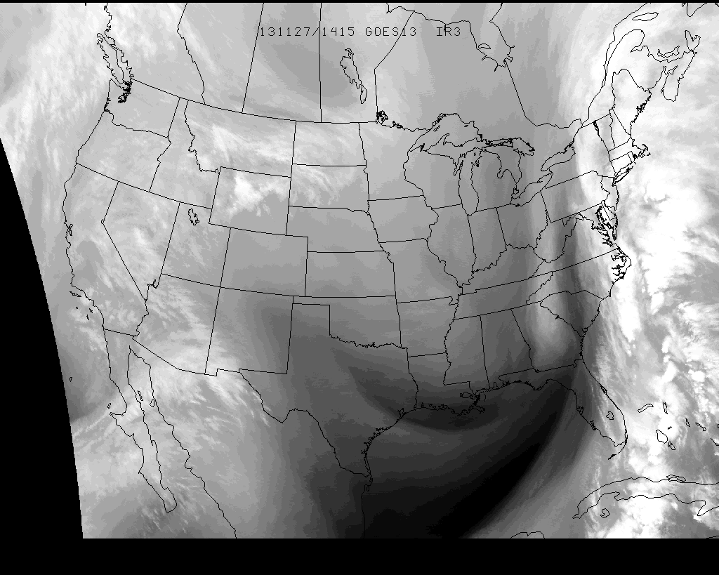
A dynamic and complex storm system (not a nor’easter by definition despite the efforts of some to call it such) continued to menace the East Coast early on Wednesday, during one of the biggest travel days of the year. Significant delays were reported this morning at several area airports, owing to the strong winds and heavy rain. Through this afternoon, periods of heavy rain are expected to continue. The center of low pressure has moved north and east of the area into Southern New England, but lower pressures extending southward and a noticeable thermal boundary will serve as a “highway” for continuing rainfall.
With time, however, this boundary will shift eastward and the low pressure center will shift north/northeast. The most noticeable effect of this will be the temperature and wind shift. Warm temperatures from earlier this morning (60’s observed throughout much of New Jersey and even into New York City) will become a distant memory as westerly winds behind the aforementioned thermal boundary will usher in colder air. Temperatures are forecast to fall back into the 40’s by later today, and 20’s and 30’s overnight tonight. Snow showers cannot be ruled out by later this evening throughout the area in the wake of the strengthening low pressure center. The heaviest rain is expected to wrap up by mid-afternoon, but will linger into the evening across areas North and East of NYC.
Water vapor satellite imagery from Wednesday 11/27/13, showing a tropical moisture fetch with a storm system in the Eastern US.
https://www.nymetroweather.com/wp-content/uploads/2024/02/Empire-2000-x-300-px-2.png00John Homenukhttps://www.nymetroweather.com/wp-content/uploads/2024/02/Empire-2000-x-300-px-2.pngJohn Homenuk2013-11-27 10:25:442013-11-27 10:25:44Complex storm system wraps up later today
A pre-thanksgiving storm system will create a travel nightmare from Tuesday Night through Wednesday, providing a myriad of threats up and down the east coast. Before we dive into the details of the storm system, what’s causing it to occur, and what you can expect in our area, we can lay out a few things we know as fact as of Tuesday morning. First, there will be significant travel delays on Wednesday. If you’re driving, flying, or using some other form of travel in the Mid-Atlantic or Northeast US, expect delays…likely significant. Second, Thanksgiving day itself won’t be all that bad. So once you make it where you need to be, the weather for actual Turkey Day looks to be fairly pleasant, albeit a bit cold. In our post below, we break down the storm system and what you can expect from it.
Visible satellite imagery from Tuesday morning, showing a significant storm system forming in the Southeast US.
What’s the deal, how is this storm forming?
Two pieces of energy in the jet stream across the Central and Eastern United States will phase on Wednesday, essentially very close to our forecast area. A low pressure area will develop from the Southeast States northeastward into New England. As it does so, warm air will stream up the Eastern Seaboard — as will significant amounts of precipitation in association with a strong low level jet and moisture transport. The low pressure system will then rapidly deepen as it moves to our north through New England and into Eastern Canada.
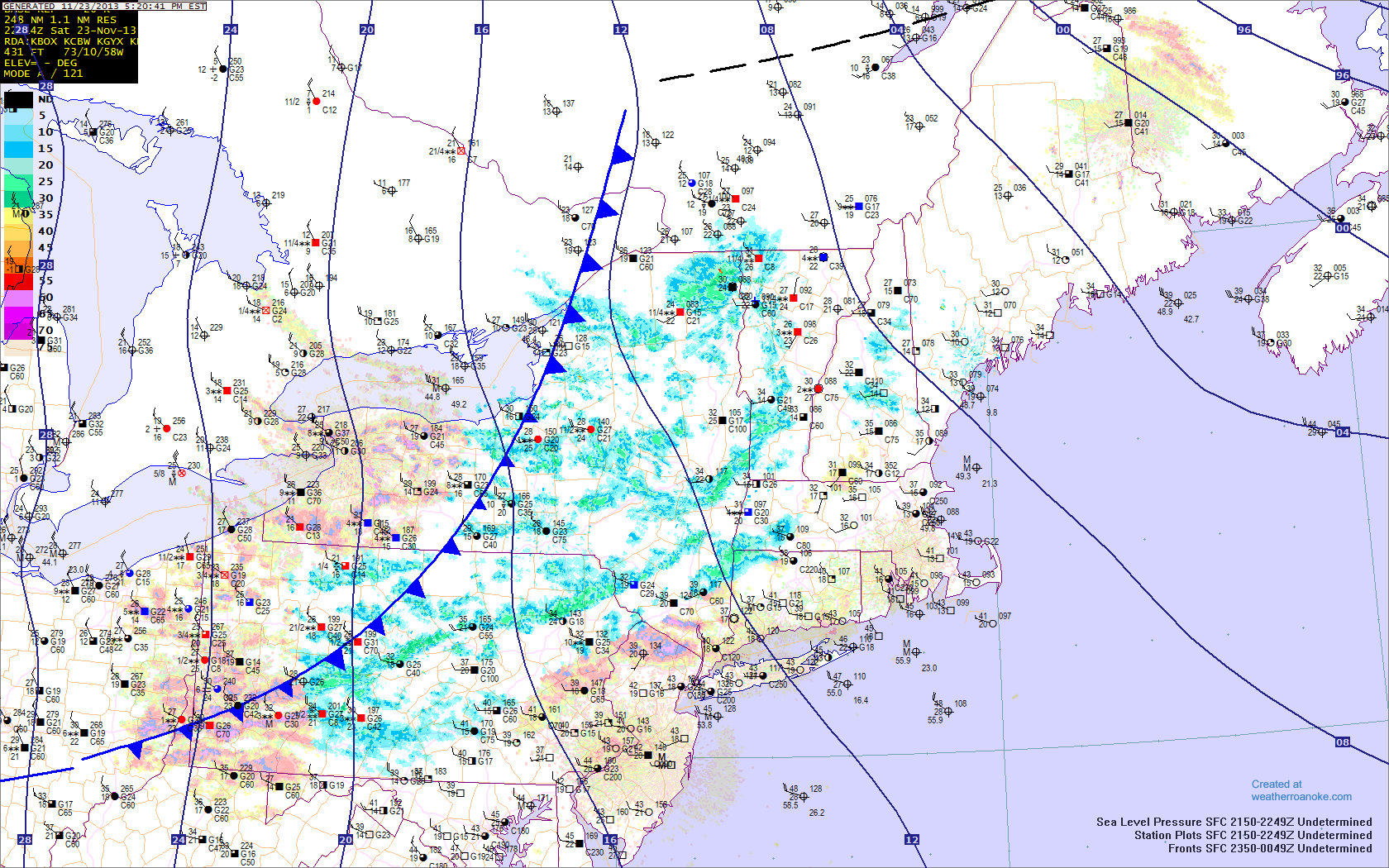
If you thought today was chilly, just wait until tomorrow. The much-advertised Arctic cold front is on its way, which will bring bitterly cold temperatures, and strong northwest winds. There may be a few scattered snow showers or snow flurries associated with this front, especially north and west of the city.
The Arctic front is approaching the region and will be crossing over the next few hours. Temperatures will plummet behind it. Additionally, snow showers can be found, indicated by the blue patches. Any snow showers should primarily remain north and west of the city. Image credit goes to weatherroanoke.com
Any snow showers should primarily remain to the west of the city, given that precipitation tends to dry out once it heads east of the Catskill and Adirondack mountains in a northwest flow. That being said, do not be surprised if a stray snow shower or two does survive a bit further east. Areas in NW Jersey may see a brief period of steady snow covering the ground and reduced visibilities, so any motorists should take caution if they run into this band of snow. Winds will also be gusty, further contributing to any loss in visibility.
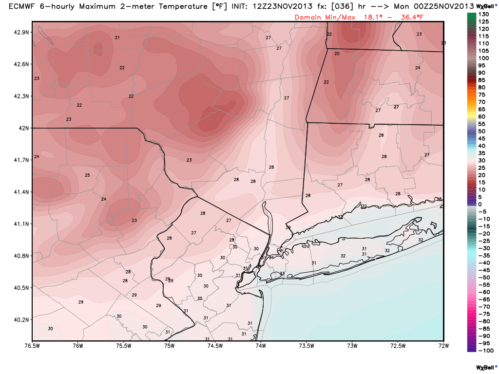
Temperatures will drop quickly this evening through the 30s, and our high temperatures tomorrow will actually be occurring at midnight, when temperatures will be in the mid 30s at midnight, and around 30 north and west. They will fall into the upper teens by morning north and west, with wind chills in the single digits, and mid 20s along the coast, with wind chills in the teens. Winds will be sustained between 20-25 miles per hour, with gusts around 35-40 miles per hour. Tomorrow, highs will only be in the upper 20s to lower 30s across the region, as seen in the image below.
Today’s 12z European model shows temperatures remaining below freezing tomorrow afternoon. Image credit goes to weatherbell.com
Winds will become even stronger tomorrow during the day, with winds sustained between 25 and 30 miles per hour, with gusts as high as 40-50 miles per hour. This will keep wind chills in the teens throughout the entire day. Make sure to bundle up!
https://www.nymetroweather.com/wp-content/uploads/2024/02/Empire-2000-x-300-px-2.png00Doug Simonianhttps://www.nymetroweather.com/wp-content/uploads/2024/02/Empire-2000-x-300-px-2.pngDoug Simonian2013-11-23 18:44:512013-11-24 01:25:21Arctic front on the way, heavy rain possible on Wednesday
Hi friends! Our website uses cookies to provide an optimal browsing experience for you. New "Cookie Consent" laws mandate us to inform you of this. As long as you're cool with it, just hit OK. You'll only see this message once.
We may request cookies to be set on your device. We use cookies to let us know when you visit our websites, how you interact with us, to enrich your user experience, and to customize your relationship with our website.
Click on the different category headings to find out more. You can also change some of your preferences. Note that blocking some types of cookies may impact your experience on our websites and the services we are able to offer.
Essential Website Cookies
These cookies are strictly necessary to provide you with services available through our website and to use some of its features.
Because these cookies are strictly necessary to deliver the website, refusing them will have impact how our site functions. You always can block or delete cookies by changing your browser settings and force blocking all cookies on this website. But this will always prompt you to accept/refuse cookies when revisiting our site.
We fully respect if you want to refuse cookies but to avoid asking you again and again kindly allow us to store a cookie for that. You are free to opt out any time or opt in for other cookies to get a better experience. If you refuse cookies we will remove all set cookies in our domain.
We provide you with a list of stored cookies on your computer in our domain so you can check what we stored. Due to security reasons we are not able to show or modify cookies from other domains. You can check these in your browser security settings.
Other external services
We also use different external services like Google Webfonts, Google Maps, and external Video providers. Since these providers may collect personal data like your IP address we allow you to block them here. Please be aware that this might heavily reduce the functionality and appearance of our site. Changes will take effect once you reload the page.
-2")