2.17 PM All Zones: Here comes the weekend warmth

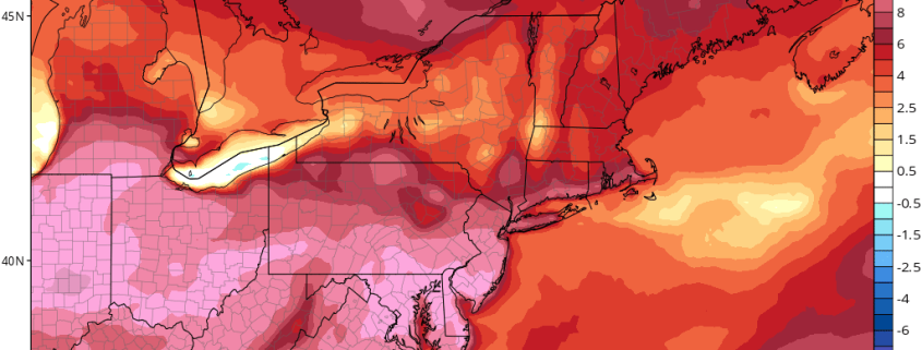
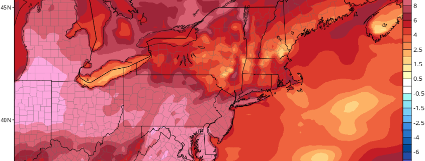
It’s been well discussed, well explained and well known for several days: It’s going to get quite warm this weekend. And now it’s finally here. Mid level atmospheric heights will continue to rise from this afternoon into this weekend as a large ridge, initially situated over the Western U.S.A coast, shifts eastwards and collapses. Warmer Pacific air will flood eastwards as well, reaching the Northeast U.S.A this weekend.

This very same air is already over the Plains and parts of the Great Lakes, where temperatures have surged into the upper 50’s and lower 60’s this afternoon. This air is highly anomalous for this time of year in those locations, especially the northern plains where temperatures are 15 to 20 degrees above normal averages!

Read more

2/17 Late AM All Zones Update: Unseasonably Mild Weather This Weekend

High pressure with mid-level ridging builds into the region today. This will support more sunshine, with just some high cirrus passing through at times. After a cold start this morning, temperatures will rise into upper 30s to lower 40s this afternoon. Northwest winds will lighter to today, as a deep low moves further out into the Atlantic. So won’t feel as cold this afternoon, as Thursday afternoon was.

Read more

2.16 PM Zones: Warm, tranquil weather on the way

The news we have all been waiting for is drawing closer and closer! The warmup and tranquil weather, which we have been discussing for a few days now, is on the way this weekend. In fact, it will begin as early as Friday, when heights in the mid levels of the atmosphere will begin to rise. We still have a cold and blustery day to get through today — and a chance of snow showers with blustery winds will continue through the afternoon.

These will dissipate through the early evening hours and temperatures will remain quite cool tonight throughout the area. Lows are expected to drop from the upper teens through the 20’s in the entire region, with the warmest temperatures remaining near the coast and in the typically warmer urban areas such as New York City and Newark.

Read more

2/16 AM All Zones Update: Cold & Blustery Today…Warmer This Weekend

A strong closed low, which brought some heavy snow to parts of Northern New England, will support cold and blustery conditions. High temperatures will be in the middle to upper 30s. Northwest winds could gust to between 30mph to 40mph today. Skies will be partly sunny with highs in middle to upper 30s. Some instability and a weak upper-level disturbance will move through today. So some isolated snow showers or flurries can’t be ruled out, especially for the Interior.

Read more