Offshore Storm Brings Snowfall for Coastal Areas Today

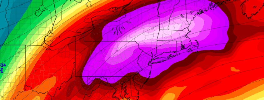
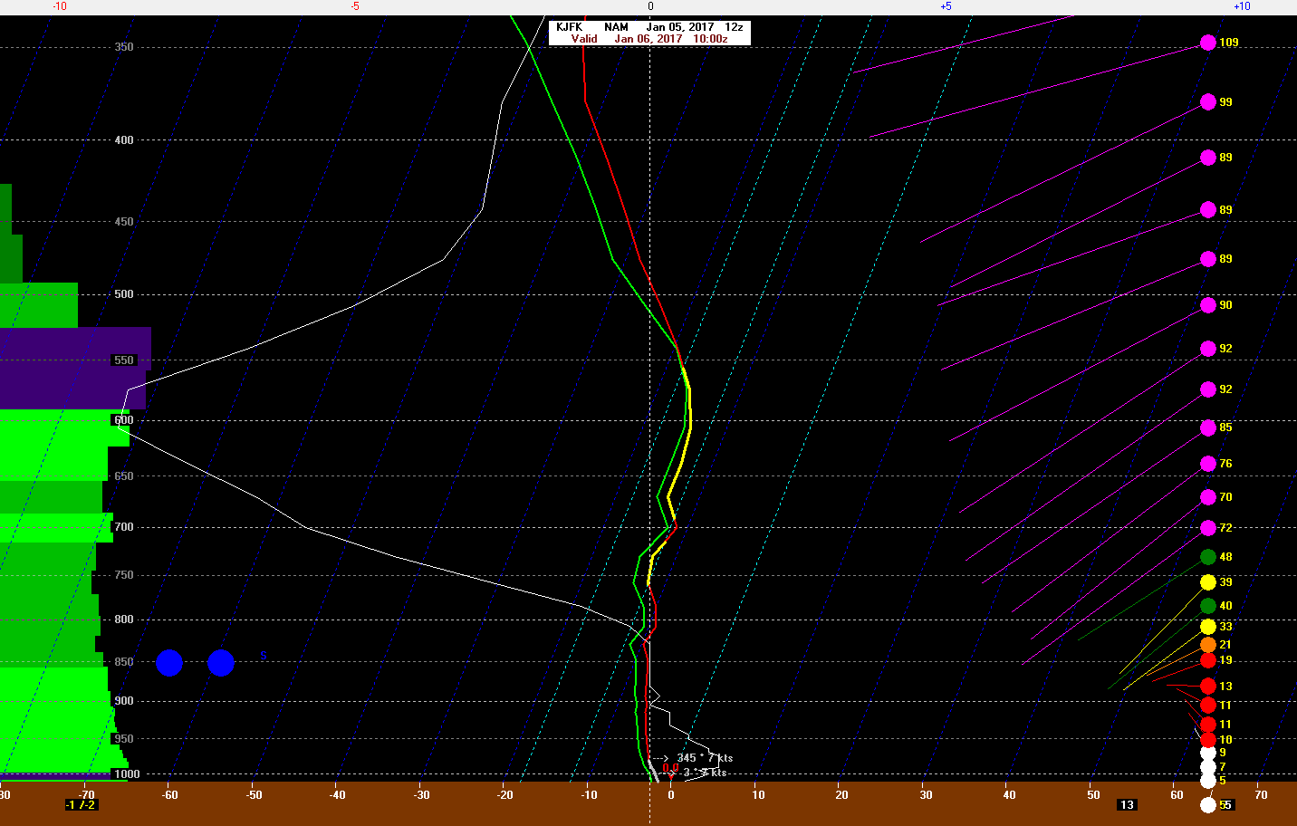
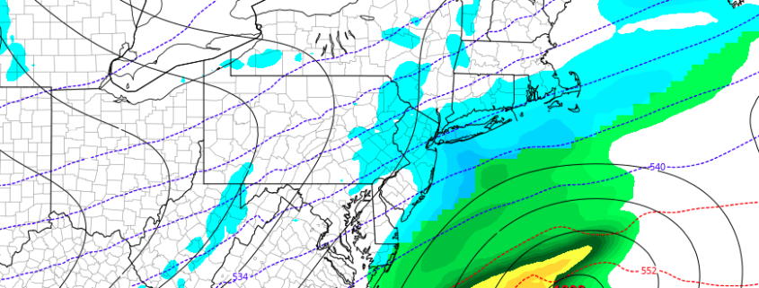
Low pressure off the Southeast coast early this morning, will track quickly northeast today. Snow will overspread from the southwest to northeast across most of the region this morning.  The low will slowly intensify today and have a lot moisture from the Gulf of Mexico and Atlantic Ocean. But the low track well south and east of 40/70 benchmark. This will keep the brunt of the storm mostly offshore.

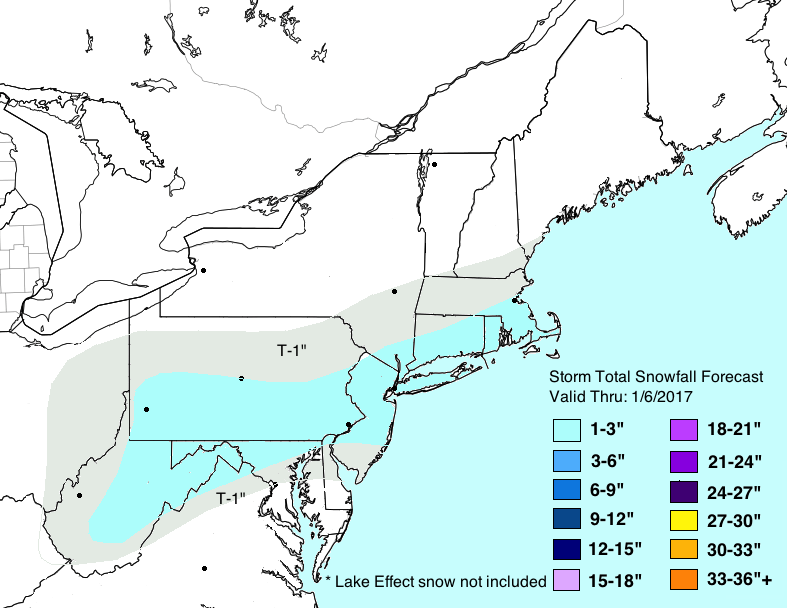
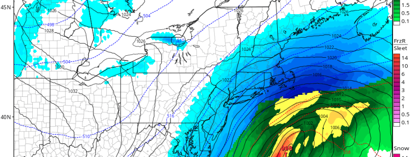
However, lift from upper-level jet and mid-level disturbance are anticipated to enhance some moderate to possibly heavy banding over snow particularly for coastal sections by early this afternoon. Heaviest snowfall is expected over parts of Central and Eastern parts of Long Island and Connecticut and over Southeast NJ where 6” of snow and greater is mostly likely fall. The National Weather Service has issued Winter Storm Warnings for these areas.

snowtotalsmap

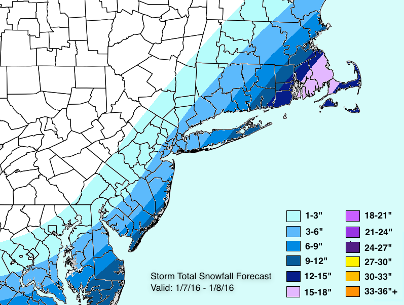
Snowfall map issued Friday night

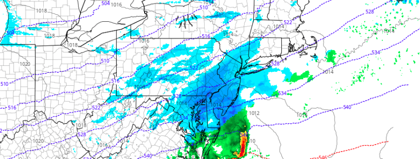
Further northwest, latest guidance early this morning, indicates some low-level dry air with north-northwest winds may cause sharp cut-off in snowfall totals especially just of west of the Hudson River. At this time, we continue anticipate about 3″-6″ for NYC and Nassau and back towards I-95. Just northwest of these locations, snowfall totals will drop off quickly. But if low-level dry air wins out, these amounts may be lower  with far less snow farther northwest We will keep monitoring for these trends today and update as necessary. Otherwise mostly cloudy skies are expected today with high temperatures in the lower to middle 20s.

Snow will begin tapering off late this afternoon and this evening, as the storm moves further into Atlantic. It will turn colder behind this storm temperatures dropping into teens over region overnight. Skies will clear later tonight, as high pressure builds into region. Sunday will be partly sunny, but very cold, blustery with highs in the middle to upper 20s.

Significant snowstorm likely near the coast on Saturday

The rollercoaster with the model runs has continued today, with regards to Saturday’s winter storm. However, for the most part, guidance continues to trend west, and there are some reasons to believe that will continue. There is still a limit as to how far west this can go, though, and the cutoff to the west looks pretty sharp, so this may only be a “major” snowstorm for Eastern Long Island. Still, it’s looking like a snowier Saturday than first thought a few days ago.

Generally speaking over the past few days, the models have become much more impressive with the strength of the initial shortwave that entered the US from the Pacific. It’s now in the southern stream and tapping into a lot of Gulf of Mexico moisture, leading to some strong thunderstorms in the deep South. Sometimes what happens here is that once the models realize that there is plenty of convection going on, the latent heat in the atmosphere increases, which leads to higher heights along the East Coast and thus further northwest shifts. This appears to be happening in today’s model guidance.

Read more

Light Snowfall Likely Tonight into Early Friday

A polar shortwave disturbance will cause low pressure to develop along the North Carolina coast this evening, with a low pressure area slowly intensifying and tracking to the northeast. The storm system will remain relatively progressive, with the brunt of its precipitation remaining over the Atlantic Ocean.

However, with some lift fro, an upper-level jet streak overhead, snow is likely to spread throughout parts of the Mid Atlantic and Southern New England later tonight into Thursday morning. Most of the snow is expected to fall on the lighter side of the intensity scale, with liquid totals only expected to reach .10″ – .25″.

However, instability and large omega (lift) in the snow growth region will likely to lead to the formation of large dendrites. Snow ratios from this event could be as high as 20 to 1 in some areas. With that in mind, snowfall totals of 1-3″ are expected throughout much of the region. Roads could be slick or snow covered for Friday’s morning commute.


4km NAM model sounding for JFK airport showing large dendrite snow growth

4km NAM model sounding for JFK airport showing large dendrite snow growth

Some lower amounts are possible well inland where moisture will be more limited. Heavier banding may occur closer to the coast, especially over the NJ coast and Long Island with the potential for isolated totals upwards of 3”.  Snow will taper off Thursday morning as low pressure moves away from the region. Clouds will break for some sunshine in the afternoon as drier moves into the region.

Storm Total Snowfall Forecast updated January 5th, 2017

Storm Total Snowfall Forecast updated January 5th, 2017

Another storm threatens the region this weekend — more details on that coming tonight for Premium members.

AM All Zones Update: Coastal storm scrapes by Friday

Cool, crisp, and windy conditions are likely to be the dominant weather today as high pressure builds into the area and arctic air surges through as well. The cold start to the day will continue well through the afternoon hours as high temperatures remain below seasonal averages throughout the area. Blustery winds are expected as well, as mixing and steep lapse rates help mix down some winds aloft.

As we move towards Friday, the focus will turn towards a polar disturbance which will drop southwards from Canada into the Mid Atlantic States. While the atmosphere will be cold and dry initially, a gradual increase in moisture and lift in the atmosphere is expected from late Thursday Night into early Friday morning. Clouds should increase from southwest to northeast.

Read more