VIDEO Analysis: Potential Heavy Snow on Wednesday

The very active pattern for early March will continue, as we are tracking yet another potential major storm system that would impact the area on Wednesday. The large -NAO blocking pattern will continue, which will force multiple potent, dynamic disturbances to our south, and with the airmass a bit colder this time around compared to the Friday’s storm, snow — potentially heavy — is a much bigger threat for the NYC area.

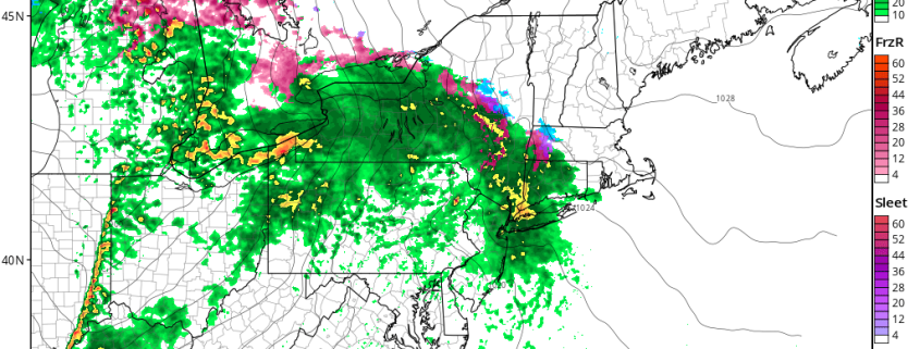
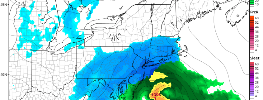
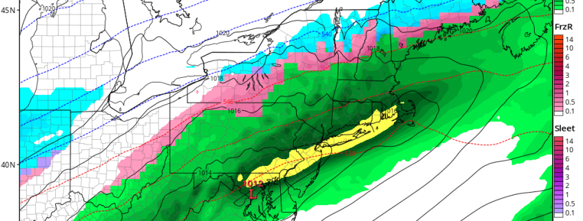
In our latest video, we discuss Sunday’s 12z ECMWF (Euro), Sunday’s 18z GFS, and Sunday’s 18z NAM. The Euro is the furthest east solution, which would only give significant snow for Long Island and Southern New England, the GFS is the furthest west solution, which would give the immediate I-95 suburbs a significant snowfall, but areas further southeast more rain and subsidence, while the NAM is the snow-lover’s ideal “in between”, which hits the entire NYC Metro region with a heavy snowfall. Not only is the NAM model “in between”, but it is also the most dynamic of the three solutions, maturing its mid-level centers earlier. If this were to occur, the storm would slow down just off the coast, and bring in a heavy band of snow for a long period of time.

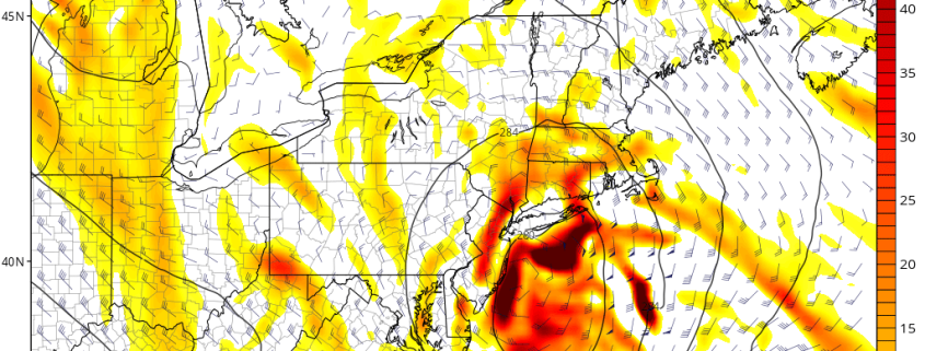
This storm is an interesting case, because it could track very close to the coast, which would normally mean a rain event. However, with the circulation very compact and dynamic, more northerly winds would “rush” in towards the center of the storm than is usual, so the banding could be more compact and stronger closer to the coast, and temperatures could also be much colder than what is “typical” for a storm track of this nature.

We also discuss why each model is portraying the scenarios they are, as well as which we believe is most likely to occur in this pattern.

Friday Briefing: Wet Weather for the Weekend, Early March Nor’easter?

Happy Friday! Today will continue to feature more cloudiness, chilly temperatures, and raw weather, as a frontal boundary continues to remain to the south. Periods of rain are likely with a weak frontal system moving through the Northeast. Most of this rain will be on the light to moderate side. In some of the higher elevations over the Northwest Hudson Valley and New England, surface temperature may support some spotty areas of freezing rain, which could make for some slippery spots on roads. But otherwise no significant weather hazards are anticipated today.

Read more

Video Analysis: Saturday Night Snow Threat

Good evening! Despite a large sea of warmth expected in the next general 7-10 days, there is a quick shot of cold that will be arriving on Saturday, and a storm system may quickly follow. It may just so happen that this storm will arrive just in time to tap into this quick shot of cold air, and thus deliver an accumulating snow event on Saturday night, and perhaps significant.

Our latest video analyzes this snow threat, and talks about the features that support snow, and the features that do not support snow. In a broad sense, the pattern is very fast-moving and progressive, which typically prevents a large amount of amplification. When combined with a compressed flow from a strong Polar Vortex in Central Canada and a strong Southeast ridge, that may serve to keep the storm weak and sheared out to the south.

However, the initial energy entering the US looks very potent, and a strong temperature gradient with a surge of moisture from the Gulf does support a heavy axis of precipitation developing from the Tennessee Valley and into the Northeast. If everything comes together, a widespread area of 6-10″ of snow would be possible from DC to Boston. But this is a “thread the needle” situation, where it is easily conceivable that the fast-moving flow will shear out the storm system, but also the strong Southeast ridge and departing high pressure (remember, this is a quick cold shot!) will allow for a warmer scenario with more rain to unfold.


Friday Briefing: Moderating Temperatures & Rain This Weekend for the Northeast

Good morning and happy Friday! High pressure slides just offshore with a return southerly flow into the Northeast states today. This flow will help temperatures to moderate a bit as the morning goes on, but sunshine will begin to fade behind increasing clouds. A low pressure system approaches with a warm front moving east from the Ohio Valley into the Northeast states, signaling the approach of a transient storm system today.

Read more