Dangerous hurricane Laura quickly approaching TX/LA coasts

Hurricane Laura strengthened into a major Category 3 hurricane this morning, and the system is still strengthening as of early this afternoon. The National Hurricane Center forecasts the storm to make landfall as a powerful Category 4 hurricane from later tonight into Thursday morning. The storm will pose a significant threat to life and property along the Texas and Louisiana coasts.

Latest observations and trends

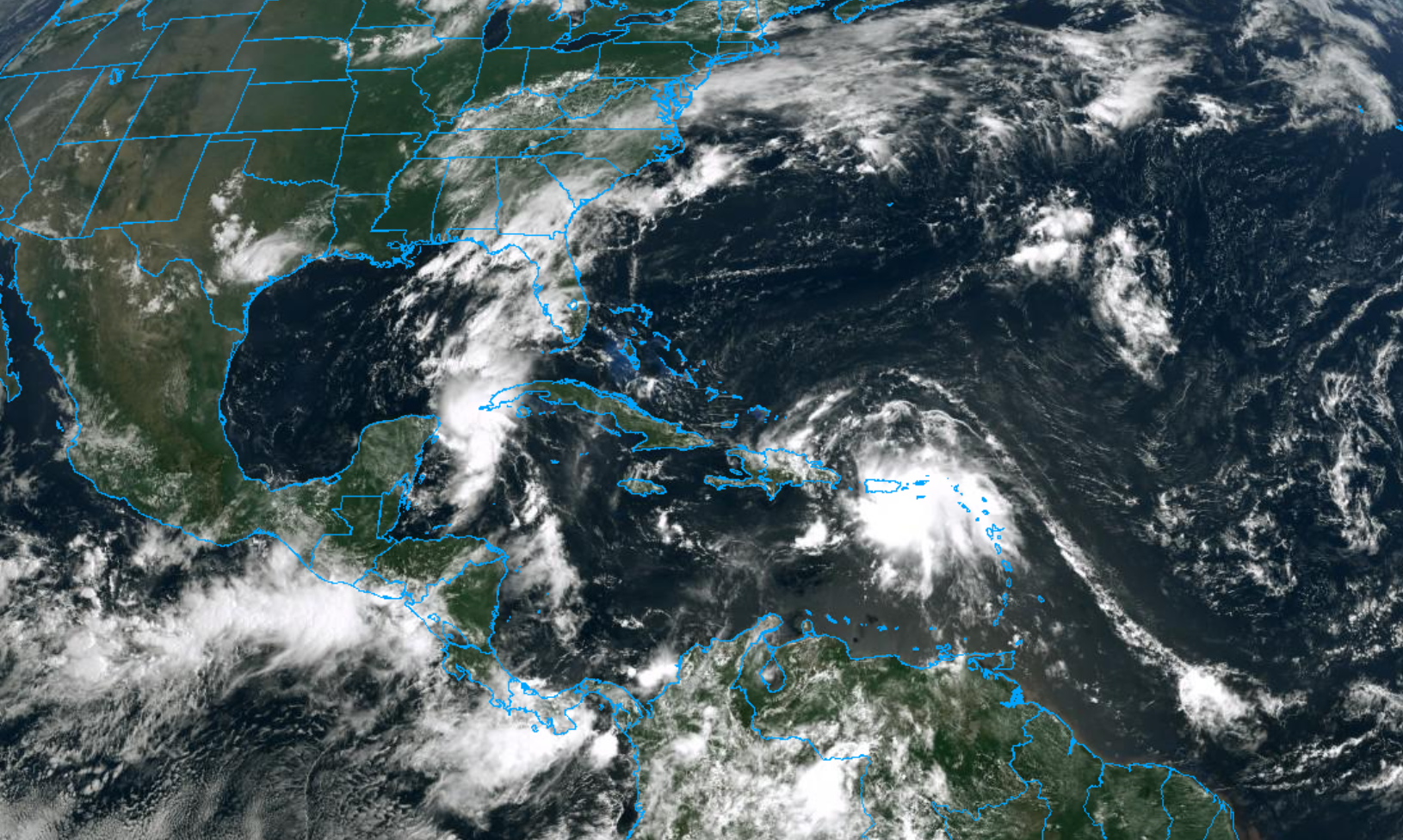
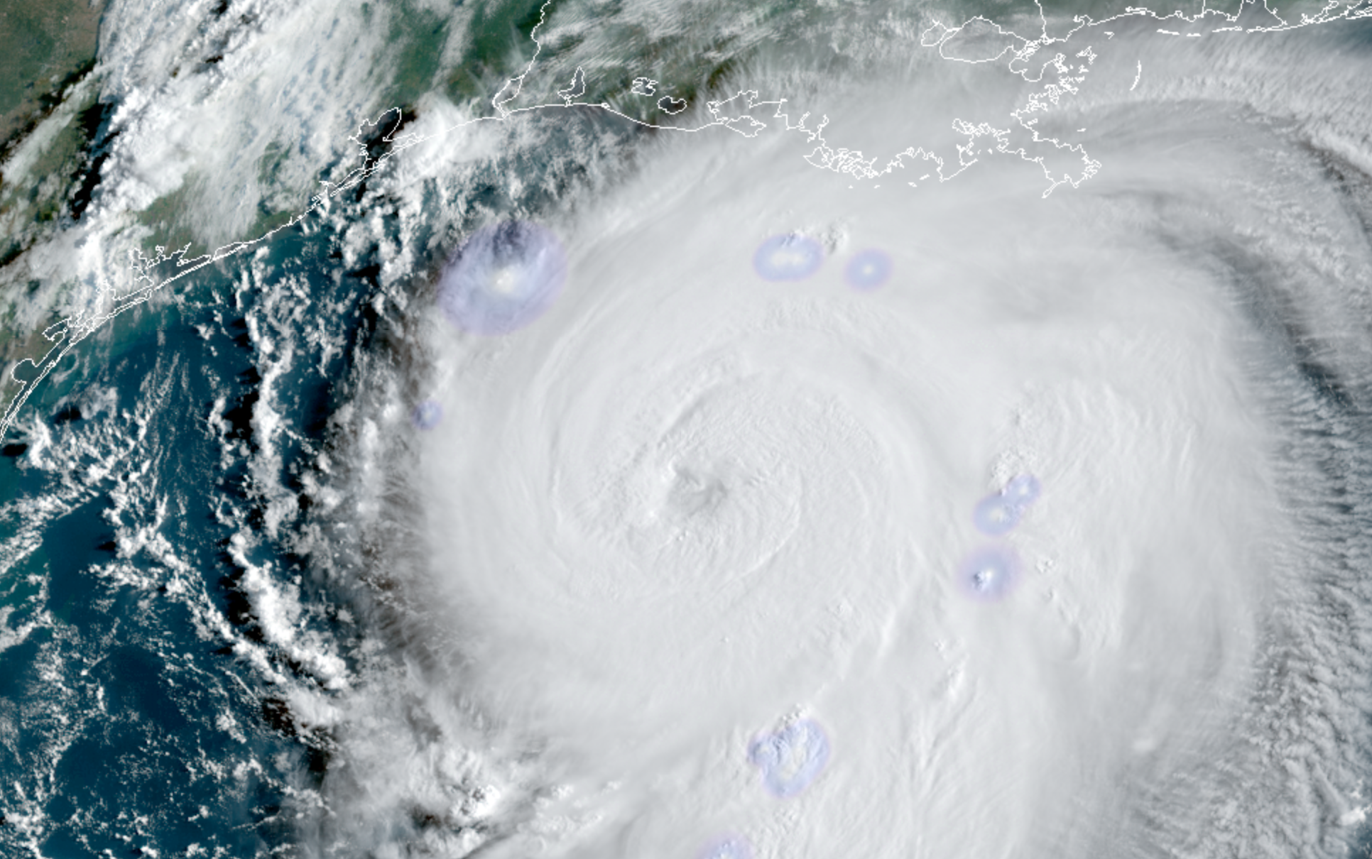
Hurricane Laura began rapidly strengthening last night, and has continued to do so this morning. Satellite data shows a powerful hurricane, with cold cloud tops marking intense convection and favorable outflow channels allowing the storm proper ventilation.

Airplane recon data collected from the most recent pass in the storm shows continued strengthening. Maximum sustained winds at both flight level and estimated at the surface have increased. The storms pressure is falling and cloud tops are warming as Laura tries to clear out an eye.

Secondary wind maxima slightly further away from the main eyewall suggested the possibility that the storm may eventually undergo an eyewall replacement cycle, but recent trends suggest that the wind field may simply just temporarily become larger. Concentric eyewall features have not yet been observed.

An eyewall replacement cycle occurs when convection develops outside the hurricanes eyewall and becomes more robust and organized – just enough so to remove some of the intensity of storms within the eyewall itself. The original eyewall then proceeds to collapse, and a new eyewall (usually a larger one) develops from the new thunderstorms.

Eyewall replacement cycles are relatively commonplace in strong hurricanes, but we don’t truly have a complete understanding of them yet. Sometimes, stronger hurricanes don’t undergo eyewall replacement cycles as frequently as we think they will – instead, stronger thunderstorms outside the eyewall simply merge into the original eye.

If an eyewall replacement cycle does take place with Laura over the next 12 hours or so, the structure of the storms core would slightly change. Intense winds within the eyewall would decrease ever so slightly (ex: from 130 to 120mph), but the radius of the strong wind field would expand. While eyewall replacement cycles often weaken the intensity of the most severe winds, they allow “still-severe” winds to expand outward from the storms center.

Eyewall replacement cycle breakdown (Zhang, Tau, 2016)

It remains to be seen if an eyewall replacement cycle will occur with Laura today. In reality, the storm may not have enough time to begin or complete one. But satellite trends and observations will be continually monitored as the storm continues to evolve through this evening.

More reading on eyewall replacement cycles is available here.

The forecast for Laura over the next several hours features continued strengthening. The National Hurricane Center expects the storm to reach Category 4 status before it makes landfall along the Texas or Louisiana coastline. There is some hope that strengthening southwesterly wind shear could at least disrupt the storm as it approaches the coast, but the storm is still expected to maintain wind speeds as high as 145 miles per hour as it reaches the coastline.

Significant threat to life and property as Laura makes landfall

Hurricane Laura is forecast by the National Hurricane Center to make landfall as a dangerous Category 4 hurricane. Maximum sustained winds over 135 miles per hour will be capable of producing widespread damage and destruction. In addition, catastrophic storm surge from 9 to 15 feet above ground is forecast along parts of the Texas and Louisiana coast – an additional threat to life and property.

From the National Hurricane Center: “Unsurvivable storm surge with large and destructive waves will cause catastrophic damage from Sea Rim State Park, TX to Intracoastal City, LA.”

As it stands this afternoon, the landfall location of Hurricane Laura appears likely to be somewhere between Port Arthur, TX and Lake Charles, LA.

Residents in the path of Laura are urged to follow the advice of local governments and heed evacuation warnings and requirements. If you are still in the area and live along the coast, it is too late to make hurricane preparations – now is the time to evacuate.

For the latest, we recommend heading to the National Hurricane Center website and reviewing their latest briefings.

Laura strengthening, will approach Texas coast as a major hurricane

Laura was upgraded to a hurricane this morning, per the National Hurricane Center, with maximum sustained winds of 75mph. The storm is tracking northwest into the warm waters of the Gulf of Mexico. It is expected to strengthen considerably over the next 24-36 hours and approach the Texas coastline as a major hurricane.

The forecast track of Laura has shifted slightly to the left over the past 24 hours. This puts the Galveston and Houston metro areas closer to storm, raising significant concern for impacts in those regions as the storm comes ashore.

Latest observations and trends

Laura is displaying signs of increased organization this morning, with convection wrapping around the center of the storm. Visible and infrared satellite imagery suggest ncreasingly coherent inner core. Northerly shear continues, but deep convection has begun to wrap around the storms center. Pressure is dropping and is expected to continue to fall through the afternoon.

The most recent recon missions into the storm suggest that the vortex may still be ever-so-slightly tilted as a result of northerly wind shear. Vortex tilting is not uncommon, especially for storms emerging from interactions with landmasses or undergoing wind shear. Nevertheless, it is when the low/mid level vortex’s become stacked that the system could begin to intensify rapidly. We will be carefully watching for that throughout the day.

Laura is in the process of moving over very warm waters in the Gulf of Mexico, in an environment characterized by low atmospheric wind shear. This should promote continued organization over the next 24-36 hours. The National Hurricane Center is forecasting rapid intensification, with the storm reaching Category 2 strength later on Wednesday.

In the short term, Laura has once again been tracking to the south/west of model forecasts. This is a trend that has been consistently observed over the past 24-48 hours. Northerly wind shear is likely causing downshear convective development and organization, readjusting the storms low level center, which model guidance is handling very poorly.

Microwave imagery over Laura showing the storms developing inner core.

In the next 12 hours or so, Laura will continue to traverse warm waters in a low shear environment. Organization should be steady to start, but may pick up in speed by tonight. The storm may cross a cooler eddy over parts of the Central Gulf tonight/tomorrow morning that may temporarily limit intensification, but it will then emerge back into warm waters shortly thereafter.

Major hurricane will target Texas coast

All global models and ensembles agree that Laura will target the Texas coastline as a major hurricane by the middle of this week. The forecast track has shifted slightly to the left over the past 24 hours, which puts areas like Galveston Bay and the Houston metro area in a precariously close position to the storms track.

Overnight EPS and GEFS ensembles both shifted slightly west, with a growing cluster of ensemble members tracking Laura close to Galveston Bay as a major hurricane. This trend has persisted for the past 24 hours – and is likely not unrelated to the short term trends of the storm verifying to the south/west of model positions.

Models have been trending west with Lauras track, bringing the storm closer to Houston and Galveston.

The main uncertainty with Laura’s track continues to relate back to its strength, and the steering of the storm as it moves over the Gulf of Mexico. Yesterday, we broke down the differences in model guidance as it relates to the systems strength. A stronger Laura, trending further southwest over time, is less susceptible to wind shear – and also is steered more westerly by the upper level/enfironmental winds.

A weaker Laura, drifting more northerly, would be steered more directly by the lower/mid level atmospheric winds – guiding the storm closer to the LA/TX border. This appears to be a more unlikely scenario at this time. As mentioned, Laura has repeatedly verified to the south and west of short term model solutions and is now showing signs of increased organization.

The westerly leaning models, which suggest Laura could strengthen and approach the TX coast as a major hurricane, should be weighted more heavily in the forecast moving forward, especially with more recent runs of the EPS and GEFS suite both leaning in that direction.

With that being said, our suggestion is to continue to follow the official National Hurricane Center forecasts when making decisions.

Life-threatening conditions possible as Laura approaches the coast

As Laura approaches the Texas coastline, the storm is expected to feature a myriad of life-threatening and potentially catastrophic hazards. These will include, but will not be limited to: Destructive winds, life-threatening storm surge, torrential rainfall, and tornadoes.

Residents along the entire Texas coastline are urged to make final hurricane preparations today as the storm system begins to develop in the Gulf of Mexico. Evacuation orders have already been issued for some areas like Galveston – and may be expanded later today.

There are a few important steps that you can take to help you and your family prepare:

  1. Develop a hurricane plan and discuss it with your family. Know where you will go, what you will bring, and how you will get there if and when the time comes that you need to move.
  2. Have a hurricane kit handy. This includes essential tools, non perishable foods, and supplies. 
  3. Know your flood zones in your local area. It is critically important to know which areas will flood first and how you should react.
  4. Know your evacuation routes. Research the routes and understand how you will need to get there if an evacuation is ordered. 
  5. Check official sources for weather information – most importantly, the National Hurricane Center and your local governments.

Our friends at Space City Weather are focused specifically on impacts to Houston. We strongly suggest following their blog posts for information if you live in the Houston area.

Laura expected to track into Gulf of Mexico, threaten TX/LA coast this week

Tropical Storm Laura continues its trek through the waters south of Cuba this morning. The storm has managed to avoid significant land interaction thus far, readjusting its center south of the shore. The National Hurricane Center says maximum sustained winds are 65 miles per hour. The system is expected to emerge into the Gulf of Mexico on Tuesday.

Read more

Tropical Storms Laura and Marco headed into Gulf, will threaten US next week

Atlantic tropical activity ramped up again this week, with Tropical Storm Laura forming east of the Northern Leeward Islands and Tropical Storm Marco forming in the Western Caribbean. Both systems are expected to enter the Gulf of Mexico in the coming days, and threaten the United States next week.

The uptick in Atlantic tropical activity was well forecast. A developing MJO wave and a CCKW propagating from the Pacific to the Atlantic gave meteorologists almost three weeks of warning. Now that tropical storms have developed, the uncertainty resides in where the systems will track and how they will behave as they do so.

Tropical Storm Laura

Tropical Storm Laura is currently 70 miles northwest of Port Au Prince, Haiti. It has maximum sustained winds at 50mph and is moving to the west-northwest at 21 mph. Tropical Storm Warnings are remain in effect for Cuba, Haiti, the Dominican Republic, the Southeast Bahamas and the Turks and Caicos Islands.

Laura has maintained it’s intensity so far, despite moving over Hispaniola. Favorable atmospheric condtions and orographic enhancement from the mountains of Hispaniola, has resulted in more intense-banding of convection just south and east of the low-level center. Laura’s track has shift slightly further south, closer to the southern coastlines of Haiti and Cuba. Thus Laura is more likely to maintain it’s intensity until it emerges into the Gulf of Mexico by Monday night or Tuesday.

Laura is currently forecast by NHC to track further south over the Hispaniola and Cuba coastline with little strengthening expected through Monday. It will then emerge over the Gulf of Mexico, where it could strengthen into a major hurricane before impacting the Texas and Louisiana coasts by Wednesday and Thursday.

There is some concern for rapid strengthening of Laura once it arrives in the Gulf of Mexico. If the storm does emerge into the Gulf of Mexico next week, the environment which it encounters could be characterized by very low shear and very warm waters – rocket fuel for tropical systems.

Interests along the Gulf of Mexico coastline should carefully watch the evolution of Laura in the coming days.

Tropical Storm Marco

Tropical Storm Marco is currently located in the South-Central Gulf of Mexico. It has maximum sustained winds at 70mph and is moving to the north-northwest at 12mph. Hurricane Warnings are now in effect for much of Southeast Louisiana. Marco is expected to become a minimal hurricane later today and impact Southeast Louisiana and Mississippi coasts on Monday.

As with Laura, there is uncertainty as to how Marco will behave once it enters the Gulf. The storm is generally expected to turn westward as a result of an upper level ridge, and may encounter more wind shear as a result. The official NHC forecast actually calls for the system to weaken back to tropical storm strength as a result. But when this happens is uncertain. Marco is small tropical cyclone, which can fluctuate in intensity quickly. Thus hurricane-force winds could still reach the coastline.

Uncertainty abound with both systems in Gulf

Both tropical systems are on a path towards the Gulf of Mexico over the next few days. This creates a tremendous amount of uncertainty, and forecast model guidance is struggling greatly to discern how each system will behave.

With both systems in the Gulf of Mexico, the tropical systems will almost certainly influence one another in some way. If they are close enough, it is possible that one tropical cyclone could grow stronger, negatively impacting the other – and vice versa.

ECMWF model showing both Laura (right) and Marco (left) in the Gulf of Mexico next week.

The strengthening or weakening of individual storms can also cause changes to the systems tracks and steering currents – commonly referred to as the Fuijiwhara effect, which is the binary interaction that can cause tropical systems to circle around each other or even merge. However, with Marco now expected to make landfall on Monday and Laura tracking further south and west over the Gulf of Mexico, chances of this interaction occurring have decreased.

There is a lot to consider with these possible interactions, and its worth noting that the tracks of the systems could change dramatically from the current forecast. If you live along the Gulf Coast of the United States, now is the time to prepare in advance. Do not focus on the exact forecast tracks of the systems at this time. Instead, make preparations in advance for a tropical system and adjust accordingly as the event draws closer.