NOAA released their 2022 Hurricane Season Forecast today, calling for an above-average season in terms of tropical activity in the Atlantic Ocean. The forecast for a more active season was largely expected based on the continuation of weak La Niña conditions as well as the sea surface temperature configuration across the hemisphere this Spring.
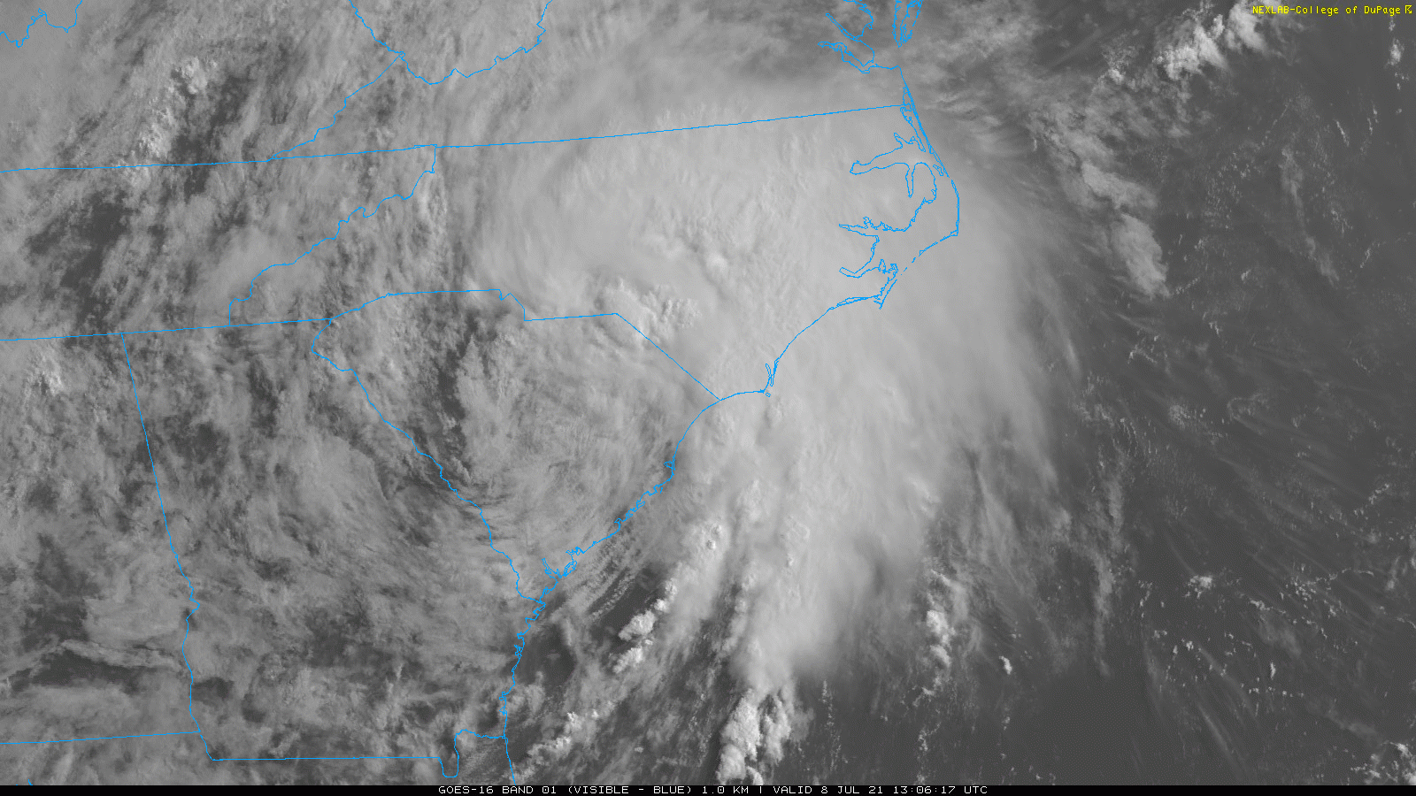
A frontal boundary and upper-level trough northwest of the area will begin to interact with Tropical Storm Elsa tracking northeast up the coast today. Scattered showers and thunderstorms will begin to develop around the region this afternoon and early this evening, with a muggy, unstable airmass in place. These storms could become strong or severe and capable of producing isolated damaging wind gusts or tornadoes, especially with stronger shear and forcing over the Interior areas.
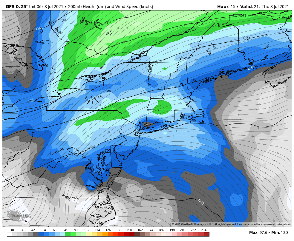
Then the right-rear quadrant of an upper-level jet streak will begin to move closer and enhance forcing over more of the region. This will cause more widespread showers and thunderstorms to develop ahead of Tropical Storm Elsa later this evening. This process is also known as a Predecessor Rain Event, which occurs well in advance of a tropical system reaching the area. These showers and thunderstorms this afternoon through early tonight could contain torrential downpours and result in localized flash flooding.
The GFS model shows the Northeast US right -rear quadrant of the upper-level jet, which will enhance rainfall ahead of Elsa
Tropical Storm Elsa is currently a minimal tropical storm with maximum sustained winds at 45 mph and is moving northeast at 20mph. Elsa could intensify more as a tropical storm tonight and tomorrow as it begins to phase with the upper-level jet streak. The exact track of Elsa will determine the amount of the impacts on the area. Tropical systems undergo baroclinic enhancement (phasing) the Mid-Atlantic and Northeast US, have the heaviest rains on the west side of the track and strongest winds on the east side.
The National Hurricane Center forecast and watches and warnings for Elsa
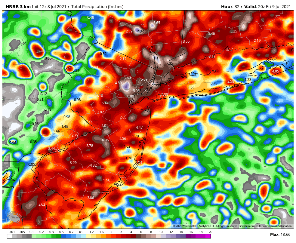
Based on the latest forecast track from the National Hurricane Center, which takes Elsa over Southeast New Jersey and Eastern Long Island, heavy rainfall and flash flooding will biggest threat for New York City metro and inland areas of New Jersey and Connecticut. A period of steadier, heavier rain with some gusty winds is likely very late tonight or Friday morning. Widespread rainfall totals between 2 to 4 inches and locally higher totals are likely by Friday afternoon. Flash flooding could occur on roadways and make for hazardous driving conditions. Never drive through flood waters!
The strongest winds from Elsa are most likely to occur late tonight and Friday morning over Long Island and coastal sections of New Jersey and Connecticut, where the Tropical Storm Warnings have been issued. Sustained winds could be between 40-50mph with gusts up to near 60mph for at least a few hours, as Elsa’s center passes nearby. These winds could cause tree damage and power outages. Around New York City, winds are likely to be between 20-30mph with some gusts to up to near 40mph possible.
The HRRR models shows rainfall totals widespread 2″-4″ and locally up 6″ in the region
Tropical Storm Elsa will be tracking quickly through the region. So we don’t anticipate any significant storm surge or coastal flooding in the region. There is also a low risk for Elsa’s outer rain bands to produce a few isolated tornadoes or waterspouts, especially along coastal sections later tonight into Friday morning.
We will continue to monitor the latest developments with Elsa’s remnants until they depart the area quickly late Friday morning. Some scattered showers and thunderstorms may redevelop in the area Friday afternoon and evening with frontal boundary still nearby.
Overall, we aren’t expecting severe impacts from Elsa. But any changes in the current forecast track could result in heavier rains impacting coastal sections more or stronger winds further inland. Check back this briefing or on our social media accounts for more updates.
https://www.nymetroweather.com/wp-content/uploads/2021/07/Elsa-Visible-Image.gif9001600Miguel Pierrehttps://www.nymetroweather.com/wp-content/uploads/2024/02/Empire-2000-x-300-px-2.pngMiguel Pierre2021-07-08 11:17:172021-07-08 11:35:46Tropical Storm Elsa Impacts for the NYC Metro Area
There is truly no rest for the weary when it comes to tropical activity in 2020. The hurricane season which was forecast to be hyperactive has been, well, hyperactive. The National Hurricane Center named three more storms today: Wilfred, Alpha and Beta. This is the first time in history that three storms have been named within a 24-hour span.
https://www.nymetroweather.com/wp-content/uploads/2020/09/Screen-Shot-2020-09-18-at-3.02.10-PM.png12422196John Homenukhttps://www.nymetroweather.com/wp-content/uploads/2024/02/Empire-2000-x-300-px-2.pngJohn Homenuk2020-09-18 16:56:232020-09-18 16:56:30Tropics: More records fall as Wilfred, Alpha and Beta form on same day
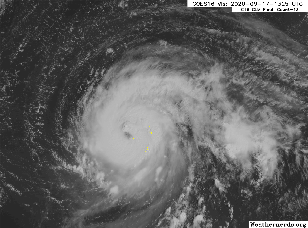
Hurricane Teddy continues churning in the Atlantic this morning, with maximum sustained winds of 105mph. The storm has strengthened, and recent satellite imagery shows continued bursts of impressive convection near the storms center. The National Hurricane Center forecasts Teddy to strengthen to a major hurricane later today.
https://www.nymetroweather.com/wp-content/uploads/2020/09/16422867-2-1.gif7801050John Homenukhttps://www.nymetroweather.com/wp-content/uploads/2024/02/Empire-2000-x-300-px-2.pngJohn Homenuk2020-09-16 21:25:142020-09-17 11:13:47Hurricane Teddy could prove to be a major forecasting challenge
Hi friends! Our website uses cookies to provide an optimal browsing experience for you. New "Cookie Consent" laws mandate us to inform you of this. As long as you're cool with it, just hit OK. You'll only see this message once.
We may request cookies to be set on your device. We use cookies to let us know when you visit our websites, how you interact with us, to enrich your user experience, and to customize your relationship with our website.
Click on the different category headings to find out more. You can also change some of your preferences. Note that blocking some types of cookies may impact your experience on our websites and the services we are able to offer.
Essential Website Cookies
These cookies are strictly necessary to provide you with services available through our website and to use some of its features.
Because these cookies are strictly necessary to deliver the website, refusing them will have impact how our site functions. You always can block or delete cookies by changing your browser settings and force blocking all cookies on this website. But this will always prompt you to accept/refuse cookies when revisiting our site.
We fully respect if you want to refuse cookies but to avoid asking you again and again kindly allow us to store a cookie for that. You are free to opt out any time or opt in for other cookies to get a better experience. If you refuse cookies we will remove all set cookies in our domain.
We provide you with a list of stored cookies on your computer in our domain so you can check what we stored. Due to security reasons we are not able to show or modify cookies from other domains. You can check these in your browser security settings.
Other external services
We also use different external services like Google Webfonts, Google Maps, and external Video providers. Since these providers may collect personal data like your IP address we allow you to block them here. Please be aware that this might heavily reduce the functionality and appearance of our site. Changes will take effect once you reload the page.
-2")