Posts

Increasing clouds, tropical rains late week

[alert type=”error”]Hazardous Weather Briefing for T.S Andrea is now available. [/alert]

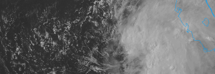
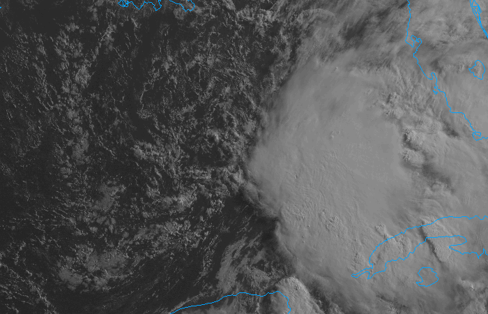
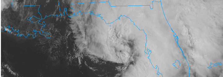
Tropical Storm Andrea formed last night in the Eastern Gulf of Mexico, and has strengthened into a system with maximum sustained winds of 60 miles per hour. Andrea is forecast to head northward, making landfall on the Florida Gulf Coast later today. More importantly for our area, she will then scoot north and east to a point off the Mid-Atlantic Coast late Friday Night into early Saturday morning. As she is absorbed into a mid level trough which will be scooting across the Ohio Valley, the surface low pressure associated with Andrea will likely feature the potential for heavy tropical rains on the west side of it.

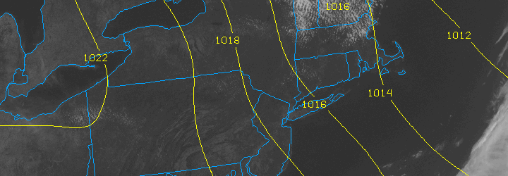
After a good start to Thursday, we are expecting the potential for rain to increase — with mid and high clouds building into the area. Friday and Saturday could both feature periods of heavy tropical rains, with plenty of moisture and humidity and the potential for some thunderstorms as well.

Thursday: Partly cloudy early, becoming mostly cloudy late. Highs in the lower 70’s. Southeast wind around 10 miles per hour. E njoy the sun while you can!

Thursday Night: Cloudy with rain likely, becoming heavy at times late. Lows near 60. East wind around 10 to 15 miles per hour. Bring a rain coat, but you won’t be too chilly — the humidity will increase.

Friday: Heavy rain likely, with a high near 71. East winds around 10 miles per hour. A washout of a day for sure . Bring an umbrella and a rain coat — it will be a soaker.

Read more

PM Update: Pleasant evening, clouds on the increase

A gorgeous Wednesday is wrapping up throughout the NYC Area with temperatures in the middle 70’s and light southerly winds — a true gem of a day which featured low humidity and enjoyable conditions for early June. The pleasant weather is on the way out by later this week, however, with clouds increasing on Thursday and chances for rain increasing as well. Periods of steady rain are possible with tropical moisture surging into the area this weekend.

Rest of Tonight: Pleasant evening, with temperatures in the middle 70’s, falling into the upper 50’s. A bit cooler, as usual, near the shore and in the suburbs. Clouds could increase by later in the overnight period towards early morning.

Thursday: Partly to mostly cloudy in the morning with some breaks in the clouds during the afternoon. The showers should hold off until late — so it appears that Thursday could be salvaged. Highs in the lower 70’s throughout the area with a southeast breeze. It will be a little cooler near the shore.

Tropical Storm Andrea forms, remnants likely to impact the area: NWS Recon planes found Tropical Storm force winds and a closed center in a tropical entity in the Gulf of Mexico this evening — and will begin issuing advisories on Tropical Storm Andrea tonight. More importantly for our area, the tropical system will be scooped up by a progressive trough over the Ohio Valley late this week.

Forecast models are in good agreement on the fact that a surface low will eventually make its way up the east coast — with periods of heavy rain likely near and to the west of the surface low. The exact track of the surface low remains somewhat uncertain, and will determine where the heaviest rain falls. Regardless, it looks like a cloudy and rainy forecast from Thursday Night through Saturday.

Cicadas peaking in the suburbs: Just three weeks after they first appeared, the 17 year Brood II Magiciadas are causing a dramatic ruckus in the suburbs of NYC including New Jersey, Southeast NY and Connecticut. Many areas in Northeast NJ (specifically Union. Morris and Essex counties) have reported millions per square mile. The sound of the cicadas mating call is one of the loudest sounds in nature.

The cicadas will make a ton of noise over the next few days — but after mating will begin to die off as quickly as they came. After the females lay eggs in the branches, the cicadas will die off completely. The nymphs will hatch from the branches later this summer, and drop to the ground. Soon after they will bury underground, and won’t be seen again for another 17 years.

GOES 13 will return tomorrow: The “broken” weather satellite GOES-13 is expected to return to service on June 6th, 2013. The satellite has been out of service since May 22nd, 2013 after suffering from an unknown disturbance. Our friends at Climate Central have all the details.


Tropical moisture could spoil weekend

The pleasant, dry and less humid weather which has settled into the area during the middle of this week, however enjoyable, looks to be short lived. Forecast models have been consistent in taking a weak (possibly tropical) system with an impressive amount of low level moisture, and tracking it from the Gulf of Mexico up along the East Coast. With the weak shortwave being scooped up by a progressive trough over the Ohio Valley, a surface low is forecast to develop and move up the East Coast beginning Thursday and continuing into early Saturday.

The system in the Gulf of Mexico, which is forecast to develop into a tropical entity by some models, is struggling amidst strong upper level winds. But it still may develop into a weak system before ejecting north and east and being absorbed into the mid level flow. The National Hurricane Center suggests the system has a 50% chance of developing into a tropical system.

Visible satellite imagery of a tropical disturbance in the Gulf of Mexico on the morning of June 5th, 2013.

Visible satellite imagery of a tropical disturbance in the Gulf of Mexico on the morning of June 5th, 2013.

The result, in terms of sensible weather for our area, will be clouds and showers beginning late Thursday and continuing through at least the first part of the weekend. The exact track of the surface low and interactions aloft will determine where the heaviest rain falls, but needless to say periods of rain are likely with the potential for some thunderstorms as well. Late Thursday into early Saturday in particular look to feature the most unsettled weather. Things look to clear out a bit during the day on Saturday, so Sunday could be salvaged if the timing holds up.

Be sure to follow our social media accounts on both Facebook and Twitter for up to the minute information and interaction.

Cooler, pleasant weather behind cold front

The warm and humid airmass from this past weekend is a distant memory this afternoon, as cooler air with lower dew points has settled into the area. A refreshing northwest breeze will continue for the remainder of the day with high temperatures around average in the mid 70’s. The trend is expected to continue through the middle of the week, with more sun and slightly warmer temperatures on Wednesday — but not hot or humid at all.

Not all of the news is good, however. The forecast takes a bit of an unsettled turn by late Thursday and Friday and may become quite ugly by the weekend as a tropical moisture feed extends up the East Coast of the United States. Forecast models are showing a trough sinking through the Ohio Valley and Northeast by the weekend, with showers becoming likely with periods of heavy rain also a possibility if a weak surface low pressure system can form offshore.

We’ll keep a close eye on it as the week goes on, but for now enjoy the beautiful weather! Remember to check our social media accounts for frequent updates.