Posts

PM Update: Scattered storms, unsettled Monday

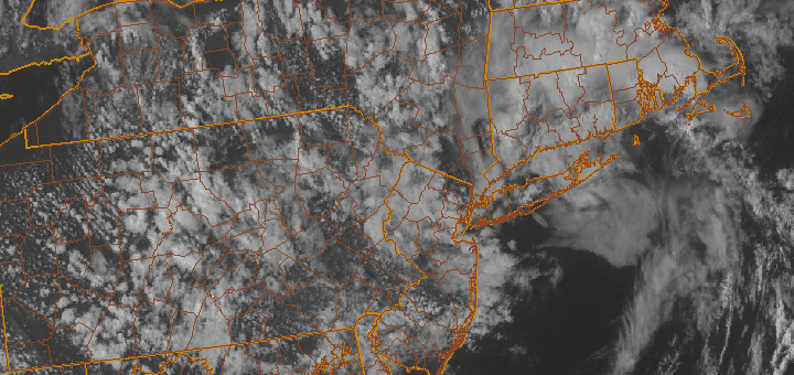
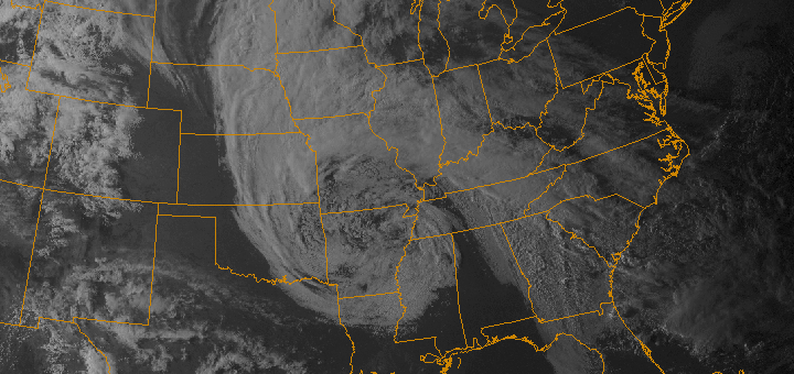
After a weekend of heat (temperatures over 90 degrees since last Thursday in many locations), scattered showers and thunderstorms have developed this evening throughout the area. The main organized severe weather threat remained to our north, over New England, where better shear allowed for more widespread organized severe thunderstorms. Despite plenty of sun and instability in our area, storms have had trouble developing and becoming organized. Forecast models, however, are insistent that storms — and areas of steady rain — will develop from Sunday evening through Monday as the front slows near the area.

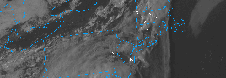
The unsettled weather, with showers and clouds, is expected to continue into Monday as the warm and humid airmass gets washed away. The news is not all bad, however — after the front passes Monday evening, a seasonal airmass will move into the area. This will bring with it the return of highs in the mid 70’s and lower humidity with pleasant weather in the forecast through the upcoming work week.

Things will gradually warm up again by the end of the week, with warm air advection bringing a chance of some showers into the forecast as well. Stay tuned for more updates and details as the week moves along. Have a great Sunday evening!

PM Update: Warm, stormy end to the work week

Unsettled weather has gripped the area over the past day or so — after a prolonged period of pleasant and dry weather. Over 2 inches of rain fell in New York City on Wednesday as an upper level low moved near the area and moisture streamed into the area. Thursday featured some rain as well, but it was more spotty and scattered as opposed to the synoptic type heavy rain which fell along the warm front Wednesday. The forecast will remain unsettled through the end of the work week and into the weekend, but a warming trend will also be noticeable. This will be especially true on Friday, ahead of a cold front, when temperatures could warm into the upper 70’s to lower 80’s throughout much of New Jersey towards New York City.

The catch, however, will be the disturbance approaching aloft — and the cold front approaching at the surface. Showers and thunderstorms will become scattered by Friday afternoon over Pennsylvania and Western New Jersey and could move into the area overnight Friday into Saturday. Although Saturday will likely be warm as well, thunderstorms and periods of rain appear likely with the frontal boundary near the area. The Storm Prediction Center has placed the area in a 5% risk of severe thunderstorms (a tier below the 15% that would trigger a “Slight Risk). Clearing is expected by Sunday with colder temperatures moving into the area behind the front.

Stay tuned over the next day or so for updates on the approaching disturbance and cold front, as well as any potential thunderstorms and associated watches and warnings.

For a day-by-day breakdown of the forecast, check out our Forecast Brief. If you’re looking to get more details and technical reasoning, check out our Technical Forecast Discussion. Have a great night!

Pleasant pattern will come to an end next week

[alert type=”info”]Don’t Forget! The Eta Aquarid meteor shower peaks Saturday Night through Sunday Morning. Good viewing conditions are expected with clear skies. Up to 30 meteors per hour possible. Let us know if you see any![/alert]

Blocking patterns often produce anomalous weather somewhere in the United States — and frequently, it occurs in the Eastern 1/3 of the United States. Not this time. The blocking pattern, which became anomalous late this past week, drove a cutoff low into the Central United States that produced an amazing late-season snowfall across parts of the United States. The unsettled weather, however, has remained over the Central United States thus far and has not made much progress to the east — as the block has actually collapsed overhead and high pressure in association with it has settled over the Northeast US.

This will change next week. Until then, however, a few more days of pleasant weather can be expected through the weekend and into early next week. The game changer will occur once the decaying cutoff low, once responsible for historic late season snow over the Central US, drifts up the Eastern seaboard. Forecast models are in good agreement that it will bring increased chances of showers and thunderstorms as well as cooler temperatures. In addition, a slightly cooler and more unsettled pattern looks likely through the medium to long term forecast period.

For a day-by-day breakdown of the forecast, check out our Forecast Brief. If you’re looking to get more details and technical reasoning, check out our Technical Forecast Discussion. Have a great Saturday night!

Despite deary start, sun returns by midweek

[alert type=”success”]Special: Check out our daily video forecast. If you wish to view a video forecast each day, register with us and head to the “Video” page under the Members tab. Enjoy![/alert]

Dreary conditions, which took control of the areas weather on Monday into early Tuesday, will give way to the return to sun and seasonable temperatures by later on Tuesday. After a cloudy and potentially drizzly start to the day, high pressure to the north and east will begin to strengthen and nudge towards the area as an atmospheric disturbance aloft weakens. As this occurs, clearing is expected to push into the area from the east. Areas that see the sun on Tuesday will be able to warm up into the 60’s despite a light east/southeasterly wind.

Read more