High pressure with mid-level ridging builds into the region today. This will support more sunshine, with just some high cirrus passing through at times. After a cold start this morning, temperatures will rise into upper 30s to lower 40s this afternoon. Northwest winds will lighter to today, as a deep low moves further out into the Atlantic. So won’t feel as cold this afternoon, as Thursday afternoon was.
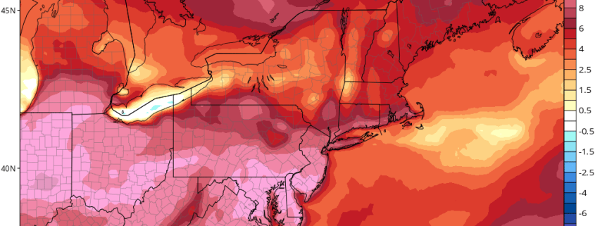
https://www.nymetroweather.com/wp-content/uploads/2017/02/namconus_T2ma_neus_10.png7721024Miguel Pierrehttps://www.nymetroweather.com/wp-content/uploads/2024/02/Empire-2000-x-300-px-2.pngMiguel Pierre2017-02-17 10:31:242017-02-17 10:38:352/17 Late AM All Zones Update: Unseasonably Mild Weather This Weekend
Cooler and unsettled has arrived late this week, as anticipated. This morning showers are moving northward with moderate to heavy downpours, over Eastern NJ, NYC metro and into Lower Hudson Valley. These showers will move north of region by early this afternoon. But more showers could developing later this afternoon and evening as a cold front and a wave of low pressure developing along it approaches the region. Some locally moderate to heavy downpours with possible with any showers. But some subsidence between the cold front and another system offshore, will likely keep showers from becoming more widespread over region and could cause clouds to break for more sunshine this afternoon. This will help temperatures rise into the lower to mid 70s this afternoon, over much of the region.
After some areas of morning patchy fog. Today turned out beautiful day with temperatures rising in the middle 70s this afternoon. Skies will remain mostly clear this evening, then clouds will increase again later tonight, as low-moisture increasing underneath an inversion. Some areas of patchy fog and drizzle could also be around again early tomorrow morning. Low temperatures tonight will drop into the 50s over most region. Closer to 60 for NYC metro and urban areas.
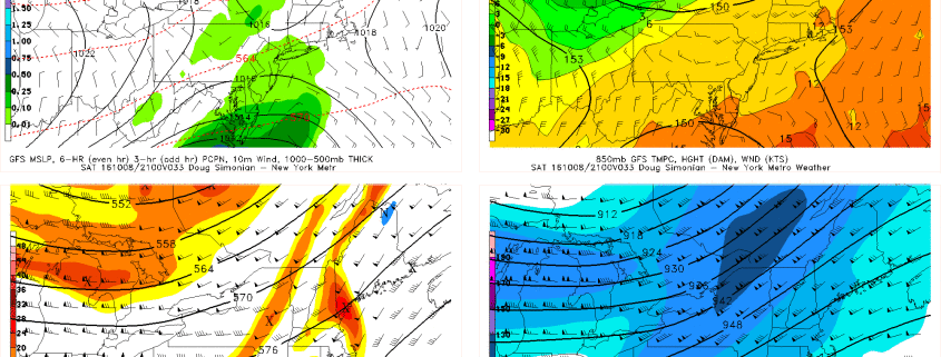
https://www.nymetroweather.com/wp-content/uploads/2016/10/MSLP850500300gfs12033.gif13502000Miguel Pierrehttps://www.nymetroweather.com/wp-content/uploads/2024/02/Empire-2000-x-300-px-2.pngMiguel Pierre2016-10-07 16:00:422016-10-09 05:47:21Weekend Overview: Showers Possible Saturday, Matthew Parallels the Southeast Coast
Beautiful, summery weather is store for this weekend with high pressure north and east of region in control. Today will have plenty of sunshine with temperatures rising into upper 80s around 90 this afternoon, especially inland. Light easterly winds may keep some areas near the shore a little cooler in the lower to middle 80s. These temperatures, are still several degrees warmer than average for this time year. But humidity will be more comfortable. Skies will remain mostly clear tonight with temperatures dropping into lower 70s over NYC metro and down into 60s in suburbs overnight.
Sunday will be mostly sunny again with high temperatures likely in middle to upper 80s, at least over inland sections. However, with high pressure further shifting northeast of the region, this will cause more southeast winds and sea-breezes to develop during the afternoon, especially over parts of Long Island and other south-facing shore. Which may see high temperatures only in the lower to middle 80s tomorrow. Which is still slightly above average. Some other highlights for the next few days:
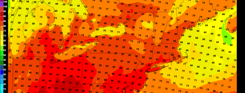
https://www.nymetroweather.com/wp-content/uploads/2016/08/2mtempgrid0612.png11751850Miguel Pierrehttps://www.nymetroweather.com/wp-content/uploads/2024/02/Empire-2000-x-300-px-2.pngMiguel Pierre2016-08-27 08:40:032016-08-27 08:40:03Weekend Overview: Very Warm and Dry Weather Through Sunday
Hi friends! Our website uses cookies to provide an optimal browsing experience for you. New "Cookie Consent" laws mandate us to inform you of this. As long as you're cool with it, just hit OK. You'll only see this message once.
We may request cookies to be set on your device. We use cookies to let us know when you visit our websites, how you interact with us, to enrich your user experience, and to customize your relationship with our website.
Click on the different category headings to find out more. You can also change some of your preferences. Note that blocking some types of cookies may impact your experience on our websites and the services we are able to offer.
Essential Website Cookies
These cookies are strictly necessary to provide you with services available through our website and to use some of its features.
Because these cookies are strictly necessary to deliver the website, refusing them will have impact how our site functions. You always can block or delete cookies by changing your browser settings and force blocking all cookies on this website. But this will always prompt you to accept/refuse cookies when revisiting our site.
We fully respect if you want to refuse cookies but to avoid asking you again and again kindly allow us to store a cookie for that. You are free to opt out any time or opt in for other cookies to get a better experience. If you refuse cookies we will remove all set cookies in our domain.
We provide you with a list of stored cookies on your computer in our domain so you can check what we stored. Due to security reasons we are not able to show or modify cookies from other domains. You can check these in your browser security settings.
Other external services
We also use different external services like Google Webfonts, Google Maps, and external Video providers. Since these providers may collect personal data like your IP address we allow you to block them here. Please be aware that this might heavily reduce the functionality and appearance of our site. Changes will take effect once you reload the page.
-2")