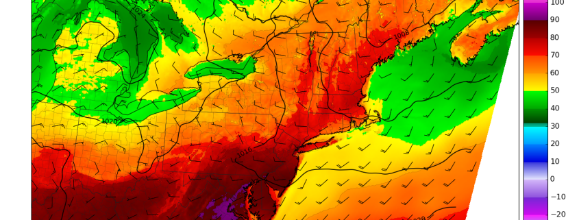
Happy Friday! Much warmer weather has returned today and will stick around until Saturday. Then a backdoor cold front will move through region, with a cooler temperatures returning again on Sunday. Another cold front moves through the region with more showers and thunderstorms possible late Monday and into early Tuesday of next week. Get details in latest forecast breakdown below!
https://www.nymetroweather.com/wp-content/uploads/2017/04/12zNAMtemperatures.png8101260Miguel Pierrehttps://www.nymetroweather.com/wp-content/uploads/2024/02/Empire-2000-x-300-px-2.pngMiguel Pierre2017-04-28 13:26:022017-04-28 13:26:02Midday Zones Update: More Warmth Saturday, Cooler Sunday, More Unsettled Early Next Week
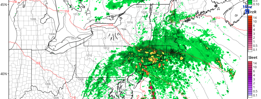
A cut-off low that we have been discussing here since last week, will finally bring some heavy rainfall to much of the region, this afternoon and early evening. Afterward, some unsettled weather will continue over the couple of days, as the cut-off low weakens and slowly moves away from the region. Then more pleasant weather with much warmer than normal temperatures return for the end of the week and start of the weekend. But a backdoor cold front may spoil the warm up later in the weekend! Get more details on the weather over next several days in a breakdown below.
https://www.nymetroweather.com/wp-content/uploads/2017/04/nam3km_mslp_pcpn_frzn_neus_16.png7721024Miguel Pierrehttps://www.nymetroweather.com/wp-content/uploads/2024/02/Empire-2000-x-300-px-2.pngMiguel Pierre2017-04-25 08:08:002017-04-25 08:08:00AM All Zones Update: Cut-off Low with Heavy Rain Today, Warmer Late Week
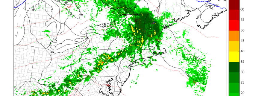
Happy Thursday! After some showers around the region earlier this morning, some unsettled weather continues. Some clouds will still be around for rest of the day, with frontal boundary over the region. But some dry-air with a northwest flow developing aloft will allow for more breaks of sunshine this afternoon.. This will help temperatures rise further into the mid-upper 60s to lower 70s much of the region by late this afternoon. Onshore winds and more low clouds will still keep some coastal areas from rising out of the mid-upper 50s.
https://www.nymetroweather.com/wp-content/uploads/2017/04/3kmNAMradar-1.png8101260Miguel Pierrehttps://www.nymetroweather.com/wp-content/uploads/2024/02/Empire-2000-x-300-px-2.pngMiguel Pierre2017-04-20 13:41:042017-04-20 13:41:04Midday All Zones Update: Some Unsettled Weather Continues
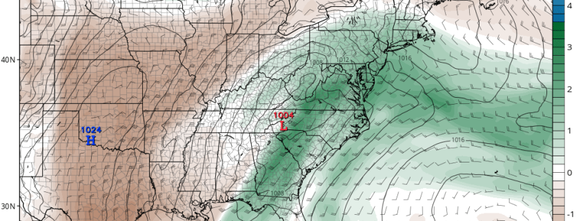
Good evening! We had a lovely Spring day with sunny skies and temperatures in the 60s, but winds are picking up a bit along the coast as winds turn more onshore and a marine layer develops. For more on these short term changes including the chance for light rain on Wednesday night into Thursday, please be sure to check the dashboard and read our latest zone article updates! This article will be focused on the two upcoming disturbances: one for Thursday night into Friday, and another one for Sunday into Monday. Both could bring periods of heavy rain, but uncertainty is still high as it’s also still possible that little rain falls from either system.
After the periods of light rain on late Wednesday night into Thursday, a stronger storm system will be traversing the Great Lakes. This will allow a warm front to surge northward towards the area, which may place us in the warm sector. There is still uncertainty with how far north this warm front gets — they often can get a bit hung up this time of year and not progress as far northward as model guidance indicates. This is important because if the warm front stays further south, we may not enter the warm sector and thus may remain too stable for heavy showers and thunderstorms.
https://www.nymetroweather.com/wp-content/uploads/2017/04/12.png7861024Doug Simonianhttps://www.nymetroweather.com/wp-content/uploads/2024/02/Empire-2000-x-300-px-2.pngDoug Simonian2017-04-18 20:50:042017-04-19 06:43:41Analysis: Two Disturbances to Watch
Hi friends! Our website uses cookies to provide an optimal browsing experience for you. New "Cookie Consent" laws mandate us to inform you of this. As long as you're cool with it, just hit OK. You'll only see this message once.
We may request cookies to be set on your device. We use cookies to let us know when you visit our websites, how you interact with us, to enrich your user experience, and to customize your relationship with our website.
Click on the different category headings to find out more. You can also change some of your preferences. Note that blocking some types of cookies may impact your experience on our websites and the services we are able to offer.
Essential Website Cookies
These cookies are strictly necessary to provide you with services available through our website and to use some of its features.
Because these cookies are strictly necessary to deliver the website, refusing them will have impact how our site functions. You always can block or delete cookies by changing your browser settings and force blocking all cookies on this website. But this will always prompt you to accept/refuse cookies when revisiting our site.
We fully respect if you want to refuse cookies but to avoid asking you again and again kindly allow us to store a cookie for that. You are free to opt out any time or opt in for other cookies to get a better experience. If you refuse cookies we will remove all set cookies in our domain.
We provide you with a list of stored cookies on your computer in our domain so you can check what we stored. Due to security reasons we are not able to show or modify cookies from other domains. You can check these in your browser security settings.
Other external services
We also use different external services like Google Webfonts, Google Maps, and external Video providers. Since these providers may collect personal data like your IP address we allow you to block them here. Please be aware that this might heavily reduce the functionality and appearance of our site. Changes will take effect once you reload the page.
-2")