Posts

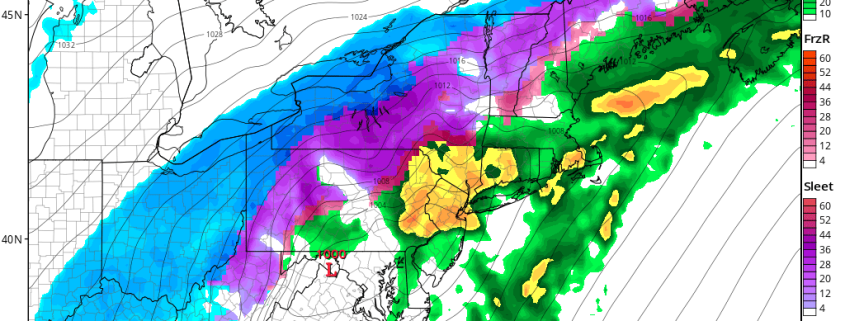
Friday Briefing: Warmer times East, winter storm looms in Plains

Good morning and Happy Friday! We’re excited to introduce our daily briefing posts. Think of these as your “go-to” posts for weather information in the morning, whether you’re sipping a coffee or sitting on the train. Or both. We’ll lay out the important weather information with links and details on what’s ahead. More technical posts will follow throughout the day – but these will be the first checkpoint to see what’s going on.

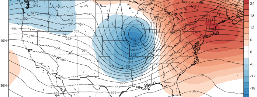
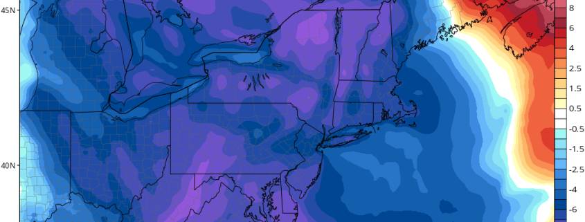
So here we are! It has been a long and hard stretch of cold weather in the Northeast States. In fact, January is running well below normal in terms of temperature essentially from the Great Plains to the Northeast US Coast. That’s all about to change – big time changes in the Pacific Ocean will lead to changes in how the atmosphere is behaving across the United States. The storm track will shift west, and a ridge will build over the East. The result? Warmer temperatures for the East Coast and a pattern that will become inherently less wintry.

Read more

More Volatile Pattern with Significant Storm Threats Into Next Week

Happy Wednesday! High pressure will be off the Northern-Mid-Atlantic coast with more light onshore winds today. Sunshine this morning will be fading behind more high clouds this afternoon, as mid-level warm air advection increases. Temperatures are expected to be a little cooler this afternoon with highs in the upper 30s to lower 40s. These temperatures closer to normal for this of time year.

Mostly cloudy skies are expected for tonight and Thursday, as mid-level warm-air advection increases, ahead of approaching warm front. Temperatures will actually hold steady this evening the slow rise into into the mid-upper 40s by Thursday morning. Highs on Thursday afternoon will be in the upper 40s to lower 50s. On top of the remaining snow pack, moisture levels or dewpoints will be increasing underneath inversion, leading to some areas of patchy fog and drizzle.

Read more

Wintry Mix for Interior Northeast Tuesday Before Arctic Blast Arrives, Late Week Storm Threat?

Good evening! Chilly and dry weather will continue for rest of the evening hours. But clouds will thicken and increase overnight, as the next storm system approaches. Mid-level warm advection ahead of warm front will start to cause Some light precipitation to break out well after midnight. Temperatures in the lower and mid-levels will be warmer, especially over New York City and coastal areas. So mainly rain is expected, although some snowflakes and ice pellets at the onset, can still occur. Otherwise, mainly some rain showers are expected through tomorrow morning, as temperatures rise into mid-upper 40s.

Over the Interior, especially higher elevations of Northwest New Jersey, the Hudson Valley and Northern CT more light snow, sleet and freezing rain is possible. This could leave coating to an 1″ or 2”, before perhaps change to rain during the midday hours. Temperatures will like rise only into the upper 30s to lower 40s in these areas during the afternoon. But should lead some snow and ice melting on on roadways and other paved surfaces. All precipitation will taper off during the early afternoon hours, as best dynamics begin to move northward into Northern New England.

Read more

ENSO Update: Weak La Nina Likely for the Winter

Good afternoon! We continue to monitor developments with La Nina this weekend, as it will one important features will be considering in our monthly and winter forecasts. Sea-surface temperatures this past week, have cooled over more of ENSO regions in the Central and Eastern Pacific, as anticipated in our last major update. The thermocline (sea-surface temperature gradient) has been rising this week, with an easterly trade wind bust causing more upwelling cooler sub-surface waters into the Central Tropical Pacific. The latest 30-day moving SOI is now at +13.03. So La Nina conditions have been strengthening this week.

Read more