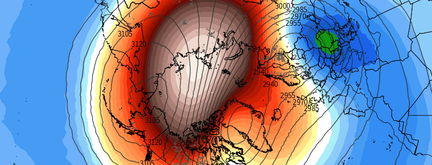
On the Polar Vortex: What is hype, what isn’t, and how it may affect us

The Polar Vortex is coming, and when it arrives it’s going to freeze you, your house, and everything around you – taking you back to the Arctic from where it came. Kidding. Ah, it has been a while since we’ve had to really dive into this. As a meteorologist, these are exciting times. The atmosphere is getting ready to put on a bit of a show, and the community is starting to pick up on it. You may recall the last time the term Polar Vortex went “viral”, back in 2014. It was a media frenzy – the polar vortex was coming to invade the United States.

You may also recall the reality of it – it was cold, and in some places it was snowy – and anomalously so. The truth is that the polar vortex is not unheard of, unthinkable, or unfathomed. It is not new, and it is not appearing for the first time since 2014. It is, however, a very neat atmospheric feature, and it deserves our full attention. It affects the weather greatly, and its positioning and intensity throughout the Winter months is a critical component of many forecasts.

Read more

From Strong El Nino to Strong La Nina?

Over the past few months, we have had an El Nino. In fact, it has been one of the strongest El Ninos on record, and is one of the reasons why this past winter was generally quite warm, and why the Pacific Jet stream was so fast and active. It also helped to trigger the historic blizzard we had on January 22nd-23rd. Currently, while we still have an El Nino at the surface, conditions are rapidly flipping towards La Nina when one takes a deeper look at the oceans, as well as the trends in the climate models.

Under “normal” conditions, where there is no El Nino nor a La Nina, the trade winds are persistent in the Equatorial Pacific, which generally blow from east to west. This “pushes” the warmest Equatorial waters further west towards Australia and Indonesia, leaving cooler waters in their wake with more upwelling of subsurface cool water as well. Over the past year or so, these trade winds rapidly weakened and even reversed in some areas, allowing warm water to flow back eastward (instead of getting forced westward) towards the entire Equatorial Pacific, spreading eastward towards Peru. As warmer water builds, Oceanic Kelvin waves, which move from west to east — but also move up (upwelling) and down (downwelling) to transport warm or cool water vertically — are able to push warm water to strong depths and generate “pools” of warm water. This allows an El Nino to sustain itself, as even when a brief period of trade wind acceleration takes place and more upwelling happens, the water upwelled is still warm. It can take months to fully reserve a new El Nino equilibrium.

But finally, the proverbial rubber band is snapping.

Read more

Increased humidity, severe storms this weekend

Low clouds have created a bit of a wrinkle in the forecast early Friday morning, owing to a southeasterly flow which developed late Thursday night. The low level inversion allowed for these clouds to push inland and develop, as seen on visible satellite imagery from Eastern Pennsylvania into much of New Jersey and New York. These clouds will eventually thin and break later Friday afternoon, as southwesterly winds take over.

Temperatures, as a result, will rebound with highs expected to reach into the upper 80’s. Rising humidity will also make it feel much more uncomfortable. The atmosphere won’t be able to efficiently mix out — so temperatures won’t rise into the 90’s on Friday and seabreezes may develop. These seabreeze boundaries could serve as a focal point for the development of some isolated storms Friday afternoon.

HRRR model forecasting highs in the 90's away from the coast on Friday, with cooler air near the shore.

HRRR model forecasting highs in the 90’s away from the coast on Friday, with cooler air near the shore.

Read more

Heat builds, severe thunderstorm risk increases

As a mid level ridge builds throughout the eastern half of the nation today, temperatures in the mid and low levels of the atmosphere will increase. South of a warm front, which is organizing and becoming more well defined to our north, west-southwesterly winds will begin to usher in the warmer airmass. Mid level temperatures (at 850mb) will warm over 17 C, and with sunshine expected during the afternoon hours on Tuesday, temperatures will warm into the upper 80’s to lower 90’s. When coupled with increasing humidity, it will feel hot and quite muggy.

Back to our west-northwest, a mid level disturbance will be riding along the northern periphery of the building ridge axis. As it does so, it will help to trigger the development of thunderstorms — some of which could be strong to severe. These storms will initially form well to our north and west, but are expected to slide east-southeastward through the Northeast States as the disturbance shifts accordingly. Subsequently, the Storm Prediction Center has placed much of the area in a Slight Risk for severe thunderstorms.

Read more