PM Update: Overnight showers/storms likely

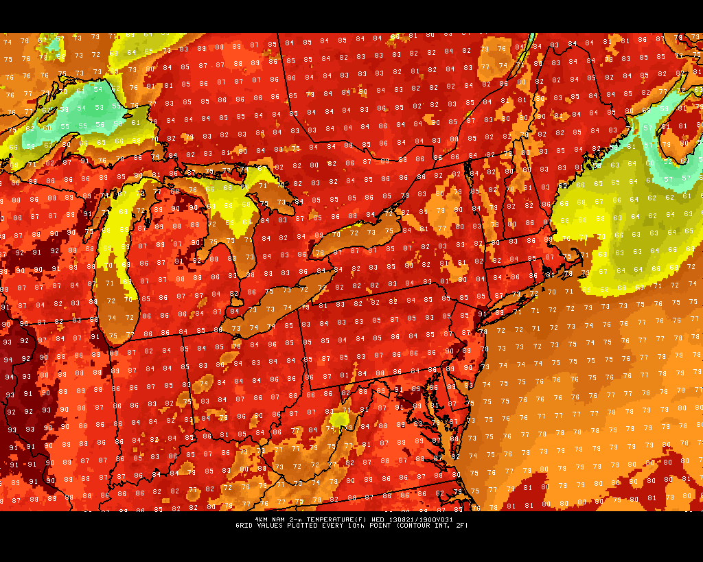
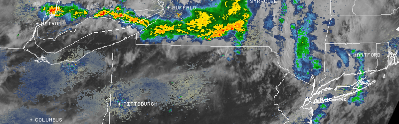
Pleasant weather, which had settled into the area over the last few days, will give way to more clouds this evening. A mix of sun and clouds had been the story today, but it had remained mostly dry throughout the area despite some widely scattered showers. However, a disturbance to our north — dropping south and east along the periphery of a mid level heat ridge over the Central US — has sparked an area of showers and thunderstorms over New York State and Northwest Pennsylvania.

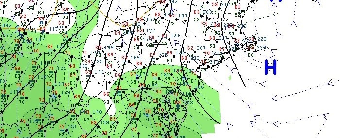
Forecast models are at odds with the overnight storms and their impact on the forecast area. A low pressure system is forecast to develop along a weak frontal zone over New England by later this evening, which adds confidence to the continued southeastward motion of the showers and storms over New York State. That being said, some weakening is likely as instability is much less over New Jersey and Southeast New York than it is currently over New York State. This lends confidence to the fact that showers will impact the area later tonight, but strong/severe thunderstorms look unlikely.

The Storm Prediction Center maintains a 5% risk for severe weather (less than a Slight Risk), for the potential of an isolated strong wind gust in any thunderstorm. Bring an umbrella if you’re headed out tonight, especially after the evening commute.

Tonight: Partly to mostly cloudy, becoming mostly cloudy with showers and thunderstorms likely. Chance of precipitation 70%. Low temperatures in the upper 60’s to lower 70’s. The evening commute should remain dry, but overnight looks wet.

Tuesday: Scattered showers early, becoming partly cloudy with a high in the middle 80’s. West winds around 5 miles per hour. The wet weather early on will give way to rapidly warming conditions. Depending on the amount of sun, some areas could approach 90 degrees.


Summer Makes Its Brief Return and Fall Weather Returns this Weekend

After what has been a very cool August with fall-like temperatures, the NYC Metro area has a chance to do something that has not been done yet this month: hit 90 degrees! The rest of today will feature temperatures in the mid to upper 80s with humid conditions, due to a warm, moist southwesterly flow, as some west Atlantic ridging has built back into the region. It’s not nearly to the same extent as earlier in the summer when we had record heat and humidity, but it’s certainly enough to make it feel like summer again.

With clear skies and calm winds for tonight, temperatures will drop pretty quickly through the evening, due to radiational cooling. Certainly a great evening for a beach or boardwalk stroll, as temperatures will drop into the low to mid 70s during the evening. Overnight lows will be in the mid to upper 60s for most of the region. With temperatures dropping pretty quickly towards the dewpoints, some patchy fog is possible late tonight and for early commuters tomorrow morning.

The high-res 12z NAM shows highs approaching 90 for parts of the region tomorrow afternoon.

The high-res 12z NAM shows highs approaching 90 for parts of the region tomorrow afternoon.

Tomorrow: Looks pretty similar to today. It will be sunny, and there may be a few isolated spots that hit 90 degrees, as the 12z 4-km NAM shows, especially in more urban NE areas of New Jersey — closer to Newark. The Rutgers Gardens weather station in New Brunswick may also hit 90 degrees — something that has not happened all month! NYC has an outside shot of 90 degrees as well, but they may end up staying in the upper 80s. Long Island will probably rise into the mid to upper 80s before a seabreeze sets in. It will be a bit muggy as well, really making it feel like summer, so get to the beach if you can!

As an area of high pressure slides eastward, a cold front will begin to approach for Wednesday night, increasing the southerly flow out ahead of it even more, which helps to increase clouds and humidity. Wednesday night will feature many areas not getting below 70 degrees, so it may be a good time to sleep with the ACs on.

Thursday: Looks to be warm and humid, but clouds will probably prevent high temperatures from reaching 90 degrees. With the cold front approaching and humidity levels on the rise, showers and thunderstorms are possible on Thursday afternoon, especially west of NYC. Any activity will slide through the region during the evening and overnight as the cold front crosses the area. Although showers and thunderstorms can be expected, severe weather potential remains low as of now, due to a lack of favorable wind profiles and wind speeds throughout the atmosphere.

Friday and the weekend: There may still be some lingering clouds and showers — especially for eastern sections — on Friday morning before skies clear. Highs should be in the low to mid 80s. Temperatures really cool off on Friday night as drier air moves in. The gorgeous, low humidity, cool weather from earlier in the month looks to return for the weekend, with lows in the low 60s and highs in the upper 70s, with sunny skies. Perhaps even some spots will see 50s for lows.

Enjoy the summer-like week and the fall-like weekend, everyone!

Unsettled weather, and the return of the Perseids

20130807-100653.jpg

7 days into the month of August, and the general feeling in the air has been more autumn-like than anything else. How many times in the past several years have we been able to say that? Well, very few is the simple answer — Augusts have averaged much warmer and more humid than the first week of 2013’s. That being said, these things have a funny way of balancing themselves out. “Climo (climatology) will always catch up” is the famous saying throughout meteorology. We’ll see if it applies this month.

One thing is for sure, the low humidity and sun-filled weather of the past several days is on the way out. It’s hard not to notice it already this Wednesday morning. The culprit? A high pressure system (the one responsible for the gorgeous weather) is slipping offshore. As a result, surface winds have turned southeasterly — off the ocean waters. Moisture will slowly increase over the next 12-24 hours. The rain may hold off until the evening on Wednesday, as the atmosphere still needs some work (namely more moisture content) to be able to produce precipitation.

By Thursday, the atmosphere will have moistened up – and an approaching warm front will provide isentropic lift and promote the development of showers and thunderstorms. Much of the same is expected through Friday, with precipitable water values approaching 2″ by Friday near and ahead of a cold front.

Some more pleasant weather is on the horizon this weekend behind the front, but we have a few days of cloudy and stormy conditions to get through before we can enjoy the warm sun once again.

Perseid’s return to light up the night sky: The annual Perseid meteor shower returns over the next week – and stargazers will be excited to learn that this years shower once again looks promising. The shower actually began a few days ago, and will continue to increase in numbers each night until a peak between August 11th-13th. Clouds will obstruct any meteor viewing through Friday, but this weekend could offer some prime-time viewing. Stay tuned for more updates as the peak approaches!