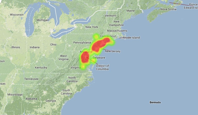
Widespread reports of a fireball, seen streaking through the sky last night around 830pm, continue to funnel in this afternoon. The American Meteor Society says they have recieved 71 official sighting reports of the meteor. Based on those details, they have concluded that the meteor entered the skies over New Jersey at 8:25pm, moving north-northwestward and eventually landing somewhere in Lancaster County, Pennsylvania. The data remains preliminary and the investigation into the event continues. The heat map, pictured below, shows the frequency of reported meteor sightings throughout the Northeast US.
Heat map of reported meteor sightings from October 14, 2013. Courtesy American Meteor Society.
https://www.nymetroweather.com/wp-content/uploads/2024/02/Empire-2000-x-300-px-2.png00John Homenukhttps://www.nymetroweather.com/wp-content/uploads/2024/02/Empire-2000-x-300-px-2.pngJohn Homenuk2013-10-15 15:24:282013-10-15 18:10:44Fireball reported, ISON and Orionid updates
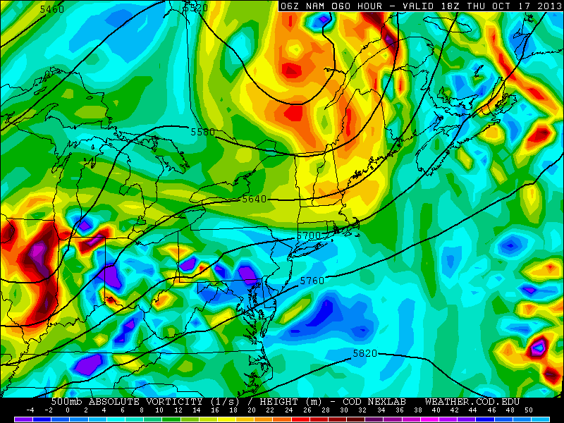
Despite the fact that pleasant weather has essentially dominated late summer and Autumn thus far, the pattern of late has trended a bit more unsettled. This is fairly typical for this time of year, as the first signs of wavelength changes are beginning to be seen in the atmospheric pattern and jet stream. However, a more dramatic pattern change is being forecast by most models in the medium range — with noticeable wave amplification throughout the Northern Hemisphere. In the short term, unsettled weather will begin to impact the area as early as Wednesday with a weak system meandering offshore beginning to back towards a coast slightly. Another frontal system back to our west will eventually approach and cross the area around mid-week, bringing in the first of several shots of cooler air.
NAM model showing multiple disturbances in the mid levels (500mb) of the atmosphere later this week.
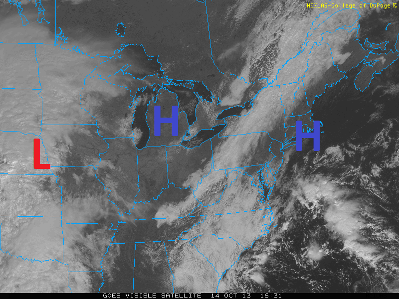
On this Columbus Day afternoon, our area is seeing lovely fall weather with temperatures in the mid 60s, and a few mid and upper level stratus and cirrus clouds off to the west.
High pressure over the area is giving us nice weather. The Low pressure in the Plains will affect us later this week.
This is in large part thanks to the high pressure system that has settled in over our area, as seen in the above image. Sunny skies with thin clouds off to the west will continue for the rest of this afternoon. The high pressure is promoting some easterly flow off of the Atlantic, helping to usher in cool air off of the ocean — which is why temperatures will struggle to get out of the mid 60s.
The thin clouds are caused by a weak frontal system off to the west associated with the thin band of clouds in Upstate NY and Central PA. This front will dissipate as it heads east, but not before bringing in a few additional mid-level clouds for tonight. This will keep temperatures from really plummeting — lows should be in the upper 40s in cool spots, with low to mid 50s elsewhere.
Tomorrow looks to be a bit warmer thanks to the high pressure system in the Great Lakes building in. Winds will have a bit more of a westerly component, helping to create some downsloping, yielding temperatures around 70 degrees.
The forecast becomes a bit tricky starting on Wednesday, as the low pressure system in the Plains approaches the area and an inverted trough develops offshore. Clouds will be on the increase for Wednesday, and the inverted trough may help to spark a few showers for Wednesday well ahead of the front. Highs should approach the lower 70s. The front itself should cross the area for Wednesday night and Thursday morning, perhaps giving the area a a brief bout of steady rain — though the heaviest rain should be to the north and west of our area.
https://www.nymetroweather.com/wp-content/uploads/2024/02/Empire-2000-x-300-px-2.png00Doug Simonianhttps://www.nymetroweather.com/wp-content/uploads/2024/02/Empire-2000-x-300-px-2.pngDoug Simonian2013-10-14 14:16:302013-10-14 14:24:12Nice fall weather today and tomorrow, scattered showers to end the week, potential pattern change to colder weather next week
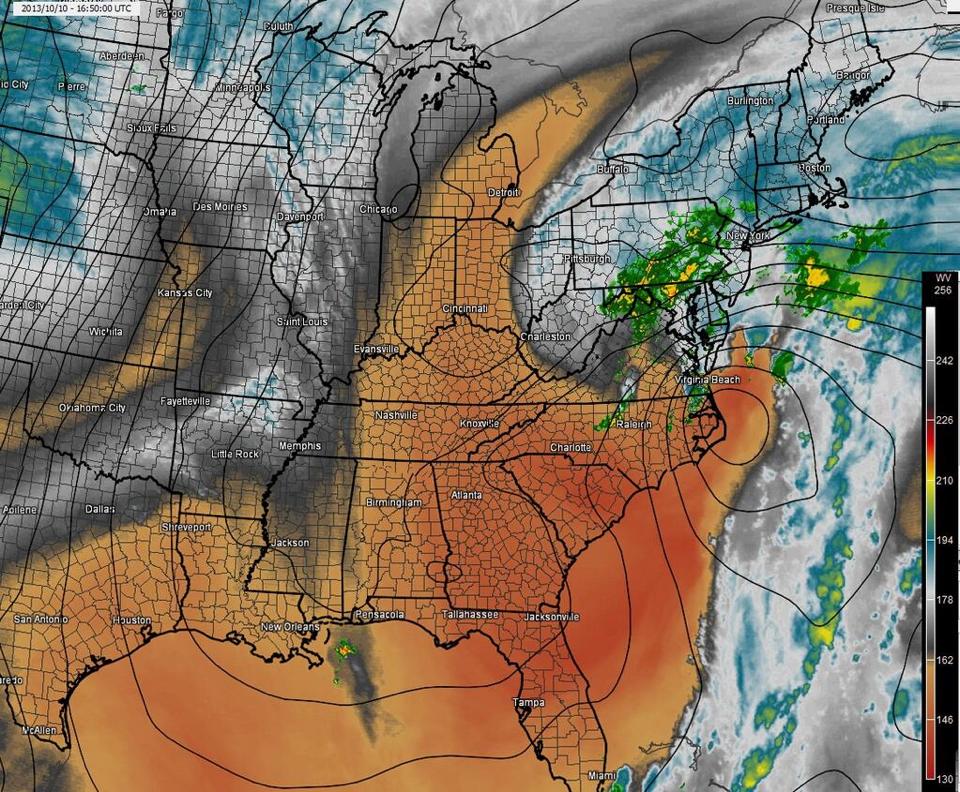
After a brief bout of rain this morning, most of the area is currently in a dry-slot. Lots of dry air has filtered into the region thanks to a high pressure system to the north. And considering the storm is still well to the south of the area, there is not enough lift in the atmosphere at our latitude to consistently supply rain. This is why our forecast called for the heaviest rain to be tonight and tomorrow morning, rather than today.
The water vapor imagery shows dry air filtering into our storm system, but lots of cold cloud tops to the east that will eventually head our way.
Hi friends! Our website uses cookies to provide an optimal browsing experience for you. New "Cookie Consent" laws mandate us to inform you of this. As long as you're cool with it, just hit OK. You'll only see this message once.
We may request cookies to be set on your device. We use cookies to let us know when you visit our websites, how you interact with us, to enrich your user experience, and to customize your relationship with our website.
Click on the different category headings to find out more. You can also change some of your preferences. Note that blocking some types of cookies may impact your experience on our websites and the services we are able to offer.
Essential Website Cookies
These cookies are strictly necessary to provide you with services available through our website and to use some of its features.
Because these cookies are strictly necessary to deliver the website, refusing them will have impact how our site functions. You always can block or delete cookies by changing your browser settings and force blocking all cookies on this website. But this will always prompt you to accept/refuse cookies when revisiting our site.
We fully respect if you want to refuse cookies but to avoid asking you again and again kindly allow us to store a cookie for that. You are free to opt out any time or opt in for other cookies to get a better experience. If you refuse cookies we will remove all set cookies in our domain.
We provide you with a list of stored cookies on your computer in our domain so you can check what we stored. Due to security reasons we are not able to show or modify cookies from other domains. You can check these in your browser security settings.
Other external services
We also use different external services like Google Webfonts, Google Maps, and external Video providers. Since these providers may collect personal data like your IP address we allow you to block them here. Please be aware that this might heavily reduce the functionality and appearance of our site. Changes will take effect once you reload the page.
-2")