Often, meteorologists pay close attention to the progression of the pattern very early in the Spring season. Although not backed by any statical research, it is often found that the patterns and trends in regards to frontal boundaries and airmass progression early in the Spring season can foreshadow how those very same boundaries will behave later in the season. This year has been no exception.
Early this Spring, warm fronts struggled to move northward from the Mid Atlantic, yielding instead to the cooler ocean waters and troughiness to our north and east. This very same thing occurred this past weekend, as warm front struggled northward from the Washington, DC area. Additionally, backdoor cold fronts have had plenty of push towards our area from New England — with marine air overtaking the pattern. This very same thing will occur on Tuesday, temporarily pushing out the warm airmass in place on Monday.
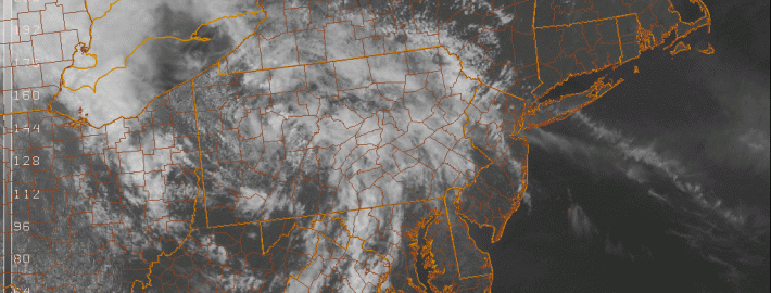
https://www.nymetroweather.com/wp-content/uploads/2014/05/vis0-3.gif8191024John Homenukhttps://www.nymetroweather.com/wp-content/uploads/2024/02/Empire-2000-x-300-px-2.pngJohn Homenuk2014-05-12 13:14:282014-05-12 13:14:28Warm, but unsettled weather this week
As the Spring season moves along, signs begin to become more clear regarding the development of an El Nino. Although there has been relatively high confidence in the development of an El Nino for quite some time, there was still a small bit of doubt, as some expressed skepticism. However, over the last month or so, the atmosphere has undergone changes which should remove any seeds of doubt regarding whether an El Nino will be developing this Spring and Summer. The only doubts that exist now is the final strength of the event (El Nino events usually peak in the Autumn): high-end moderate/low-end strong, a strong event, or a super strong event. For more information regarding the formation of El Ninos and what they mean for our weather pattern, check out the article we published last month.
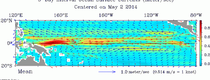
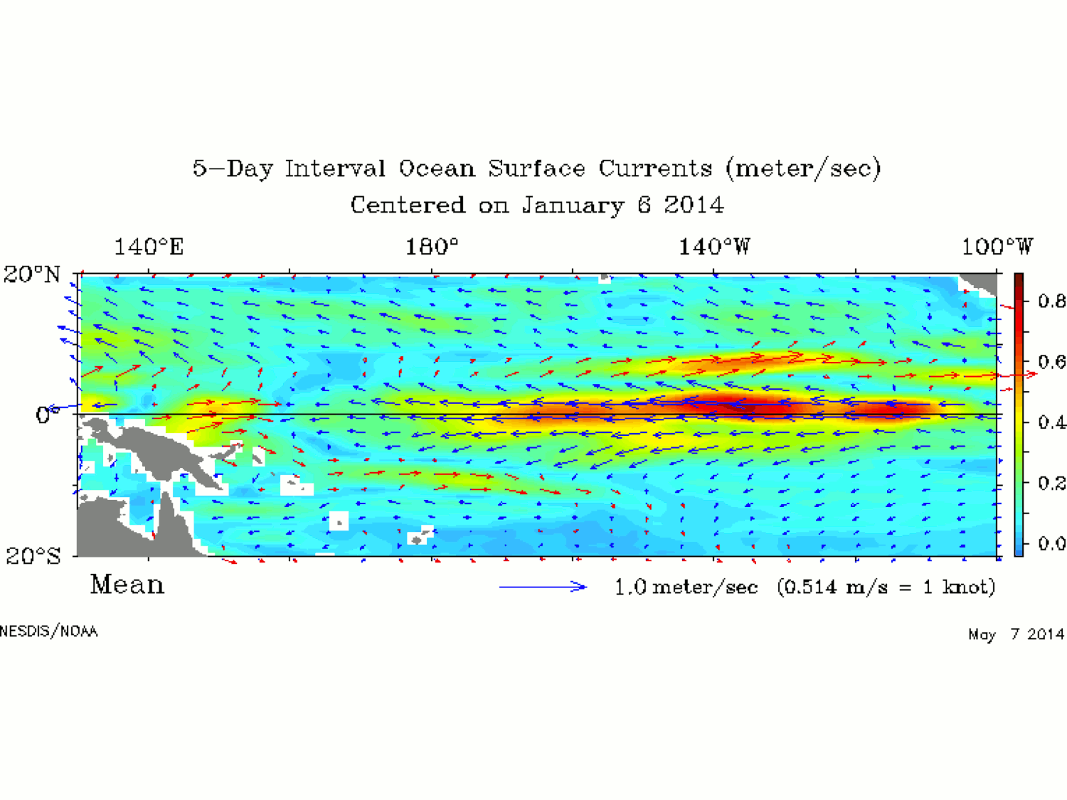
What has happened that makes us so confident? The easterly trade winds which usually keep warm water well to the west towards Indonesia have shifted to westerlies.
This animation shows the progression of the strength and direction of wind currents. Note how they started off blowing from east to west (easterlies, blue arrows), but have dramatically shifted in the opposite direction (westerlies, red arrows). This is a strong indicator that an El Nino is coming. Click to animate.
This means that the base state of the atmosphere which prevents El Nino events has completely changed to one that favors El Nino events. The typical climate pattern has easterly trade winds along the Equator, which blow warm water along the Equatorial Pacific to the west, towards Indonesia and Australia, leaving the rest of the Equatorial Pacific relatively chillier. Now that the surface currents have shifted to blowing from west to east, it becomes much easier for that same warm water from the west to move eastward throughout the rest of the Equatorial Pacific, leading to an El Nino.
https://www.nymetroweather.com/wp-content/uploads/2014/05/161.gif329810Doug Simonianhttps://www.nymetroweather.com/wp-content/uploads/2024/02/Empire-2000-x-300-px-2.pngDoug Simonian2014-05-12 07:00:352014-05-12 13:21:01El Nino Update: Not a matter of if, but how strong
As a warm front struggles to move north of the area today, temperatures have struggled as well — staying generally stuck in the mid 50’s for the majority of the day through the early afternoon. Although some warmer temperatures are anticipated by later this afternoon, the general theme will continue to feature east/northeasterly winds off the ocean waters and cooler than normal temperatures with clouds. A warm front has established itself to our south and west, and while that is providing much of the Mid-Atlantic with warmth, it is leaving us in a damp, marine airmass.
This front will struggle northward over the next few days, but the good news is that forecast models agree it will eventually make it. Friday looks to feature conditions more similar to Thursday than the past several days of this week — although there won’t be as many clouds, temperatures won’t reach much past the 60’s. This will be especially true near the coast, as east/northeasterly winds again bring in cooler marine air.
https://www.nymetroweather.com/wp-content/uploads/2014/05/temp2.gif8191024John Homenukhttps://www.nymetroweather.com/wp-content/uploads/2024/02/Empire-2000-x-300-px-2.pngJohn Homenuk2014-05-08 13:14:542014-05-09 11:37:30Slow but persistent warmup the next several days
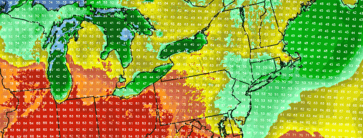
Although an area of persistent troughing which has kept the area chilly this spring has remained in place, a high pressure system to our north led to downsloping westerly and northwesterly winds this afternoon. This warmed temperatures up to around 70 in most of the area, while keeping the atmosphere very dry, with dewpoints in the low 30s. The dry conditions in combination with the trough that is still in-place will allow temperatures to drop pretty quickly tonight, as areas in the interior could have temperatures falling into the upper 30s, and frost is possible. Elsewhere, low temperatures will probably fall in the 40s — still definitely chilly enough for the light jacket tonight.
Starting tomorrow, the weather pattern will begin to change. Warmth and moisture from the south and west will try to push towards our area, while the troughing will remain to our north and east. This will create a battleground, and a resulting warm front.
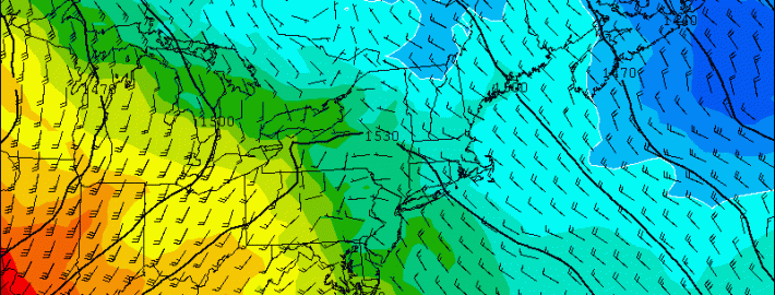
The above image shows the frontal boundary pretty clearly — the front is shown more clearly at the 850mb level, since surface temperatures are a bit more uniform due to continued downsloping flow. This will once again make surface temperatures a bit warmer for tomorrow than what they normally would be in our otherwise cooler airmass. This will allow high temperatures to approach 70 degrees again. Warm 850mb temperatures result in the potential for greater warmth given sunshine, but that potential is not always realized — and this is where the forecast becomes a bit more tricky for later in the week, which will be illustrated shortly.
Where the strong southwesterly flow at 850mb meets with the much lighter winds, is the general location of the frontal boundary, further illustrated by the strong temperature gradient. The continued northwest flow on the cold side of the boundary at 850mb will help keep things dry tomorrow, but once those southwest winds from 850mb approach in association with the front, our 850mb temperatures will rise, and the moisture in the atmosphere will increase significantly. This allows for the chance of showers and potentially even a thunderstorm on Wednesday night into Thursday morning. The warmer airmass will not allow temperatures to fall as much, as they will remain around 50.
https://www.nymetroweather.com/wp-content/uploads/2014/05/1.gif600800Doug Simonianhttps://www.nymetroweather.com/wp-content/uploads/2024/02/Empire-2000-x-300-px-2.pngDoug Simonian2014-05-06 17:49:242014-05-09 11:37:01Pleasant for now, showers later this week, warming trend this weekend
Hi friends! Our website uses cookies to provide an optimal browsing experience for you. New "Cookie Consent" laws mandate us to inform you of this. As long as you're cool with it, just hit OK. You'll only see this message once.
We may request cookies to be set on your device. We use cookies to let us know when you visit our websites, how you interact with us, to enrich your user experience, and to customize your relationship with our website.
Click on the different category headings to find out more. You can also change some of your preferences. Note that blocking some types of cookies may impact your experience on our websites and the services we are able to offer.
Essential Website Cookies
These cookies are strictly necessary to provide you with services available through our website and to use some of its features.
Because these cookies are strictly necessary to deliver the website, refusing them will have impact how our site functions. You always can block or delete cookies by changing your browser settings and force blocking all cookies on this website. But this will always prompt you to accept/refuse cookies when revisiting our site.
We fully respect if you want to refuse cookies but to avoid asking you again and again kindly allow us to store a cookie for that. You are free to opt out any time or opt in for other cookies to get a better experience. If you refuse cookies we will remove all set cookies in our domain.
We provide you with a list of stored cookies on your computer in our domain so you can check what we stored. Due to security reasons we are not able to show or modify cookies from other domains. You can check these in your browser security settings.
Other external services
We also use different external services like Google Webfonts, Google Maps, and external Video providers. Since these providers may collect personal data like your IP address we allow you to block them here. Please be aware that this might heavily reduce the functionality and appearance of our site. Changes will take effect once you reload the page.
-2")