Meteor showers come and go annually, often timed with the seasons. The Leonids, Perseids, and Quadrantids are staples in the calendar. Accordingly, many have become accustomed to not only the meteor showers timing — but the rate at which meteors fall (per hour) during each shower. Some even are able to recognize and remember where in the sky, or the constellations, from which the meteors radiate from. But what happens when an entirely new meteor shower comes into the picture, with the potential to reach “storm” level?
Enter: The Camelopardalid Meteor Shower, peaking on the night of May 23 – 24 2014
Doesn’t quite roll off the tongue. The new meteor shower was discovered and timed by scientists last year — and was known to be possible before that. It is occurring, as most meteor showers do, due to the Earth passing through the debris path of a comet. For instance, Earth has been passing through Comet Swift-Tuttle debris to create the Perseid meteor shower for thousands of years. This time, it’s Comet 209P/LINEAR which is causing the meteor shower — and Earth has never crossed paths with its debris before. (Featured image, meteor captured during the Eta-Aquarid meteor shower in 2013 by Justin Ng.)
https://www.nymetroweather.com/wp-content/uploads/2014/05/eta-aquarid-meteor-justin-ng.jpg6831024John Homenukhttps://www.nymetroweather.com/wp-content/uploads/2024/02/Empire-2000-x-300-px-2.pngJohn Homenuk2014-05-20 13:20:502014-05-21 08:12:08New, major meteor shower possible May 23-24
After plenty of rain on Friday, a cold front crossed the region, drying our weather and leading to a pleasant weekend. This trend is expected to continue through Tuesday, but conditions will start to deteriorate on Wednesday.
The two main features dominating our weather pattern currently are a surface high pressure just to our west, and an upper level cold pool over New England.
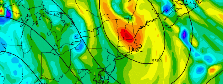
When the cold front crossed the region, a surface high pressure system built in, as is typical behind a cold front, leading to plenty of sunshine. This sunshine heats the ground quite efficiently. However, the passage of the cold front was also associated with a large upper level cold pool of air. The featured image above this post shows Monday’s NAM at 500mb valid for 2:00pm this afternoon shows a closed contour/trough of lower heights (cold air) centered directly over New England. This will help to generate cold temperatures in the middle and upper portions of the atmosphere, leading to instability (weather.cod.edu)
This cold pool does two things: it reinforces westerly and northwesterly winds behind it, which generates a downsloping flow, helping to warm our daytime temperatures to just below average, despite the chilly airmass and chilly nights behind the cold front. While this downsloping flow initially also helps to provide a lot of sunshine, the fact that we now have sun heating the ground beneath very cold upper level temperatures generates plenty of atmospheric instability, allowing air to rise quickly, generating clouds. This is called self-destructive sunshine — the sun heating the ground generates the warmth at the ground and the instability to generate clouds — this is typical when we are under the influence of an upper level cold pool, and explains why at times we had plenty of dark, cumulus clouds on Sunday afternoon, after an initially clear sky.
Monday’s weather: This cold pool will actually be a bit stronger than it was on Sunday, as the 500mb heights show a closed off contour, whereas on Sunday, it was still an open trough. Thus, although Monday’s weather should be very similar to Sunday’s in that the day will start off beautiful, but have an increase in cumulus clouds during the afternoon, the cumulus clouds may actually result in a few scattered showers this time around. The showers should be light and isolated in nature, however, so an umbrella should still not be needed.
Regardless, high temperatures should be in the upper 60s to lower 70s — even at area beaches since the downsloping westerly and northwesterly winds will block any seabreezes. Winds may pick up during the afternoon, however, being sustained at 10mph with some gusts to 20mph, because of strong atmospheric mixing that occurs when we have unstable conditions — the stronger winds from just above the ground can “mix” with the surface, generating stronger winds.
Moving forward to tonight and Tuesday: the upper level cold pool will slowly move out to sea, helping temperatures warm a tad. Read more
https://www.nymetroweather.com/wp-content/uploads/2014/05/12.gif600800Doug Simonianhttps://www.nymetroweather.com/wp-content/uploads/2024/02/Empire-2000-x-300-px-2.pngDoug Simonian2014-05-19 07:00:142014-05-20 12:43:12This week’s outlook: Pleasant start, unsettled middle and end
A slow-moving cold front, along with a weak warm front that crossed the region on Thursday, will combine to create interesting changes to our weather — namely the potential for heavy rain on Friday afternoon. The warm frontal passage brought the introduction of a warmer, moist airmass — increasing dew points and precipitable water values. As the cold front shifts toward the area during mid-day on Friday, lifting in the atmosphere will gradually increase which will help to generate heavy rain and even the chance of a thunderstorm come Friday Night.
A large ridge in the Western Atlantic will act to provide plenty of clockwise flow increasing our warmth and moisture. Additionally, to the west, we have a potent trough and associated cold front with plenty of lift. The large ridge is what initially makes the front slow to move eastward, prolonging our fetch of moisture. This is a weather pattern we had often during the beginning of last summer, which is why we had such humid conditions. The initial slower movement of the cold front will keep the heaviest rain to the west of our area during the morning on Friday — but a slow shift eastward is expected. Read more
https://www.nymetroweather.com/wp-content/uploads/2014/05/111.gif600800Doug Simonianhttps://www.nymetroweather.com/wp-content/uploads/2024/02/Empire-2000-x-300-px-2.pngDoug Simonian2014-05-15 16:46:462014-05-16 08:43:17Foggy Friday followed by heavy rain Friday night
The backdoor cold front which we discussed a few days ago lived up to expectations throughout the area this week. Although not exciting by any means, the front brought cooler air and more clouds as it was expected to — essentially ending the brief period of warmth which saw temperatures on Monday reach into the mid 80’s. The east winds off cooler ocean waters are expected to keep temperatures in the 50’s and 60’s on Wednesday. Additionally, some low level moisture could lead to drizzle in many places, adding to the damp and dreary feel already in the air.
As a storm system approaches our area from the west later this week, the backdoor front will begin to lose some of its grip on the area’s weather. But the damage will have already been done in terms of spoiling what otherwise would’ve been a glorious period of warmth. Thursday looks likely to feature warmer temperatures in the 60’s and 70’s, but a continued trend of unsettled weather including clouds and some showers thanks to a southeasterly wind direction.
Hi friends! Our website uses cookies to provide an optimal browsing experience for you. New "Cookie Consent" laws mandate us to inform you of this. As long as you're cool with it, just hit OK. You'll only see this message once.
We may request cookies to be set on your device. We use cookies to let us know when you visit our websites, how you interact with us, to enrich your user experience, and to customize your relationship with our website.
Click on the different category headings to find out more. You can also change some of your preferences. Note that blocking some types of cookies may impact your experience on our websites and the services we are able to offer.
Essential Website Cookies
These cookies are strictly necessary to provide you with services available through our website and to use some of its features.
Because these cookies are strictly necessary to deliver the website, refusing them will have impact how our site functions. You always can block or delete cookies by changing your browser settings and force blocking all cookies on this website. But this will always prompt you to accept/refuse cookies when revisiting our site.
We fully respect if you want to refuse cookies but to avoid asking you again and again kindly allow us to store a cookie for that. You are free to opt out any time or opt in for other cookies to get a better experience. If you refuse cookies we will remove all set cookies in our domain.
We provide you with a list of stored cookies on your computer in our domain so you can check what we stored. Due to security reasons we are not able to show or modify cookies from other domains. You can check these in your browser security settings.
Other external services
We also use different external services like Google Webfonts, Google Maps, and external Video providers. Since these providers may collect personal data like your IP address we allow you to block them here. Please be aware that this might heavily reduce the functionality and appearance of our site. Changes will take effect once you reload the page.
-2")