Strong thunderstorms possible this afternoon

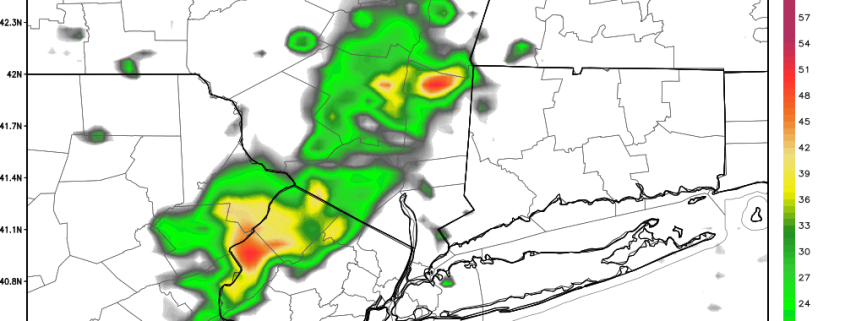
After a heavy soaking of much-needed rainfall for much of the area, we have a temporary lull in the action. Central Park received 1.16″ of rain, while JFK received 1.12″ — most areas had around or just over an inch of rain, including Long Island where a moderate drought had been present.

The initial more widespread area of rainfall had been from a warm front, but that has since moved through, except in Suffolk County where another band of rain will be hitting from the Atlantic. The next area of forcing for precipitation is from a cold front, which is still off to the west in Central Pennsylvania, thus the current break in precipitation.

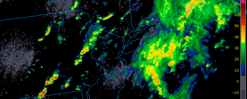
With all of the low-level moisture, temperatures warming up a bit, the cold front back to the west, and fast mid and upper level winds from a rigorous trough, there is a decent instability and wind shear juxtaposition for strong thunderstorms. Hail does not look look to be a threat, as updrafts will not be strong enough to generate hail stones, but a line or cluster of thunderstorms that produce wind gusts over 40mph is possible as we head towards the late-afternoon hours. Severe weather looks unlikely, as the instability is not quite strong enough for the thunderstorms to reach those levels.

Today's NAM Model valid for 5:00pm shows a decent combination of moisture, wind shear, and instability for strong thunderstorms.

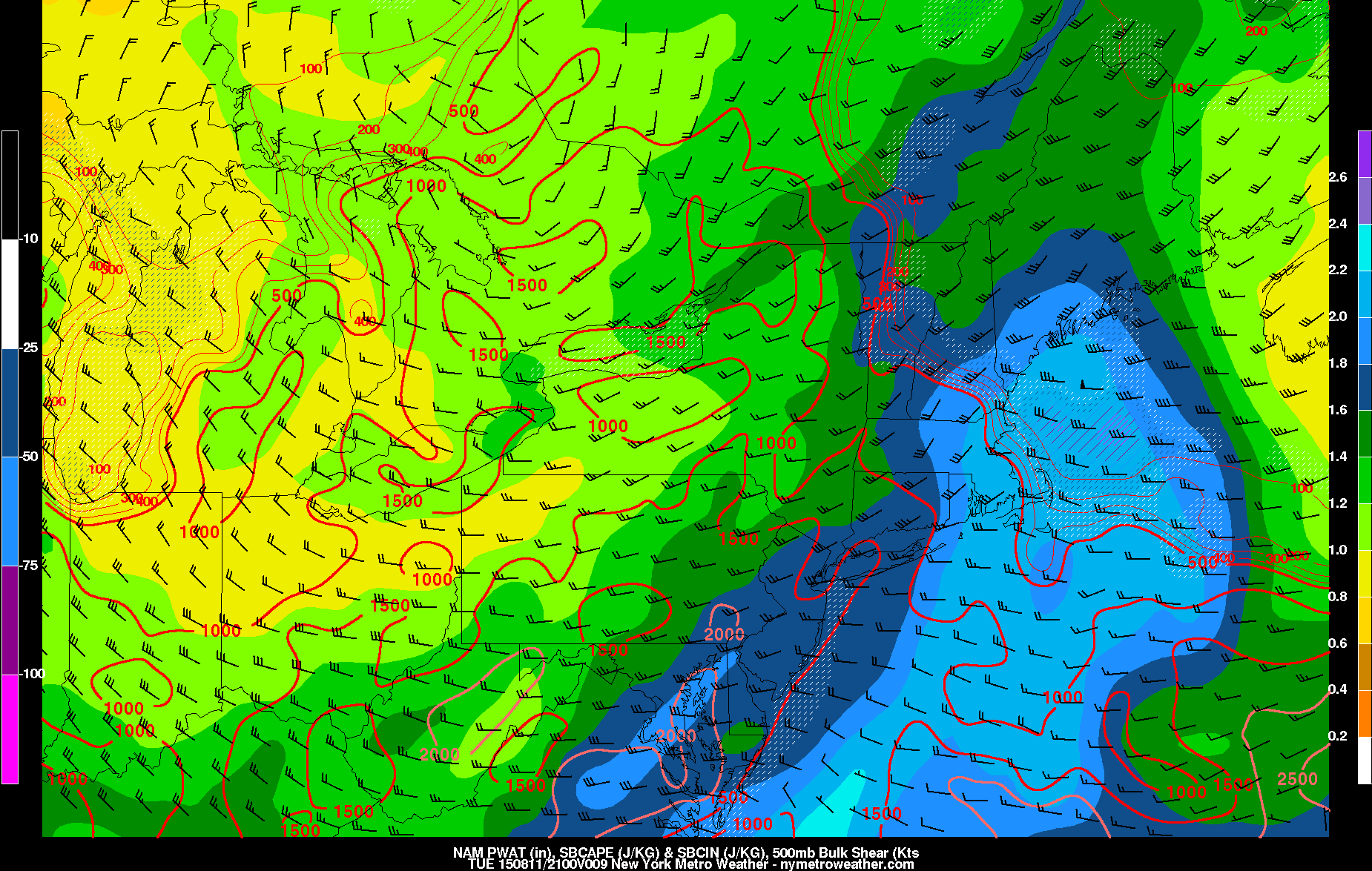
Today’s NAM Model valid for 5:00pm shows a decent combination of moisture, wind shear, and instability for strong thunderstorms.

Moisture will gradually be lessening as the afternoon goes on, but there will still be enough for heavy downpours and perhaps some urban flooding in any thunderstorms. The persistent, widespread heavy rainfall, however, is over, as any heavy rain will be a lot more scattered. The cold front will cross the area later this evening, drying things out and leading to a lovely Wednesday.

Coastal storm expected to skirt offshore this weekend

This mornings operations at the forecast desk could almost be mistaken for mid-winter. All kidding aside, forecast models have jumped around over the past several days in regards to the track and intensity of a coastal storm system which is now expected to pass just barely south and east of our area on Friday. The storm itself is forming due to an energetic mid level atmospheric disturbance, which will drive southeastward into the Mid Atlantic states later today and Friday. This will aid in the development of a surface low pressure system, and plenty of atmospheric moisture will help develop precipitation across the Mid Atlantic States.

Perhaps most notable is the fact that this atmospheric energy is undercutting a very fast atmospheric flow to its north, over the Great Lakes and New England. This means that the storm system won’t have much room to move northward — and its development will be shunted to the east instead of expanding northward and westward. Fast northwesterly winds aloft will keep the pattern moving, especially over New England. So the low pressure system at the surface will respond accordingly, developing from the Mid Atlantic and then seaward toward the Western Atlantic Ocean.

Read more

Morning Roundup: Pleasant today, Nor’Easter stays seaward

A little over twenty four hours ago, many locations in our area had quite the strong thunderstorm, and it even strengthened to severe levels once it hit Suffolk County. Large tree damage was a common occurrence in Suffolk County, and a 1.75″ hail report was made from Mount Sinai, well above the 1.00″ criteria for severe hail. Newark, NJ gusted to 51mph while most of the rest of us still saw wind gusts over 40mph with vivid lightning.

Fortunately, weather did not interrupt our sleep this time around, unless you were pulling an all-nighter to enjoy falling dewpoints and clear skies. A cold front crossed the region yesterday evening, giving way to high pressure, sunny skies, and low humidity. Today is setting up to be a nice day as northwest downsloping winds will help us reach the upper 80s to around 90 for high temperatures, even along the shores. Some high-resolution models are forecasting a couple of isolated showers and thunderstorms this afternoon, as a weak, moisture-laden shortwave passes through. These are unlikely given the stable atmosphere aloft, and these models can sometimes be trigger-happy, but given the shortwave passage we will be keeping an eye out. Regardless, a few cumulus clouds are possible in the afternoon. Winds will generally stay light, but could occasionally gust to 15-20mph in the afternoon.

Here are some other weather highlights:

  • Clear skies, dry conditions, and diminishing winds will lead to radiational cooling tonight. Thus, most inland locations and the Pine Barrens will fall into the 50s tonight/tomorrow morning, though other areas including more Urban areas will fall into the mid 60s.
  • A bit cooler of an airmass is expected for Thursday with less downsloping flow. Skies will be sunny and it will be precipitation-free, with temperatures in the low to mid 80s.
  • The Nor’Easter which previous model guidance had shown for Friday looks very likely to move out to sea. The weather pattern simply does not look amplified enough to support a storm climbing the coast. In fact, Friday now looks partly cloudy, though northeast winds from the offshore storm could hold temperatures in the low 80s, and a somewhat cool airmass behind the storm could also lead to low 80s on Saturday, with still partly cloudy skies.
  • Sunday also looks quite pleasant, so it should be a great day for afternoon baseball at Yankee Stadium. In fact, humidity may not increase again until Tuesday out ahead of the next frontal system — perhaps Monday if it speeds up, but this is unlikely. Showers and thunderstorms are likely ahead of this front.
  • An extreme heat wave is setting up in parts of Texas, as yesterday will start a string of potentially seven consecutive 100-degree days. In fact, last night’s NAM Model shows a high temperature of 108 degrees in the Texas Panhandle for tomorrow afternoon. Now those are the dog days of summer.

Afternoon Roundup: Showers and thunderstorms late tonight

The stretch of hot weather has continued into today, where temperatures could touch 90 degrees once again. For some of the warm spots, this marks the seventh consecutive 90-degree day. Most of us, however, missed out on a day or two of 90-degree temperatures, so this could be the fifth 90-degree day in seven days.

Fortunately, the past several days, including today, have been much less humid. This has helped it feel quite comfortable outside during the past few days and has also led to gorgeous nights, as many Met fans at Citi Field last night could probably attest to.

Unfortunately, however, southerly winds ahead of a cold front will be increasing later this afternoon and particularly tonight, which will help bring up some more moisture, making it feel more uncomfortable and perhaps fueling some thunderstorms.

The increase in southerly winds may actually prevent some locations along the coast from hitting 90 degrees; NYC has actually been stuck in the upper 80s, while Newark has already hit the lower 90s. Regardless, the rest of the afternoon looks mostly sunny, as any thunderstorm activity should generally remain well to the west.

Here’s what we can expect, along with other general weather highlights:

Read more