Weekend will bring improving, warmer weather

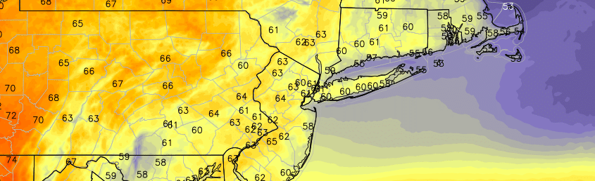
The stretch of unsettled weather this week brought about temperatures in the 60’s, with an onshore flow and marine air. Plenty of showers marred the forecast from Monday through Friday, and winds off the area waters meant more humid and cool conditions. Although we are fast approaching the summer season, this week felt more like April than anything else. Luckily, the weekend will be the start of improving conditions and a trend toward at least more seasonable temperatures.

Although winds will be variable, and the coast will remain somewhat cooler than surrounding areas, temperatures will warm into the 70’s during the day on Saturday, especially in the interior. The warm sun will be a welcomed addition to the day, after a cloudy start, given the weather we have experienced over the past week. It will certainly feel warmer than it has in a while. Southwesterly winds will eventually try to take over, and bring warmer air into the area as well.

Read more

Organized thunderstorm potential on Monday and Tuesday

If you’re here looking for an article on the general weather over the next few days and the weekend, check out our previous article. This article will focus on the potential for thunderstorms on Monday and Tuesday, some of which could be severe.

In what could be a foreshadowing of the pattern for much of the summer, a ridge will be developing in the NE Pacific, which forces a trough to enter the Great Lakes and Southeast Canada. Wavelengths are shorter in the summer than in the winter, which means that instead of that trough being forced into our area, it generally will stay to our west. This also means and gives more room for some ridging to our south and west. The incoming troughs at times can enhance southwest flow ahead of them and thus “push” or advect some of that warm and moist air into the region in the form of a warm front. This summer, in general, should thus have periods of cool and warm weather in 2-4 day periods as warm fronts bring in occasional heat and humidity, but Great Lakes troughs will keep them from being sustained and will also bring some cool weather — very few prolonged heatwaves.

Considering we will often be on the boundary ahead of the trough and just ahead of the strongest ridging, this could mean an active severe weather season for our area. And this exact scenario could be playing out to start next week — a warm front will be pushing northward, providing wind shear, warmth, and instability, while the strong trough incoming will provide chilly mid-level temperatures, height falls, and energy for lift.

Read more

Unsettled weather hangs on before the weekend

It has been an uncharacteristically cool week — at least for the standards of May. It has also been an uncharacteristically wet week. After the driest May on record at multiple reporting stations in our area, this week featured rainfall amounts of 2 to 3 inches in many areas. Some received upward of 4 inches in Northeast New Jersey. The main story over the next few days won’t necessarily be widespread heavy rain, but it will be a continuation of unsettled weather.

An onshore flow, owing to  a persistent and weakening mid level low over the Mid Atlantic States, will continue to promote the intrusion of a marine airmass from much of the Mid Atlantic into the Northeast. While some areas to the north and south of this persistent east/southeast onshore flow will see pleasant weather on Thursday, the unfortunate fact is that our area won’t be one of them.

Read more

Slight risk for strong storms this evening

The Storm Prediction Center has placed much of the area from New York City westward in a Slight Risk for severe thunderstorms this afternoon and evening. Ahead of an approaching frontal boundary, warm and humid air is advecting northward into the region. Increasing dew points and surface heating will lead to the development of moderate instability throughout the area by the afternoon hours. Accordingly, the approaching front will aid in the development of storms from Eastern Pennsylvania into Western New Jersey.

These storms will move toward a narrow axis of instability over New Jersey reaching toward New York City this afternoon. Narrow, only because east of New York City a stout marine layer will remain in place. This will keep storms elevated and weaker — temperatures there will be cooler as well with less instability. Nevertheless, the storms will march eastward through New Jersey toward NYC right around the PM Commute. The main threats with any storms will be gusty winds, lightning, and heavy rain.

This post will be updated throughout the day with the latest information including watches and warnings.

Read more