Here’s why we aren’t expecting blockbuster snow totals in NYC

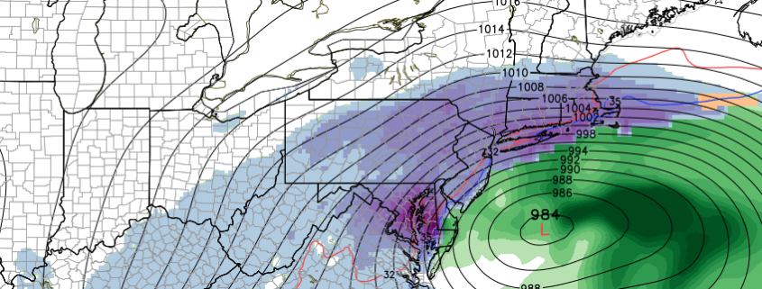
Much has been made over the past few days in regards to the potential for a major snowstorm in the Mid Atlantic and Northeast this weekend. With up to two feet of snow (possibly more in banding) expected in the Washington DC area, and the storm forecast to move at least slightly north up the Mid Atlantic coast, there have been an increasing amount of forecasts calling for prolific snowfall amounts in New York City. But forecast models over the last day or so have again begun trending southward, with a very sharp gradient in precipitation expected near the New York City Area.

In fact, further investigation of the changes on forecast models reveal several atmospheric developments that are disconcerting for big snowfall — and it seems likely that New York City will avoid the blockbuster snowfall amounts at this point. Here’s why:

Read more

Major storm likely this weekend, but uncertainties continue

Forecast models continue to slowly converge on the overall evolution of a large, powerful coastal storm which will evolve near the East Coast of the United States later this week. The agreement in regards to the storm development, on almost all global models and ensembles, is quite remarkable for this lead time. Almost every global model shows the storm system developing through the Mississippi River Valley, and eventually re-forming off the East Coast, moving northward to a position off the Delmarva. The exact track and intricacies of the atmospheric setup, however, create continued uncertainties in regards to the storms impact in our local area.

The setup actually begins to unfold later this evening, as a strong Pacific disturbance comes ashore in the Pacific Northwest. This disturbance is forecast, by all models, to drop southeastward through the Rockies, eventually to a position near the Central and Southern Plains states during the middle part of the week. During this time, another strong northern jet stream disturbance is forecast to race southeastward through the Dakotas, eventually phasing with the Pacific disturbance as it moves toward the Mississippi River.

Read more

Despite strong signal, models differ on late week winter storm

Forecast models are a complicated thing: Meteorologists know, when major storms are looming, that they can often provide major hints and clues into how the atmosphere is going to evolve. Unfortunately, many readers or the general public don’t fully understand that models should be used for guidance, and not as fact. Quite possibly, the misunderstanding stems from meteorologists inability to communicate that.

Global models over the past few days have been strongly signaling the potential for a major East Coast storm system later this week. More specifically, many of them have been signaling the potential for a significant winter storm in our area. However, closer inspection of these global models reveals several large differences — and reasons why confidence is very low in any specific storm evolution as we move forward.

Read more

Hype gaining speed with late week winter weather event

We’ll be the first to tell you: You’re probably going to see and hear a lot about a potential winter storm over the coming days. In addition to that, you probably shouldn’t take everything you hear all that seriously.

Here’s the long and short of it: Forecast models, over the past two days, have come into agreement on the idea that a significant winter weather event will evolve in the Eastern United States sometime late this upcoming week into the upcoming weekend. A strong low pressure system is forecast to develop from the South-Central United States, through the Mississippi River Valley, and eventually re-develop off the East Coast.

Read more