Sunday Overview: Warming Trend For Early This Week

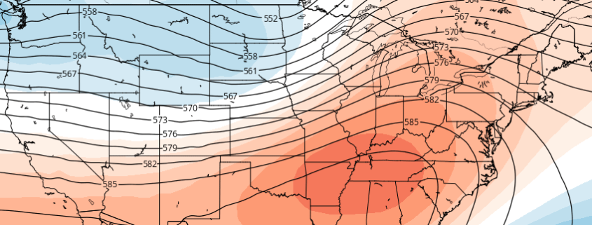
A beautiful Autumn weekend continues today, with high pressure still in control. But a warming trend will start today with more southwest winds, as high pressure begins to shift further south and east of the region. Highs will be in the upper 60 to lower 70s with plenty of sunshine today. These temperatures are already slightly above normal for this time of year. Clouds will be on the increase tonight as a weakening cold front approaches the region.  Some isolated or widely scattered showers are possible later tonight and tomorrow morning.  But with limited lift and moisture, these will likely be on light side.

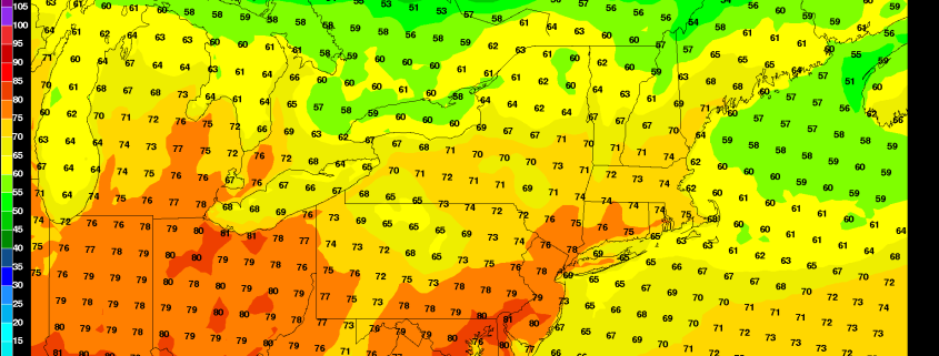
The cold front likely washout day during the day tomorrow, as ridge from the southwest, begins building over the region. Clouds should break for more sunshine by the afternoon and unseasonable warm airmass will be in the region with temperatures well above normal. West-southwesterly winds will cause temperatures to rise into middle to upper 70s to near 80 over many parts of the region tomorrow afternoon. Some other highlights, for this upcoming week:

Read more

Significant warmth across the US next week, but will it last?

The hemispheric pattern evolution over the next 7-10 days will be quite intricate, to say the least, and could potentially include both a significant — possibly record breaking — warmup, and a large scale cooldown directly behind it. The pattern changes and evolution are being largely driven by changes that are ongoing in the Pacific Ocean, as a large low pressure system and mid level trough form in the Gulf of Alaska. This forces dramatic changes to the pattern across the Continental United States.

Late this week, a large trough centered near the Aleutian Islands of Alaska will begin a dramatic shift. This trough — overall — has been centered near the Aleutians for quite some time now. But a changing pattern, wavelengths, and an extra boost from a recurving typhoon will help to bring forth the change. The Aleutians trough shifts southeast by hundreds of miles this weekend, resulting in a significant storm system pushing into the Pacific Northwest.

Read more

Monday Musings: Cold air, high pressure settles in

Behind the ever-surprising Hurricane Matthew, which offered a last-minute change in track this weekend after several before that, high pressure and more benign weather will finally settle in during this week. While many are taking the day to relax, in recognition of Columbus Day, the chill and blustery winds have the air feeling just like Autumn should, if not a bit colder compared to average.

Much of the same is expected this evening, as the cold airmass settles overhead. High pressure will bring clear skies and calming winds, which will set up ideal radiational cooling conditions throughout the area tonight. We’ve got the highlights below:

Read more

Weekend Overview: Showers Possible Saturday, Matthew Parallels the Southeast Coast

After some areas of morning patchy fog. Today turned out beautiful day with temperatures rising in the middle 70s this afternoon. Skies will remain mostly clear this evening, then clouds will increase again later tonight, as low-moisture increasing underneath an inversion. Some areas of patchy fog and drizzle could also be around again early tomorrow morning. Low temperatures tonight will drop into the 50s over most region. Closer to 60 for NYC metro and urban areas.

Read more