Sunday Overview: Warmth today followed by showers and possible t-storms this evening

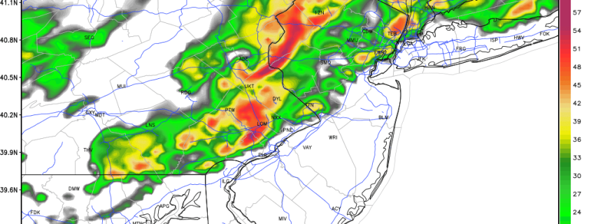
Today has gotten off to beautiful, warm start for this time of year!  A weak cold front slowly moving through the region is cause some clouds to mix with sunshine this morning. But dry conditions remain as lift is currently too weak this front. Some sunshine with more west-southwest winds, will help temperatures rise into the lower or middle 70s over much of region this afternoon. Which around 10 degrees warmer than normal for the end of October.

However, a wave of low pressure developing along the cold front will enhance more lift,-leading to more cloud cover and numerous showers around the region later this afternoon and evening. A widespread, heavy rainfall is not currently anticipated. But with the airmass becoming warmer and unstable, some showers and thunderstorms with heavy downpours and frequent lightning are possible. The Storm Prediction Center even has marginal risk for isolated thunderstorms with damaging wind gusts for parts of West-Central NJ and Eastern PA. Stay tuned for updates on our social media accounts today. Premium members, check back for more updates on this system on the main dashboard today, as well. Skies will clear later tonight, as this system moves out of the region. Some other highlights for the next few days:

Read more

Premium: November Outlook and pattern evolution

Changes in the stratosphere have been well documented and explained over the past several days and, despite the fanfare, have not yet had their dramatic impact on the weather pattern across the Continental United States. But in due time, they will, and it will likely begin — ironically — at the very start of the month of November. A much more amplified pattern in the higher latitudes will kick off changes in the Pacific Ocean, starting with a much more amplified Pacific Jet.

This Pacific Jet stream will flood the United States with warm, maritime air as a large vortex forms in the Gulf of Alaska. This is an important development for several reasons moving forward, but in the interest of November alone, its short term significance will be verified by a surge of much above normal temperatures into the Central and eventually Eastern United States.

Read more

The stratosphere, Pacific Jet, and a changing hemispheric pattern

A hemispheric pattern change is underway, and the effects will be felt throughout the United States quite quickly over the next few weeks. A dramatic change in wind speed and temperature in the stratosphere — near the very top of the Earth’s atmosphere — over the past few days, has re-shuffled the pattern throughout the troposphere — where most of our weather is observed. This is especially true in the higher elevations, nearer to the poles, where the stratospheric vortex typically resides. The disruption to the stratospheric vortex will have implications on the pattern throughout the Northern Hemisphere.

Here’s the thing: The stratospheric vortex is fickle. It extends from the troposphere to the stratosphere, so simply disrupting it or moving it won’t have dramatic implications. But what’s happened over the past few days, and what will occur through next week, is more than that — forecast models continue to indicate that the stratospheric vortex will be completely split throughout multiple levels. When the stratospheric vortex splits into two, dramatic implications can occur throughout the higher latitudes. Even if they don’t occur immediately, the splitting stratospheric vortex can lead to a domino effect which changes the pattern down the road.

Read more

How the North Pacific Ocean offers winter clues in November

With Autumn very obviously and officially underway (have you been outside this morning?), questions have begun to surface regarding the upcoming winter — and if the Autumn pattern will foreshadow it. Unfortunately, it isn’t quite as simple as “A cold October means a cold winter” or ” A warm November means a warm winter”. If that were the case, we’d have long range forecasting figured out by now, and there would be much less urgency to winter outlooks. Instead, meteorologists use “drivers”, analogs, teleconnections, and ensemble guidance to help with seasonal forecasts. When used together and properly weighted, these tools provide a higher probability of success in medium to long range forecasting. These methods are far from perfect, but can help offer us clues as to how the coming season will play out.

One major piece of the Winter’s puzzle can be found in the form of “clues” in the North Pacific Ocean. Meteorologists use different oscillations to measure the pattern in the North Pacific over time. The pattern in the Eastern Pacific Ocean is represented by the aptly named “East Pacific Oscillation” (EPO). Like the North Atlantic Oscillation (NAO) the EPO has certain generally predictable outcomes when it oscillates from positive to negative phases.

Read more