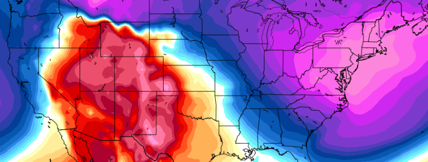
Synopsis: Arctic air drops into the Northeast US late this week, with temperatures 20 to 30 degrees below normal. A storm pattern continues with another winter storm expected this weekend. The longevity of this cold comes into question as Christmas week approaches with the return of a Southeast Ridge.
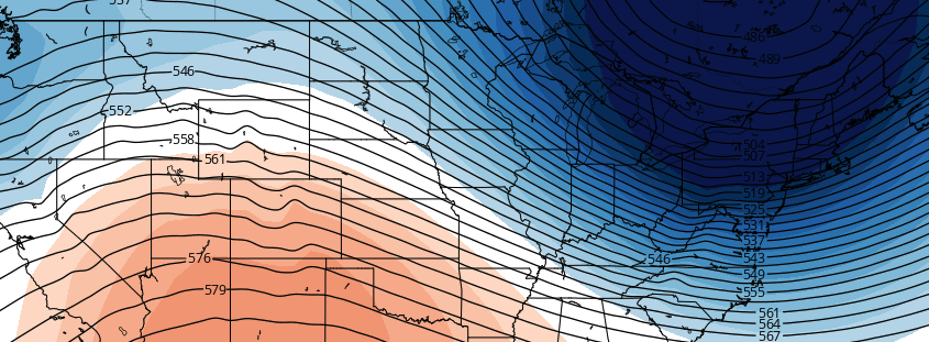
Lets face it — there has been a ton of conversation in regards to this colder pattern over the past few weeks. Our team of forecasters has been talking about it for more than a few weeks now –and it is finally arriving this week. A piece of the polar vortex (yes, the one you hear about a lot) will drop southward into Canada and eventually through parts of the Northeast states late this week. This will lead to temperatures dropping well below normal over a large part of the region.
Lets face it, the term “Polar Vortex” has become overused and oversaturated over the past few years. This time, however, it is certainly applicable: A piece of the polar vortex will be swinging southwards this week through New England, bringing with it extremely cold temperatures and an arctic airmass which is decidedly unusual for this time of year.
We spoke a few weeks ago about how the intrusion of this type of air was likely, due to the presence of a large ridge building from Alaska to the North Pole. The time has finally come, and the airmass over the Northeast US by the end of this week will feature temperatures 20 to 30 degrees below normal averages for this time of year.
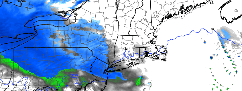
A much discussed storm system will finally make its trek east through the United States this weekend, arriving in the Ohio Valley and Northeast United States from Sunday into Monday. An initial disturbance pushes eastwards on Sunday, shearing out and weakening but still providing the impetus for some preliminary wintry weather. The more significant disturbance waits until Sunday Night and Monday to impact the Northeast US, bringing with it a significant amount of moisture and lift for precipitation. Snow is expected to shift northeastwards from the Ohio Valley gradually as Sunday evening goes on.
That’s where the complications begin: A surge of warm air associated with the system will be battling a departing high pressure, which will be on borrowed time as it moves away into the Atlantic Ocean. This spells the likelihood of mixed precipitation and transitioning precipitation types after a start as snow, especially near the coast where wintry precipitation amounts will be extremely limited. But inland, where cold air is expected to be more stout, a few inches of snow are possible before the changeover.
https://www.nymetroweather.com/wp-content/uploads/2016/12/Screen-Shot-2016-12-10-at-8.19.13-AM.png319900John Homenukhttps://www.nymetroweather.com/wp-content/uploads/2024/02/Empire-2000-x-300-px-2.pngJohn Homenuk2016-12-10 08:19:502016-12-10 08:19:50Wintry weather likely in the Northeast Sunday into Monday
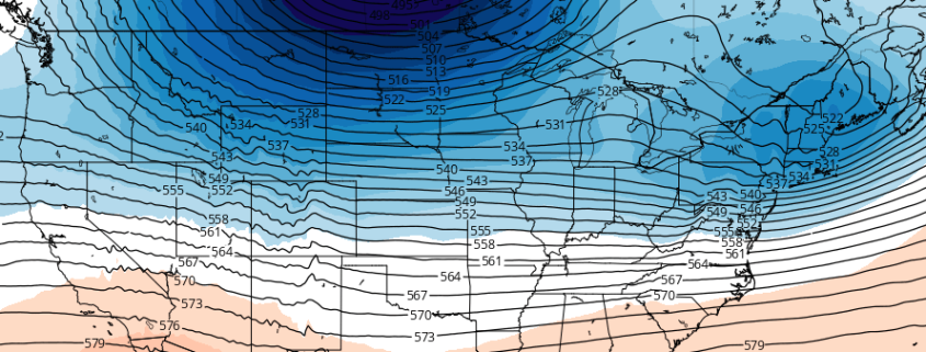
A changing hemispheric pattern will lead to the development of an active, colder regime across the Northern 1/3 of the United States. Changes are already afoot, and are expected to continue developing through this weekend. A large ridge building near Alaska will begin forcing arctic air southwards into Canada, suppressing the jet stream in the United States and allowing colder air to seep into the Northern 1/3 of the country.
An active jet stream pattern is expected to continue to bring disturbances into the United States with relative frequency. The first arrives late this weekend into early next week, and forecast models have come into relative agreement on the storm system’s evolution. There are still considerable uncertainties regarding track and intensity, all of which will have major impacts on sensible weather.
https://www.nymetroweather.com/wp-content/uploads/2016/12/Screen-Shot-2016-12-08-at-12.32.04-PM.png338913John Homenukhttps://www.nymetroweather.com/wp-content/uploads/2024/02/Empire-2000-x-300-px-2.pngJohn Homenuk2016-12-08 12:32:412016-12-08 15:45:53First in a series of wintry events likely late this weekend
Hi friends! Our website uses cookies to provide an optimal browsing experience for you. New "Cookie Consent" laws mandate us to inform you of this. As long as you're cool with it, just hit OK. You'll only see this message once.
We may request cookies to be set on your device. We use cookies to let us know when you visit our websites, how you interact with us, to enrich your user experience, and to customize your relationship with our website.
Click on the different category headings to find out more. You can also change some of your preferences. Note that blocking some types of cookies may impact your experience on our websites and the services we are able to offer.
Essential Website Cookies
These cookies are strictly necessary to provide you with services available through our website and to use some of its features.
Because these cookies are strictly necessary to deliver the website, refusing them will have impact how our site functions. You always can block or delete cookies by changing your browser settings and force blocking all cookies on this website. But this will always prompt you to accept/refuse cookies when revisiting our site.
We fully respect if you want to refuse cookies but to avoid asking you again and again kindly allow us to store a cookie for that. You are free to opt out any time or opt in for other cookies to get a better experience. If you refuse cookies we will remove all set cookies in our domain.
We provide you with a list of stored cookies on your computer in our domain so you can check what we stored. Due to security reasons we are not able to show or modify cookies from other domains. You can check these in your browser security settings.
Other external services
We also use different external services like Google Webfonts, Google Maps, and external Video providers. Since these providers may collect personal data like your IP address we allow you to block them here. Please be aware that this might heavily reduce the functionality and appearance of our site. Changes will take effect once you reload the page.
-2")