-2")
Enhanced Risk for Severe Weather in the Ohio Valley on Friday
3:30pm Update: So far, everything is on track with respect to downplaying the event relative to SPCs and other outlooks’ expectations. As expected, there is still a lingering strong capping inversion in the warm sector, so there is not enough lift to generate strong thunderstorms to take advantage of the instability. Additionally, the low-level jet (LLJ) still continues to lag significantly behind the daytime heating, so the low-level winds are not strong enough for additional lift, superceullar organization, nor for transporting severe wind gusts down to the surface. There are only a few isolated wind reports so far, which is far below the threshold for an “enhanced” risk.
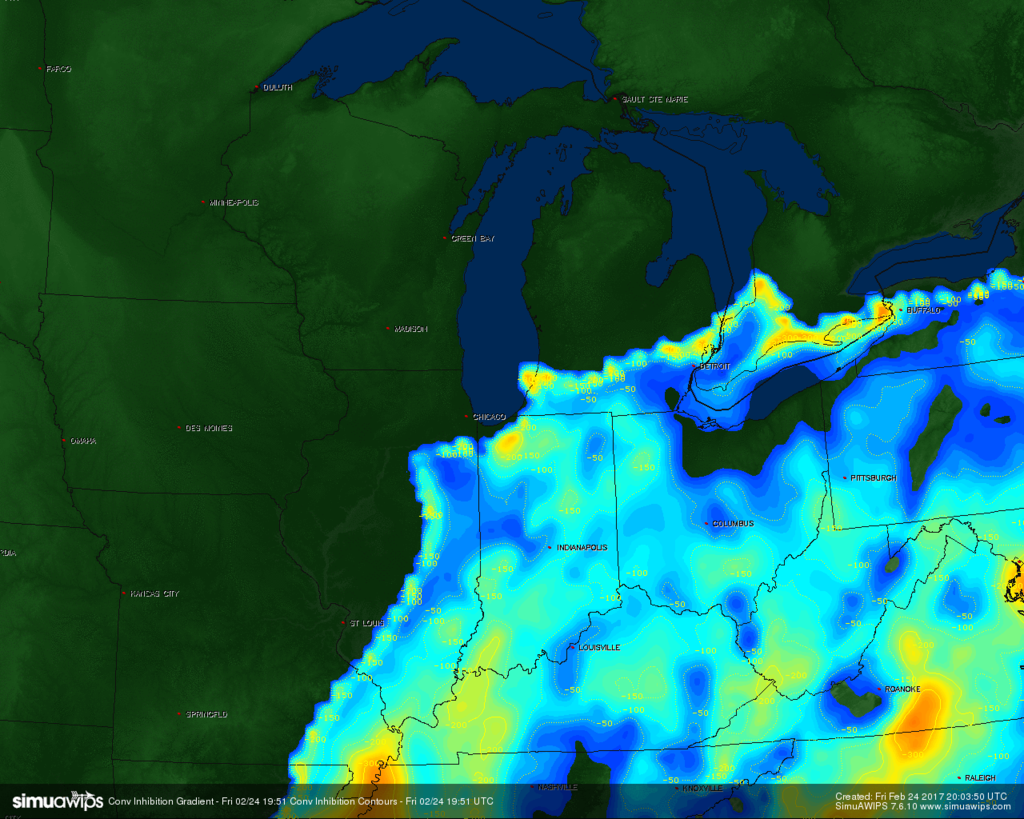
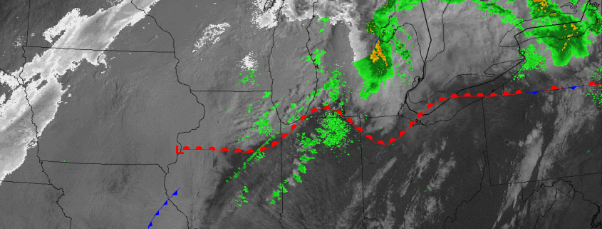
Current SIMUAWIPS analysis shows plenty of convective inhibition (CINH), preventing storms from taking full advantage of daytime heating.
We still do think that later this evening, when the storm system strengthens a bit and frontal forcing increases, we’ll get a decent low-level jet increase late this afternoon and through this evening, which may produce a strong to marginally severe line of storms along the cold front from eastern Indiana into Ohio. We still think Ohio may be more likely to see strong to severe winds since they are in the best location for an increase in the low-level jet. Some initially isolated discrete cells out ahead of the line may be able to produce some hail in Indiana and perhaps parts of Ohio, but the linear wind profiles indicate a transition to a line with moist mid-levels, so we do not expect many severe hail reports.
Additionally, the low-level jet is way too linear and weak right now to generate the necessary updraft helicity for tornadoes — which is why we never bought into a true tornado threat. There still may be some isolated tornado reports later this evening if some discrete cells can form ahead of the line of thunderstorms when the low-level jet does increase in strength. Fortunately, any tornado threat will be isolated and any tornado that does form should be weak.
Previous Content: During this early-spring…I mean late-winter day, the ingredients are beginning to come together for an impressive severe weather episode on Friday in the Ohio Valley. A strengthening storm system which will provide blizzard conditions for parts of the Northern Plains will have its warm sector line up perfectly with Gulf of Mexico moisture transport and instability. Furthermore, this strong storm system will be dragging a strong cold front to its east, helping to increase low-level moisture return via strong low-level winds from the Gulf of Mexico, provide plenty of lift via the frontal forcing, and also provide very cold mid-level temperatures. This is because behind the cold front, mid-level temperatures are very cold since there is actual winter-cold behind the front, but mid-level winds often blow so fast that they advect the mid-level cold air to places on the warm side/ahead of the cold front, helping to juxtapose a warm, moist airmass with cold air aloft and a lifting mechanism — perfect ingredients for thunderstorm formation. This cold air aloft and thus very strong thermodynamic and dynamic lifting with these types of systems this time of year often make up for not having a true summer-like low-level airmass and can provide lift equal to that of spring and summer-like outbreaks.
From here, the devil lies within the details as far as taking this severe weather episode from minor to major. At this point, we think this event will be somewhere in between. While the above details portend a significant outbreak, there are more nuances to this event, such as jet-streak behavior, as an alignment of strong jet streaks can turn lift from merely sufficient for thunderstorms, to majorly supportive. And what we see currently is a not ideal alignment of jet streaks in the low-levels and the upper-levels with when the storms actually initiate.