Long Range: Warmth on the way, but for how long?

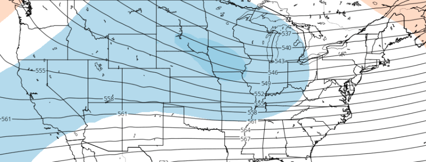
A happy Friday morning to you all! A large-scale pattern change is underway throughout much of the hemisphere — well, to be completely transparent, has been underway throughout much of the hemisphere — for the past few days. The seeds of the pattern change were planted long ago, almost 10 days before today, when a large ridge in the Eastern Pacific Ocean began to retrograde westwards towards the Aleutian Islands.

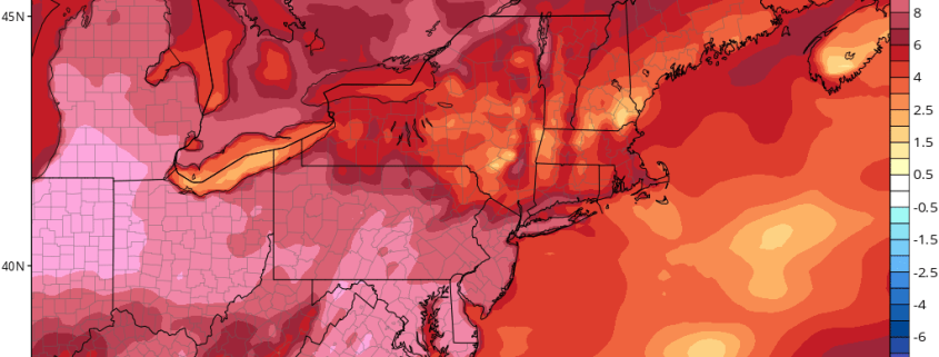
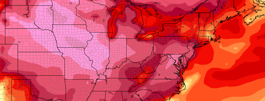
But even as recently as early this week, a ridge stood along the US West Coast, allowing northern stream energy (emanating from Canada and the arctic/polar regions) to drop southwards into the Northeast States. This ridge will finally collapse this week, dropping eastwards and flattening out. As it does so, arctic air over the Northeast states will be fleeting northeastwards into the Canadian Maritimes.

Read more

2.16 PM Zones: Warm, tranquil weather on the way

The news we have all been waiting for is drawing closer and closer! The warmup and tranquil weather, which we have been discussing for a few days now, is on the way this weekend. In fact, it will begin as early as Friday, when heights in the mid levels of the atmosphere will begin to rise. We still have a cold and blustery day to get through today — and a chance of snow showers with blustery winds will continue through the afternoon.

These will dissipate through the early evening hours and temperatures will remain quite cool tonight throughout the area. Lows are expected to drop from the upper teens through the 20’s in the entire region, with the warmest temperatures remaining near the coast and in the typically warmer urban areas such as New York City and Newark.

Read more

2/16 AM All Zones Update: Cold & Blustery Today…Warmer This Weekend

A strong closed low, which brought some heavy snow to parts of Northern New England, will support cold and blustery conditions. High temperatures will be in the middle to upper 30s. Northwest winds could gust to between 30mph to 40mph today. Skies will be partly sunny with highs in middle to upper 30s. Some instability and a weak upper-level disturbance will move through today. So some isolated snow showers or flurries can’t be ruled out, especially for the Interior.

Read more

PM All Zones: Squalls today as powerful system passes

As we move towards the halfway point of the workweek, a powerful northern stream disturbance will move through the region this afternoon. This disturbance began its journey to the Northeast US from the Northern Canadian/polar regions, and it is dropping very far south as a result of a disturbed arctic weather pattern and a strong ridge near the West Coast of the U.S.A. This disturbance will drop south and eastwards through New England tonight.

Most notably, perhaps, is the fact that this disturbance is missing a phase with a southern stream disturbance over the Mid Atlantic states, which would’ve forced the development of a much bigger and more powerful storm system. Nevertheless, its passage this afternoon and evening will lead to the the development of snow and rain showers.

Read more