-2")
Maria Finally Departs the Caribbean and Jose Fades. Whats Next?
Good Evening
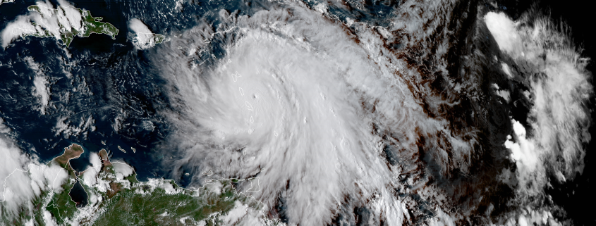
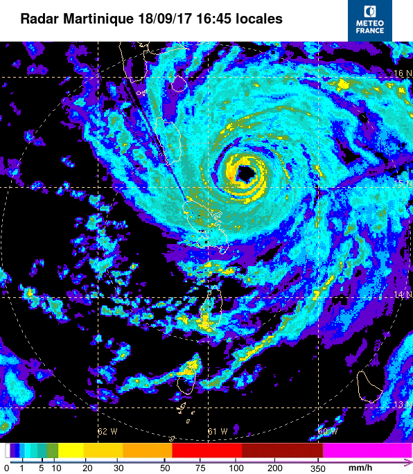
Back on Monday we highlighted the potential for Maria to become an extremely dangerous Category 4 or even 5 Hurricane before reaching the small island of Dominica in the Lesser Antilles, and unfortunately that is exactly what happened. Maria rapidly intensified into a Category 5 hurricane with 160 mph winds just before making landfall on the small island, and then preceded to head from SE to NW, leaving the entire island in its core for at least three hours. The storm was the second Category 5 land falling hurricane this season, tying the 2007 with Dean a Felix. Details are still very spotty, but the pictures, video, and first-hand accounts of Dominica are heart-breaking. Most, if not all of the homes on the island have suffered severe damage, with some houses being completely destroyed. Due to the topography of the island, devastating mud slides and land slides were common, which swept away homes, roads, and well-built concrete structures. Its hard to believe that we’d have a storm that would rival the total devastation that Hurricane Irma caused just a few weeks ago, but we could be looking at yet another situation where an entire island community has seen complete devastation. With the peak of the Cape Verde season quickly coming to a climatotlogical end, we should see the frequency of storms impacting this region begin to wind down, but I would not be surprised to see one or two more systems during the month of October given the active state that we are currently in.
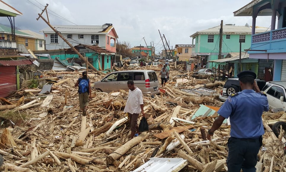
Damage from Hurricane Maria when it hit the island of Dominica as a Category 5 hurricane with winds of up to 160 miles per hour (Credit: The Guardian)
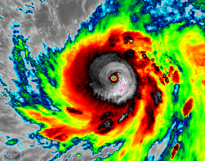
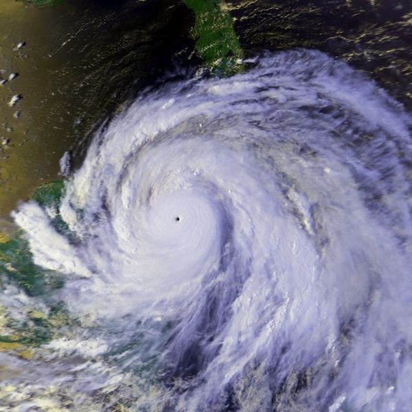
Due to the high, mountainous peak of Dominica and the amount of time that Maria spent traversing the island, the inner eyewall of the storm become disrupted and fractured, but not for long. On Tuesday the storm began to rapidly regain strength after dropping to a Category 4 hurricane. Recon missions throughout the day found that the storm had an incredibly compact eye of around 5-8 nautical miles and the winds rose from 155 mph to 175 mph during the course of the day, with the pressure falling to an incredible 908 millibars, making the storm the tenth strongest on record for the Atlantic basin.
Recon also released numerous dropsonde instruments which provide a vertical profile of various locations in the storm, and some of these probes happened to measure extreme winds of around 190-195 mph at the surface, but it is not certain whether these were instantaneous gusts or actually representative of the storms strength. Regardless, the storm began to approach the US Virgin islands late in the day on Tuesday and into the evening. Very deep convection began to develop quite rapidly around the center of the storm, and before long, concentric eye walls began to develop. This marked that the storm was about to attempt an eyewall replacement cycle before hitting Puerto Rico. It was clear that the storm would have issues completing this process and then intensifying once again due to the storms intensity and the size of the outer eyewall, but it also signaled for new dangers to arise. The storms wind field grew quite substantially as it approached Puerto Rico early Wednesday morning, causing the carious weather stations to be blown apart in addition to both weather radars on the island.
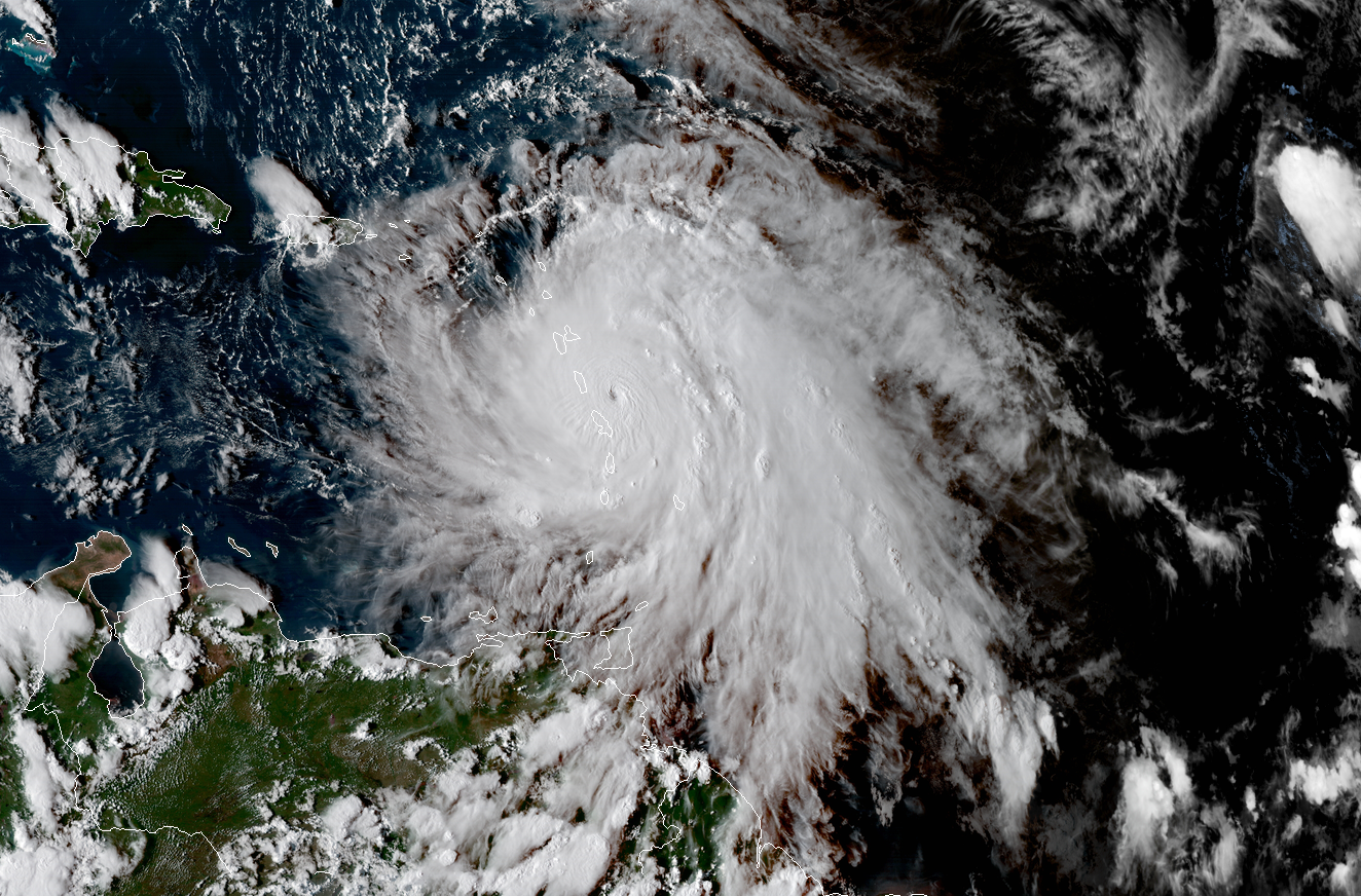
The storm raged ashore with winds in the 155 mph range, making Maria a strong Category 4 hurricane on the Saffir-Simpson scale. Maria went on to produce prolific flooding, wind damage, and cut a path of carnage across the island that would send all of its inhabitants into darkness as all of the power facilities went down during the storm. Details are also still rolling in slowly on the extent of the damage to the island, but it may be safe to say that the Puerto Rico that existed before Maria is no longer there. Estimates say that power may not be restored to some portions of the island for possibly up to 4-6 months. Additionally, much of the infrastructure will need to be rebuilt, which will be a daunting task in of itself. The next few weeks and months may be quite rough for the locals, but with resilience and endurance the people of the island will be able to overcome this disaster and restore their home to levels greater than before Maria.
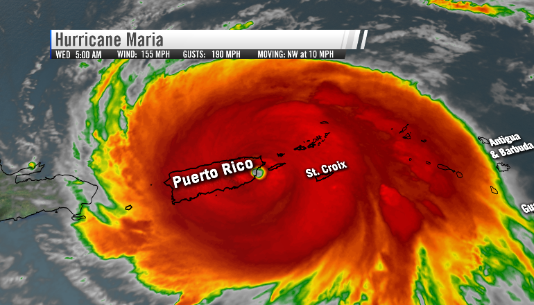
GOES 16 imagery of Hurricane Maria making landfall on the island of Puerto Rico with winds of up to 155 miles per hour
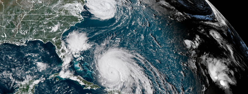
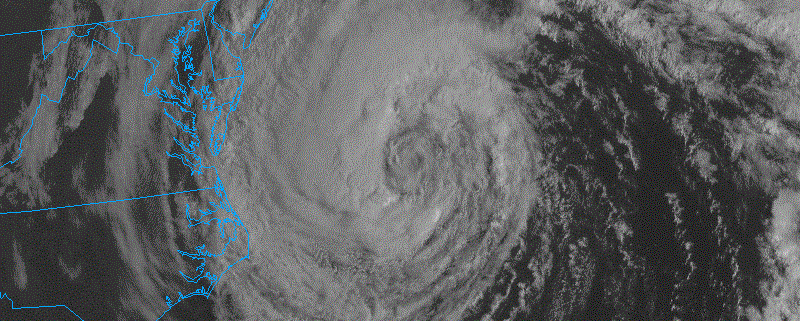
Maria has since left the Caribbean, and land interaction along with an increase in vertical wind shear have been affecting the system. The storm weakened down to a Category 2 on Thursday, but has since regained some strength and is now a 125 mph Category 3 hurricane. The storm is currently located very close to the Turks and Caicos, producing winds up to tropical storm force on the islands along with torrential rainfall as it slowly heads NNW at around nine miles per hour. Maria should keep this heading over the weekend and into the early portion of next week, but some key aspects of this forecast remain in question. While it is quite likely Maria misses the United States, the American model has been trending strong with the riding out ahead of Maria in the past few runs, bringing the storm precariously close to the Outer Banks of North Carolina. Again, such a solution looks unlikely right now, but with the remnants of Jose still meandering around, we truly will not know just how close the storm passes to the east coast before it makes its famed passage out to sea.
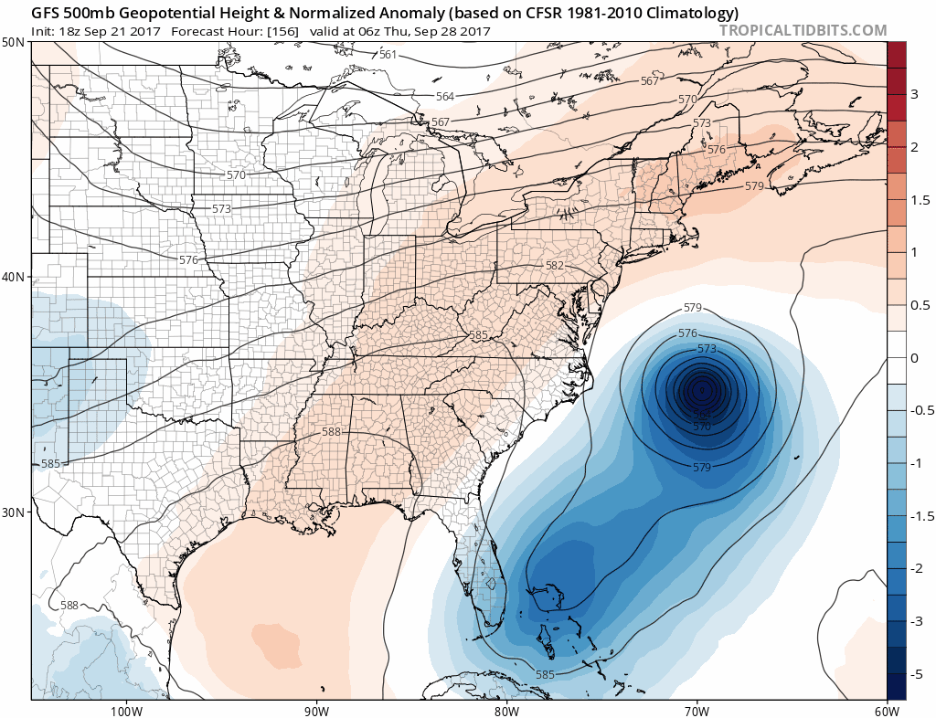
Trend loop of the GFS model showing the westward trend over the past 5 runs (Courtesy of TropicalTidbits)
So What Else?
Well, we have the remnants of tropical storm Jose which has finally become post-tropical after 70 advisories by the National Hurricane Center. For reference, this storm has been ongoing since Hurricane Irma was north of Hispaniola! The remnants of this storm should gradually dissipate over the next few days and really should not be much of a threat besides increased wave action and showers. Elsewhere, Tropical Storm Lee has come back to life after shedding about three different low level circulations over the past three days and is located well out in the open Atlantic, just east of a large upper level low. Lee is an extraordinarily small system and is reminiscent of Hurricane Michael from 2012 in that of it is relying heavily on baroclinic process to form convection and strengthen. Given its size and the upper level conditions, I would give the storm a higher than normal odds of becoming a small hurricane over the next few days.
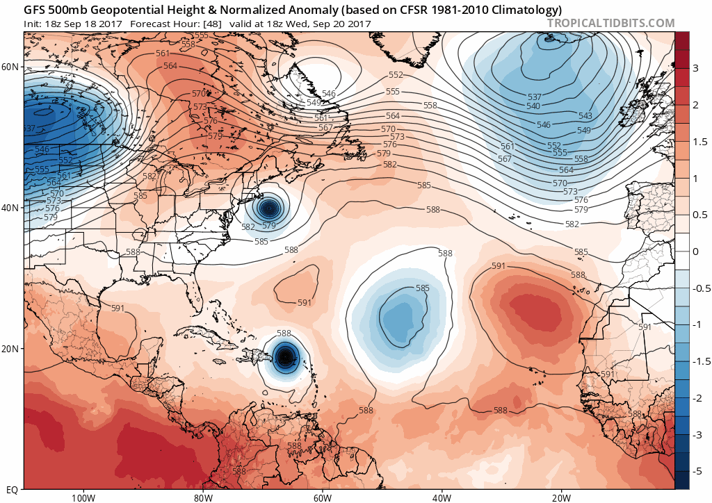
Lastly, our eyes turn to the western Caribbean as the month of September begins to fade. Medium and long range models are showing that this area of the Atlantic basin may become much more active during the next few weeks as a large area of upper level divergence sets up right over extremely warm sea surface temperatures of around 31-32 Celsius. This upper level divergence over very warm waters would promote a large amount of deep convection to form, which could eventually lower pressures in the Caribbean and cause a tropical system to form. This is all at least 8-12 days out at this point, but the signals are there that we should begin to monitor this region for potential tropical cyclone development as we near the beginning of October.
I will have a full update on Maria and any other threat that may pop up on Monday!
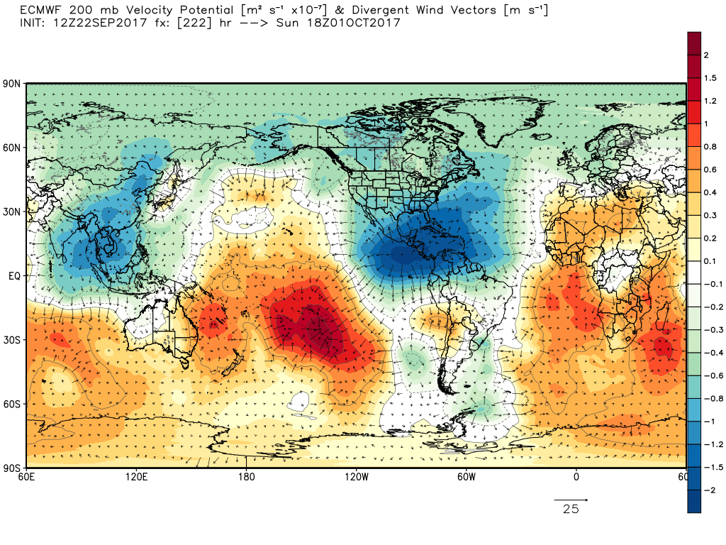
ECMWF model showing large scale rising over the western Caribbean in about 10 days. Conditions could become quite favorable for tropical cyclone genesis by this time.
Have an excellent weekend!
Steven Copertino