Public Analysis: Very Gusty Today, Close Call Thursday

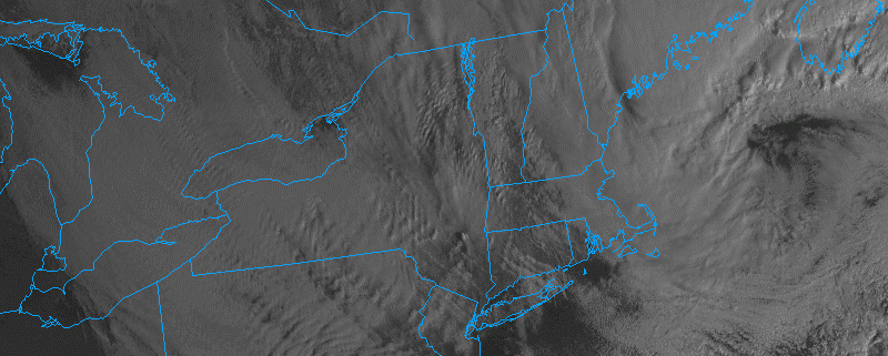
An area of low pressure which passed to our north on Sunday and provided our northern sections with some wintry precipitation is now located just to the east of the Gulf of Maine this afternoon. This area of low pressure has rapidly deepened into an impressive blizzard for parts of Maine bringing well over a foot of snow to some locations and can be seen clearly on today’s visible satellite imagery. This area of low pressure, in conjunction with a high pressure located over the Ohio Valley are producing a tight pressure gradient between the two systems which causes the air between them to accelerate rapidly and occasionally work their way down to the surface.

As of 1pm, the highest gusts in the immediate New York City area were White Plains, NY 72 MPH, LaGuardia 61 MPH, Stamford, CT 55 MPH, Glen Cove, NY 56 MPH, Central Park 44 MPH. These gusts should continue throughout much of the afternoon as instability increases and allows the winds above the surface to mix down from about 4,000-5000 feet above the surface. Winds of this magnitude will be able to easily blow garbage cans around, displace lawn decorations, break medium-large tree limbs, and possibly even cause localized power outages. These high winds have also prompted significant delays at local airports, with Newark experiencing over two and a half hour delays at this time. Accordingly, the National Weather Service has already issued wind advisories and high wind warnings through throughout the area.

Read more

AM All Zones Update: High Winds Today, More Tranquil Weather Tuesday

Today will have a mixture of sunshine and clouds, with temperatures remaining mostly in the 30s. But a storm that brought a wintry mix to parts of the region on Sunday, is currently intensifying rapidly east of New England. A tight pressure gradient behind this low has caused winds to gust between 40mph to 50mph already, in some locations early this morning.  Strong northwest winds will likely continue through at least early this afternoon, instability and mixing increases. These winds continue to be sustained between 20 to 30 mph with frequent wind gusts between 40mph to 50mph, through early this afternoon.

Read more

Late AM All Zones Update: Snow & Ice Continues For Some Areas This Afternoon

Low pressure currently over Western Pennsylvania will weaken, and as secondary low develops over Southern NJ/Delmarva. This storm system will try to push a warm front through the region. But it will likely stall south and west of NYC, as high pressure positioned over New Brunswick supports more cold-air damming with east-northeast winds over the region.

Read more

PM Zone Update: Multi-day winter weather in New England

A multi-day (and multi-disturbance) winter weather event will unfold across New England over the next few days, with central and northern parts of New England in line for several inches or more of snowfall. Multiple disturbances in the atmosphere will traverse from the Great Lakes and Ohio Valley into the Northeast, with coastal low pressure systems forming in multiple fashions. The first moves from our southwest on Saturday evening into Sunday morning, and has trend more significantly in terms of wintry precipitation. Much of this can be attributed to the snowpack in place across the interior — keeping low level cold temperatures locked in more effectively.

Warm air both in the mid levels and at the surface will be moving north from the Mid Atlantic states as Sunday morning approaches. But moisture and lift, effective in developing precipitation, will move northward as well, allowing wintry precipitation to break out across the region. Across Northeastern PA, Northern NJ, NYC and LI, precipitation may begin as snow and sleet – remaining a wintry mix for a few hours before a transition to rain occurs. The wintry mix will occur longer across the interior and higher elevations of NJ, SE NY, and CT where low level cold air will remain more stout. Here, freezing rain and sleet are possible for a more prolonged period of time.

Read more