Good Evening!
Yesterday we saw an extremely impressive Nor’easter impact much of the Northeast with heavy snow, highs winds, and extremely dangerous coastal flooding for the majority of the day. Snow totals varied quite a bit from west to east, but the highest totals for the region occurred from portions of eastern New Jersey, Long Island, Connecticut, and into New England, where amounts in the 10-20″ range were common. Totals over central and western New Jersey were lower, with numbers generally in the T-8″ range, as was common in PA and SNY. Overall, this was a very impressive and possibly historic storm due to its ferocity and sheer amount of power. Conditions came together in the atmosphere in just the right way to let this storm go from a rather weak 1010mb system off of Florida, to a monster 951mb blizzard off of the Delmarva coast. This extreme pressure drop contributed to the very strong winds we saw over the entire east coast and continue to see today and this evening.
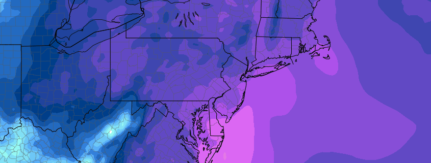
As the storm pulled away last night, a deep Arctic airmass dove down from northern Canada and has caused temperatures to once again drop into the lower to middle teens across much of the tri-state area. Much colder reading were seen over portions of New England, with some locations staying 10-12 degrees below zero! A strong pressure gradient will continue to exist between the Arctic area of high pressure over southern Canada and our blizzard that continues to move over portions of southeast Canada. Winds tonight will continue to gust into the 15-30 mph range and when coupled with lows in the only a few degrees above zero in the immediate NYC metro area, wind chills will become very dangerous. Wind chills will likely drop into the -15 to -25 range for NYC and the immediate north/west suburbs and -20 to -30 for locations in Southern New York and Northeastern PA. These kinds of readings can cause frostbite within 20-30 minutes of exposure, so please use caution if you must go outside late tonight and into the overnight hours and make sure to layer-up!
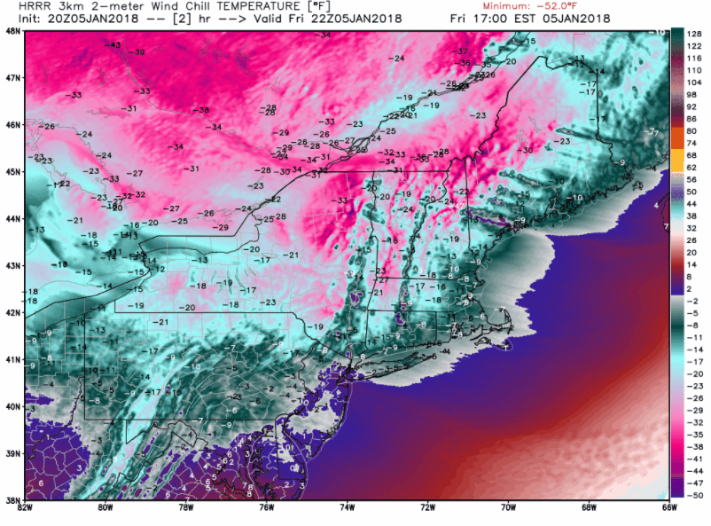
Animation showing the progression of tonight’s expected wind chills from the HRRR model. Readings will be at their lowest around 6-8am Saturday
This Weekend
Saturday looks to be yet another brutally cold and well-below normal day across the Northeast as Arctic high pressure builds into the region. Conditions should start off very cold and cool as mid-low level dry air takes over and limits any potential for any clouds besides upper-level cirrus. Winds may attempt to subside a bit during the day, but will likely still gust into the 20’s, which will still bring brutal wind chills in the -20 to -10 range during the early morning and afternoon hours. Highs across the NYC metro area will likely struggle to get out of the single-digits, with lower to middle teens expected to the south over portions of Pennsylvania and New Jersey. Frigid and dry conditions will last into the evening and overnight hours as we see lows drop off once again in the 5 to -10 range. Winds will continue to diminish, but wind chills will still be able to stay in the -10 to -20 range pretty much area-wide. Again, take the necessary precautions if you have to head outside tonight and Saturday night.
Sunday will be another cold and dry day across the Northeast as the Arctic high pressure system is directly overhead. Mid level dry air should ensure that conditions stay mostly sunny, with only a few passing high clouds expected. Despite the Arctic high being overhead, mid level flow will begin to modify ahead of a developing system in the Plains. This should cause temperatures to not be as brutally cold, with highs in the upper teens to middle 20’s expected across the entire area. Lows will likely not fall all that much as the high pressure system begins to exit off the Mid Atlantic coast and the entire region sees return flow from the south.
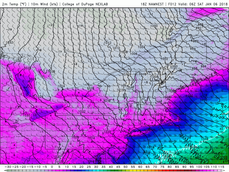
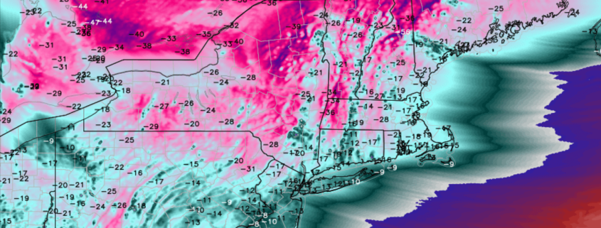
Animation showing the last of the brutal cold moving through the Northeast tonight and Saturday
Major Changes Likely By Next Week
After one of the most impressive and longest cold-spells in recent memory for the Northeast, one would think that things would eventually have to break down. Last week I asked this same question, but now it seems like the brutal cold will indeed gradually fade to relatively warmer conditions across the east. After the Arctic high pressure system exits the country by Sunday night, the upper level flow will become more east to west based, which is a strong departure from the highly amplified pattern we have been accustomed to over the previous 10 days. This pattern should allow for multiple shots of warmer air from the south and west to overtake the Northeast, with highs in the 30’s and 40’s likely to make a return. As of right now, there does seem to be a chance that we could get temperatures into the upper 40’s and possibly lower 50’s, but this is around a week away and will likely need to be revisited next week. Regardless, while we may see slightly above-normal temperatures at times, we do have to keep in mind that this is still January and the potential for snow will always remain present. Would could see a rather active period with above normal precipitation through the middle of January as deep tropical moisture may occasionally try to nose its way into the country. We will be watching this potentially warmer and wet period closely over the next couple of days and will provide updates when they are available!
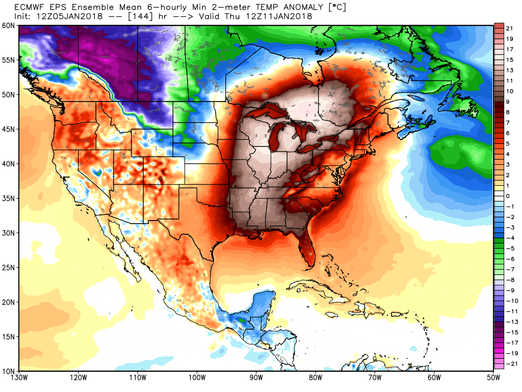
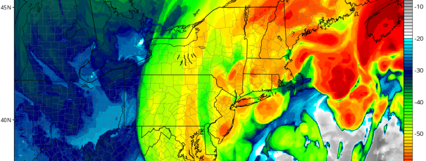
This afternoons ECMWF ensembles showing the potential for above-normal temperatures next week across the central and eastern US
Have a great weekend!
-Steve Copertino
-2")