-2")
Wide Variety of Impacts Likely From Weekend Storm, Warmer Weather On Borrowed Time
Good evening!
Today has been another in a series of relatively warm days when compared to the sub-freezing ice-box that the Northeast was stuck in over the past two week. High pressure has been moving off the coast throughout the day today, leaving most of the Northeast with southeasterly winds at the surface which helped to bring in slightly above-normal temperatures for this time of year. Highs were able to reach into the upper 30’s to middle 40’s across much of the NYC metro area this afternoon, with middle to upper 30’s over much of the Lower Hudson Valley. Today started off rather clear, but westerly winds in the mid levels of the atmosphere allowed for some weak mid level energy to pass over the Northeast. This weak mid level energy helped to bring some increasing mid level clouds this afternoon, which likely capped off our high temperatures for the day. As we head later into the evening and the overnight hours tonight, this mid level energy is expected to clear out as the area of high pressure centered off the Mid Atlantic coast begins to head off to sea. This will allow for mid level flow to strengthen from the south and west, which should bring in increasingly warmer mid level temperatures this evening. We may see the early evening temps become our overnight lows as most of the I-95 corridor may warm up a few degrees during the overnight hours. Regardless, lows will likely be in the lower to middle 30’s across the Lower Hudson Valley, with locations in and south of NYC likely getting into the middle to upper 30’s. It may not be all that impossible to see some locations in central and southern New Jersey to see temperatures rise into the 40’s during the overnight hours.
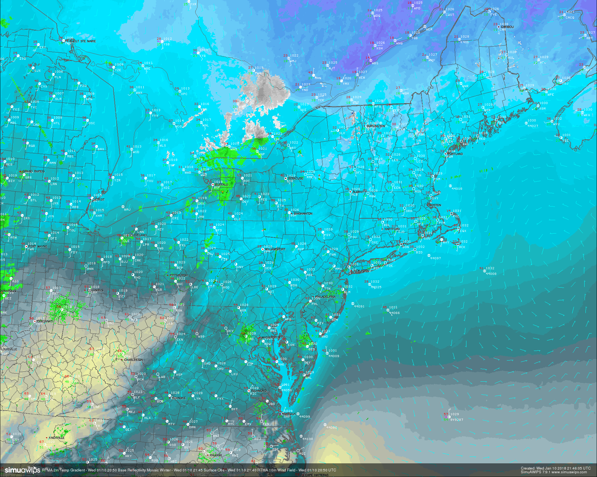
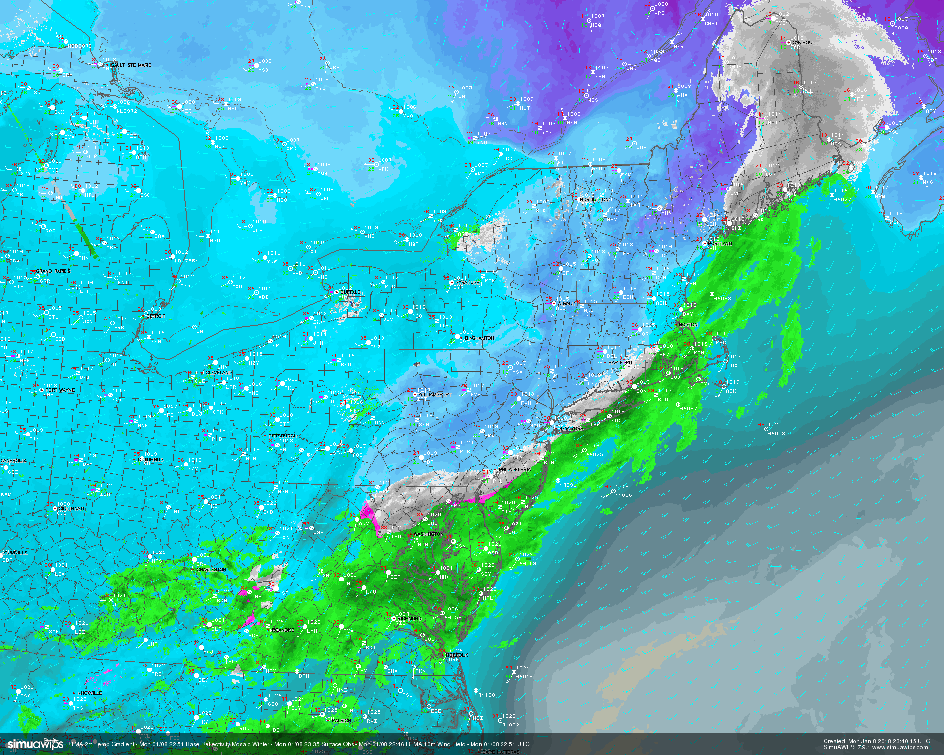
This evenings surface observations, RTMA 2 meter temperatures, and regional radar mosaic showing a rather dreary and cool day across the Northeast with warmer temperatures off to the west
Thursday is likely to start off rather cloudy and cool as winds from the Atlantic continue to bring in a moderately moist airmass in the mid levels. These clouds and even some spots of patchy drizzle will likely continue throughout the majority of the day as a large system centered in the plains continues to drag a more moist/warm airmass over the Mid Atlantic and Northeastern States. Widespread cloudiness through the lower to upper levels should allow highs to rise into the upper 40’s to lower 50’s across much of the area tomorrow, with some locations to the south of NYC likely getting into the lower 50’s. Very strong southerly flow should become well established by the evening and overnight hours, and we may once again see temperatures rise a bit into the upper 40’s and lower 50’s. Moisture content in the atmosphere will also begin to rise rather rapidly ahead of a frontal system over the Ohio Valley, which may begin to kick off some light to moderate rain showers over much of the Mid Atlantic and Northeast.
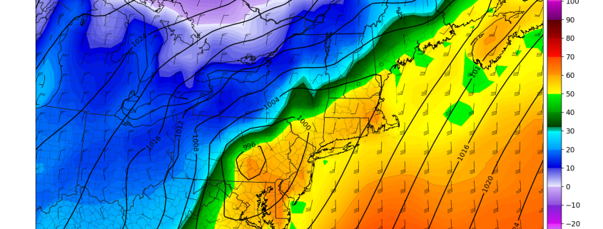
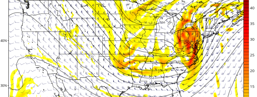
Friday morning will almost certainly start off very warm and cloudy, with the threat for some steady rain, especially as you head further west into western NJ and PA. As the front gets closer to the Northeast during the afternoon hours, there will be much more available lift in the atmosphere to support more moderate to heavy rain. Moisture content will also be very high (PWATS around 1.4″) for this time of year, so some of the heavier areas of rain may be capable of very heavy downpours that may cause some street flooding. This flooding threat will also be exacerbated by the amount of snow left over the area, with the greatest risk for street flooding in more urban locations with poor drainage. Some of the higher resolution models are also indicating the potential for some thunderstorms to exist, as some very marginal instability looks to be in place around 11am-2pm. Steady rain is likely for the remainder of the day, with the heaviest rain likely occurring over portions of eastern NJ, LI, and CT. Temperatures will be very warm on Friday, with highs likely reaching well into the upper 50’s! This will further help to melt any leftover snow, which will compound any potential flash flooding.
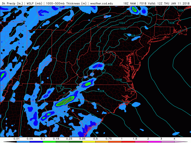
This afternoons NAM model showing the potential for periods of very heavy rainfall over the East on Friday and Saturday
Myriad of Impacts Likely on Saturday
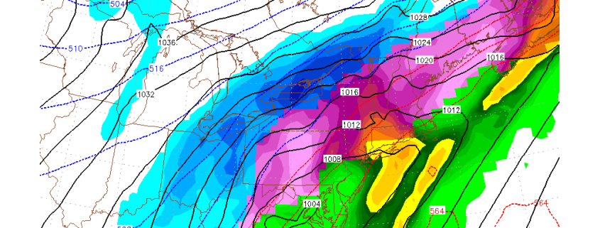
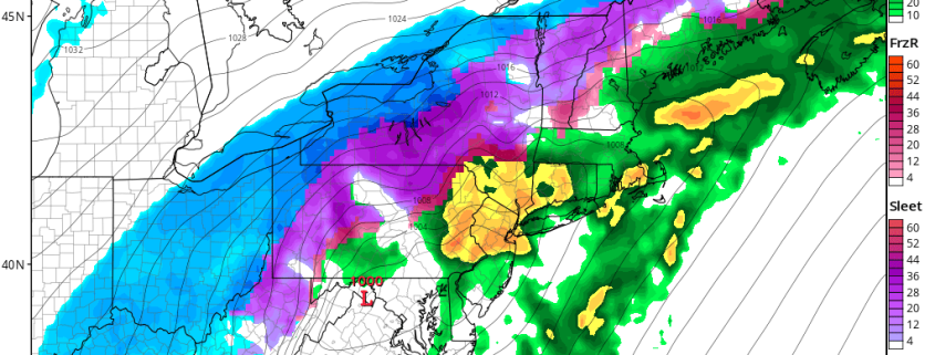
Low pressure will be tracking from the Tennessee valley and into the Mid Atlantic states on Friday evening and into the overnight hours as a large Arctic high pressure system extends from the northern Plain and into portions of southeast Canada. By early Saturday morning the low will likely be located over the Mid Atlantic states, with a large area of moderate to heavy precipitation over the Northeast. This part of the forecast becomes tricky, as some of our more reliable models have been trending weaker and further southeast with this area of low pressure on Saturday. This is very important detail to nail-down in the 24 hours, as the Arctic high pressure extension will be capable of bleeding sub-freezing air into the Northeast, and this could lead to a significant amount of Saturdays precipitation being frozen for portions of New England and potentially locations further south.
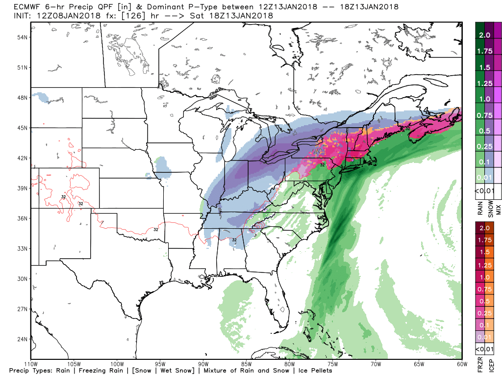
If this system is weaker and further south and east, we may see heavy rain over NJ, LI, CT, and eastern New England, with heavy snow over portions of PA, upstate NY and VT/NH. This afternoons European model showed a similar scenario, but with a significant amount of freezing rain and sleet over portions of PA/NJ, extending all the way north and east into Maine. This type of scenario certainly seems possible at the moment, and we may see the NWS issue Winter Weather Advisories or even Winter Storm Warnings in the next 24-36 hours over portions of the Northeast if this trend continues in tonight’s model runs. Computer models often have a tendency to under-model cold air in the low levels of the atmosphere, which is why we are suggesting that you keep a very close eye on the NWS over the next couple of days, as this would be a potentially dangerous situation for portions of the Northeast. Regardless, more heavy rain would be likely on the eastern side of this low, with the brunt of the rain falling once again over eastern NJ, Long Island, and Connecticut. Rainfall totals in that area may reach amounts of 3″ to locally 5″ in some spots, with a general 1-3″ likely for the rest of the region.
Another hazard we must mention will be the potential for a “Flash Freeze” on Saturday as the Arctic front moves through the Northeast. Temps will quite rapidly fall from the middle to upper 50’s in the early morning hours of Saturday, to below-freezing Saturday night. Any residual rain on roadways will freeze quite quickly and could lead to very slippery conditions, with some spots of black ice. This threat does seem more likely as this time, as the Arctic front is almost a guarantee to quickly move from west to east on Saturday. However, we will be very closely monitoring this potentially dangerous storm over the next few days and will continue to provide updates!
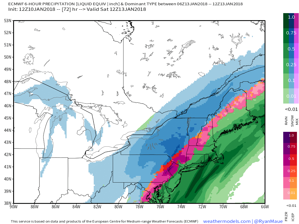
This afternoons European model showing a very wide range of impacts on Saturday with the potential for heavy snow, ice, and potentially flooding rains over the Northeast.
Have a great night!
Steve Copertino