Morning Snow Winds Down This Afternoon

Good morning! An inverted trough extending from low pressure offshore has resulted in bands of snow and rain across parts of the Northeast to start the day.  The majority of steady snow so far today has been situated over parts of Northern NJ and the Lower Hudson Valley into Southern New England, where the airmass remains colder and more supportive of precipitation. Closer to the coast, enough warm air from east-southeast winds off the ocean has lead to mainly light rain with some snow mixing in at times.

As low pressure moves further east off the Northeast coast and begins to deepen, it will drag colder air in behind it via northerly winds. Precipitation may end as a period of snow for coastal areas with some light accumulations under 2″. In fact, this is occurring already as of 8am over much of the NYC Metro Area. Any accumulations will likely be relegated to colder surfaces as temperatures remain above freezing.

Read more

Snowstorm expected tonight across interior Northeast, less near coast

In the middle of a winter that seems to continually overproduce at the final buzzer comes another storm system, expected to develop late tonight into early Wednesday morning, that is expected to bring moderate snowfall to much of the Northeast states. It is really quite remarkable how many storm systems have trended more wintry in the final moments during the first half of this meteorological winter, and this storms system will be no exception. Occurring during a pattern transition, with warmer air moving in to the Northeast, it will feature challenges in terms of precipitation type.

A weak low pressure system is already in the process of developing off the Southeast US coast this morning. This low pressure area is mainly associated with an offshore baroclinic zone, or temperature gradient, near the Outer Banks of the Carolinas. Increased precipitable water values are noted on observations and forecast soundings, and models suggest this low pressure area will gradually organize later today.

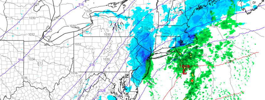
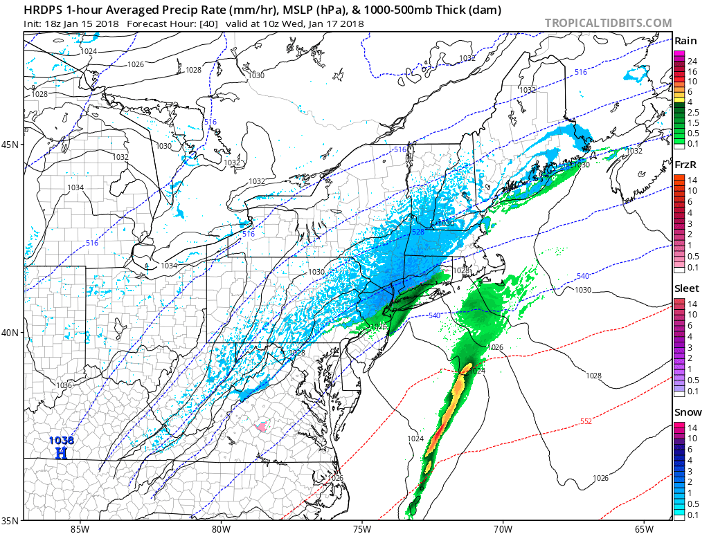
Meanwhile, a deep trough will dig over the Central United States and is expected to amplify through the Mississippi Valley. As it turns towards the coast, and vorticity advection occurs near the coast, lift in the atmosphere will increase along the baroclinic zone and the low pressure system will deepen while heading north/northeastwards towards the Long Island coast. Precipitation is expected to develop to the west of the low pressure, near a frontal boundary, across the Northeast states later tonight.

Upper-level trough digging and amplifying over Eastern US. But the trough remains positively-tilted and more progressive.

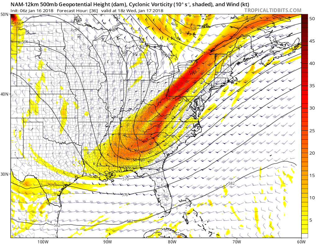
The deep trough amplifying over the  Eastern US. But the trough remains positively-tilted, resulting in a more progressive storm system on Wednesday

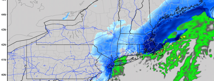
Initial precipitation will be light, but steady, across parts of Pennsylvania and New England. But as the storm system gains some steam, banding is expected to develop across parts of New Jersey, Southeast New York and Connecticut and spread into New England. Without any prevalent high latitude blocking, the system will remain mostly progressive. But wintry precipitation amounts could still be significant in some areas, particularly across the interior.

One of the biggest forecast challenges tonight will be temperatures. While plenty of cold air exists aloft, forecast models are consistent in suggesting that the boundary layer will remain quite warm. The boundary layer is the low level atmospheric profile — where we live. And if it is warm enough, snowflakes can melt before they reach the ground. With an onshore flow (wind off the water) prior to the storm, models suggest this will be the case for much of Eastern New Jersey, Long Island, and Southeast Connecticut — mostly a cold rain.

Just inland, however, bands of snow are expected later tonight, and the potential exists for several inches of snow. While quick moving, models suggest enough dynamics for moderate snow in these bands, with quick accumulations of 3-6″ and possibly amounts higher than that in the highest elevations of Northwest NJ, Northeast PA, Southeast NY and New England. The winter storm is expected to be moderate impact in these locations, with a lighter impact event in NYC and even lighter along the coastal plain.

Expected Storm Total Snowfall from Tuesday Night/ Wednesday Afternoon

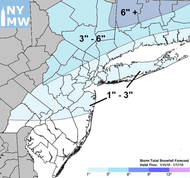
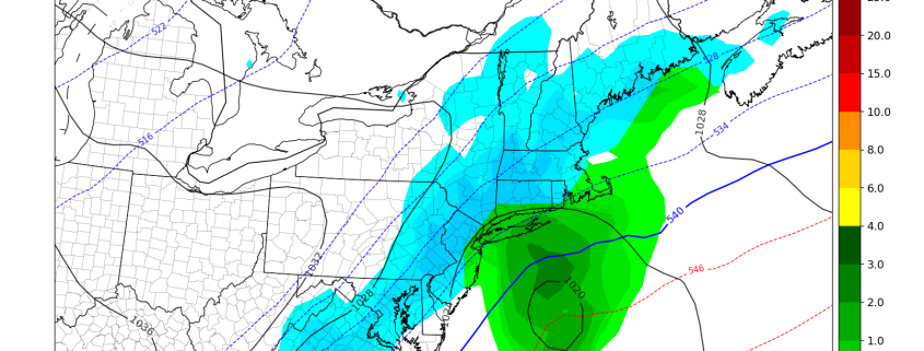
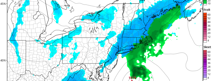
Expected Storm Total Snowfall from tonight through Wednesday Afternoon

The National Weather Service has, accordingly, issued Winter Weather Advisories for many locations. These create a good visual as to where the impacts are most likely and expected. In these regions, plan for winter weather tonight, including 3-6″ of snowfall, and leave extra time for travel through Wednesday morning when the event finally comes to a close.

The good news? Much warmer weather is anticipated over the coming days, with temperatures 10-15 degrees above average by this weekend! More details to come on that — we have a snowstorm to get through first.

Light to Moderate Snow Likely Tuesday Into Wednesday

Good evening! 

Most of the Northeast saw another below-average day as the Arctic high pressure system that has been dominating our weather over the past few days has finally begun to head off to the east over portions of southern Canada. As this high pressure system retreated to the east, we saw wind direction flip to a more easterly/northeasterly, with winds in the mid levels becoming more southwesterly ahead of a large disturbance moving south over the Great Lakes region. These southwesterly winds have aided in providing a slightly warmer airmass aloft, with some weak moisture also working into the low to middle levels of the atmosphere. This allowed the development of some mid to upper level clouds over the Mid Atlantic and Northeast during the afternoon hours, with even some scattered flurries being reported within in a weak band of moisture over portions of Pennsylvania. The combination of slightly warmer mid levels, partly cloudy conditions, and easterly low level flow made for slightly warmer highs when comparing them to the past two days. The immediate NYC metro area saw readings in the upper 20’s to lower 30’s, with locations to the north and wets seeing temperatures in the lower to middle 20’s, which is still around five or so degrees below normal. Generally dry and calm conditions are expected for the rest of the evening and into the overnight hours, with a slight chance of some widely scattered flurries. Temperatures will likely fall back into the lower to middle 20’s across the immediate NYC metro area, with teens expected to the north and west.

This evenings latest look at the regional radar mosaic, surface observations, and RTMA 2m Temperatures, showing a rather chilly evening with a disturbance approach from the west

This evenings latest look at the regional radar mosaic, surface observations, and RTMA 2m Temperatures, showing a rather chilly evening with a disturbance approach from the west

Light-Moderate Snow Event Likely Tuesday Into Wednesday 

This afternoons model guidance has come into slightly better agreement regarding a large closed upper level low centered over the Great Lakes region this evening. This upper level low has been meandering in about the same position for the past 36 hours or so, but this will change tomorrow afternoon as an impressive Pacific disturbance crashes into the West coast. This disturbance will act as a “kicker” for the upper level low in the Great Lakes, and cause it to elongate while becoming positively tilted. As it does so, a large upper level jet will extend from the Southeast Unites States and into the Northeast.  Some weak moisture will be involved in this initial setup, allowing for snow to break out just ahead of a frontal system as the upper level jet provides some adequate lift along the front. This frontal system will be located over the eastern third of the country by tomorrow afternoon, with snow likely forming over much of the Mid Atlantic and Northeast during the late morning and early afternoon hours. Some light snow may work its way into the NYC metro area later in the afternoon, but there may be some rain mixed in closer to the coast as surface temperatures hover at or above freezing.

Simulated Radar showing a potential evolution of the snow event on Tuesday/Wednesday

Simulated Radar showing a potential evolution of the snow event on Tuesday/Wednesday

A weak surface front associated with some more robust moisture from the Atlantic will begin to develop off the Mid Atlantic coast during the late afternoon hours and into the evening on Tuesday. This afternoons models have shown more of the moisture becoming super-imposed with the upper level jet streak aloft, which allows a very weak coastal low to develop off of the Delmarva peninsula by 8-10pm tomorrow night. Depending on the track of this low and the associated moisture plume, we could see more moderate snow develop over eastern PA, MD, VA, SNY, eastern NJ and Connecticut during the overnight hours. Again, precip type may be more wet than white closer to the coast, but we could see a gradual shift to snow during the morning commute for locations to the south and east of NYC. This weak low pressure system will be moving at pretty good clip, so as of now we expect that snow will peak in intensity over the NYC area right around 7-9am before very gradually tapering off from west to east during the afternoon. At this time, we expect generally light accumulations to the south of Northern NJ, with light to moderate accumulations further off to the north and east.

There are some uncertainties that remain with this system, as surface temperatures during the height of the storm may be a little too warm for accumulating snow, and this would cause totals to decrease a bit, especially to the south. Another possibility is that we see the coastal low develop a little quicker than originally thought, which would not only brings in more moisture, but would drag more cold air in from the north. Such a solution would yield higher snow amounts area-wide, but at this time we feel that solution is less likely to happen. However, we will be closely monitoring this system over the next day or so, so make sure to check back for future updates!

Expected Storm Total Snowfall from Tuesday Night/ Wednesday Afternoon

Expected Storm Total Snowfall from Tuesday Night/ Wednesday Afternoon

Have a great night!


Steven Copertino 

Some Snow Likely in the Northeast Tuesday & Wednesday

Good morning! Very cold temperatures are again starting this week. A mixture of sunshine and clouds are expected for today. Highs will be in the mid-upper 20s. Cold and dry conditions will continue into tonight. But clouds will be increasing, as the next storm system approaches the Northeast. Temperatures will near steady for most of the night.

A large positively-tilted trough will begin moving into the Eastern US on Tuesday. A clipper low associated with northern stream shortwave energy along this trough will drag a cold front into the Northeast and Mid-Atlantic region tomorrow. Moisture will be initially limited with this system overall. But some bands of light snow will be developing, over the Interior areas morning and midday hours. Then these bands will be moving into the coastal areas during mid-late afternoon or early evening hours.

Read more