Severe thunderstorms likely in the Northeast on Tuesday

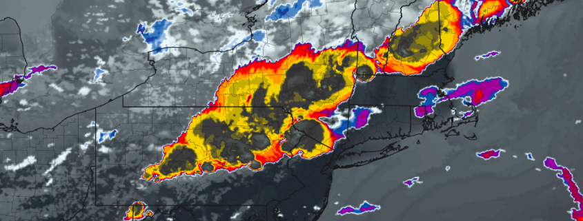
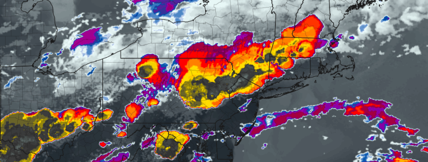
Good evening! After beautiful second half of the day in the Northeast states on Monday, the atmosphere has already begun to become more unstable as southwesterly winds begin to usher in a warmer and more unstable airmass. Forecast models are in good agreement that on Tuesday, a shortwave disturbance traversing the Northeast states will interact with an unstable airmass and trigger the development of severe thunderstorms. These storms will have the potential to become severe, and given the wind shear in place the threat for strong winds could be widespread.

Below, we have detailed the threat in a Severe Weather Briefing, which includes our own forecast maps and ideas as well as expected risks, timing, and preparation steps. We remind you that official forecasts for severe thunderstorms come from the Storm Prediction Center. Check out our briefing below for the very latest information on the threat for severe weather on Tuesday.

Read more

Weekly Briefing: Severe weather possible Tuesday, warm weather ahead

Good morning and Happy Monday! Welcome to our Weekly Briefing, where we break down the Northeast US weather pattern in a detailed and easy to understand forecast. If you were outside at all this weekend, you probably noticed the rain and cool temperatures. You can thank a “wedge” of colder temperatures for that. Cool air was funneled into the Northeast US for the majority of the weekend by northeast winds (it was damp as well).

After a few disturbances passed by on Sunday evening and into the overnight hours, things have begun clearing out this morning, and are expected to continue to do so throughout the majority of the day today. All in all, Monday is expected to be a fairly pleasant day. Temperatures will be nearly 20 degrees warmer than they were on Sunday, rising well into the 70’s across a large majority of the Mid-Atlantic and Northeast states. Temperatures will remain quite warm this evening, and the airmass that builds into the area through tonight will mark the approach of a warmer and unstable airmass which will set the stage for an active weather day on Tuesday.

Read more

Two Week Warning

<– Back to Gravel & Grace

You know that tingly feeling you get when you’re about to start something really exciting? Like right before a big sports game, or directly before a surprise party, or when you see the waiter walking toward your table with food? Today is a little bit like that.

In all seriousness, the excitement is starting to build. We’re exactly two weeks away from the start of our storm chasing adventure, which will begin in Minneapolis, Minnesota on May 25th, 2018. We fly in to Minneapolis in the early morning directly out of Kennedy Airport in New York City. It’s going to be a really exciting day. I’ll be bringing along a super-awesome chase partner for this storm chasing trip (it will be her first). You’ll find out more about her later.

Read more

Severe T-Storm Threat Today, Unsettled Weather This Weekend

Good afternoon! After a some beautiful weather early this week, a more active pattern with some unsettled weather is coming for over the next several days or so. In fact, a much wetter pattern may be developing for the weekend and early next week. We will discuss more details, on this may happen below.

Read more