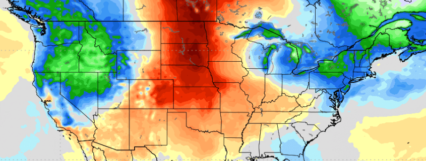
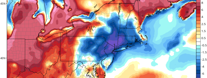
Heat Builds in the Plains, Cooler Weather Persists in the Northeast

While it’s been very warm and muggy at times, during the May and into beginning of this month, more periods of some cooler and some wetter weather have domnated over the Northeast US. Unfortunately, we don’t expect this general theme to be changing very much over next week or two. In fact, this summer isn’t looking to be very hot one for Northeast, based on our summer forecast research into analog years that feature similar pattern for the Spring months, (March to May) and current trends with a more neutral ENSO. But there might a be few changes for awhile during the middle to later part of this month.

Read more

Warmer Today, Then Cooler & Unsettled Weather Returns

Happy Tuesday! Today will be much warmer and more humid than yesterday. More upper-level ridging with subsidence builds into Northeast today. This will cause low clouds again this morning, to clear for more sunshine by the afternoon hours. Southwest winds will also help temperatures rise well into the 80s across the region. Along the south-facing shores, sea-breezes will keep temperatures in the 70s.

Read more

Day 2: Chasing Reverie

Okay, lets just start by saying this about yesterday: WHAT A DAY! After much deliberation and thought, we made the decision to chase in Southeastern Wyoming. There were many factors (logistics, landscape, meteorology, etc) but we were comfortable with our decision throughout the majority of the day. Until an isolated supercell formed in Colorado and produced a wall cloud. I would be lying if I said I didn’t consider shooting south to catch this discrete storm.

In chaser lore, this would have been known as the “decoy storm”. And it was. The updraft that had been rooted near an upslope boundary in Wyoming began to strengthen again as inflow into the storm system increased. We positioned ourselves just to the east/southeast of the storm and began observing increasing rotation. Just around that time, the storm itself separated from the upslope and began shifting east – it was now on its own.

Read more

First Chase Day

<— Back to Gravel & Grace 

It really does feel like Christmas morning! The first chase day of 2018 is upon us. We’re in Nebraska, heading westward towards the Nebraska Panhandle later this morning. Forecast models are in good agreement on the overall setup later today, but the setup itself presents a tremendous amount of complications and subtleties (when does it not?) that will make it a very difficult chase. The first chase usually is the toughest and today does not look to be any different.

The synoptics of the setup features favorable moisture return into the upslope regions of Colorado and Wyoming with favorably positioned instability developing amid a swath of notable mid level winds. This mid level wind maxima shifts eastward into Colorado later today with 500hPa wind speeds exceeding 55kts by 21z. The NAM and HRRR as well as other convective allowing models are in good agreement on this.

Read more