-2")
Slightly Cooler Temperatures This Week, But The Same General Pattern Remains
We have had a stagnant warm and very humid weather pattern over the past couple of weeks, and that general theme is expected to continue. The chance for a scattered afternoon thunderstorm each day also exists, with perhaps a bit more of a widespread threat on Wednesday or Thursday, depending on the timing of an impulse traversing the northern tier of the country. Then, for next week, bigger heat moves back in with perhaps the hottest temperatures of the summer.
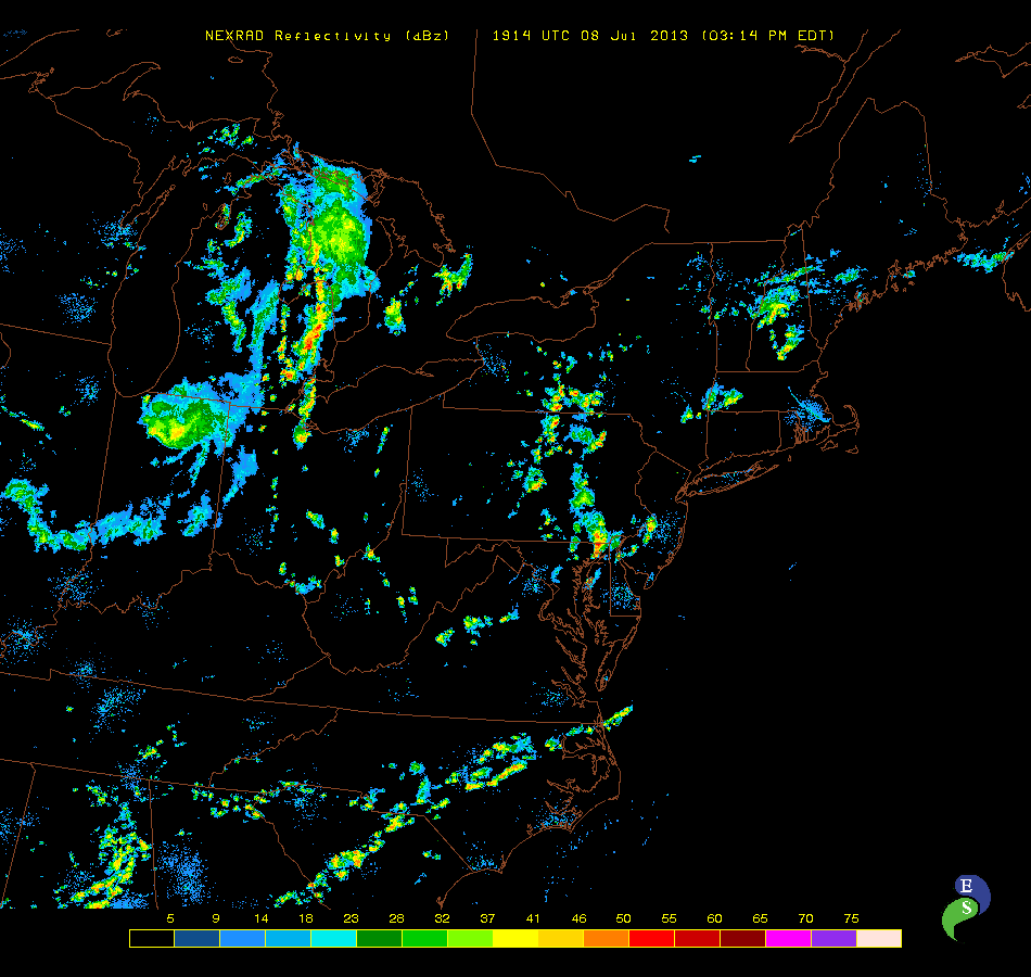
Radar as of 3:15 p.m. EDT (today) shows storms developing to our west due to daytime heating. Some will try to move towards NYC later this afternoon, but they should not be severe and may weaken as they do so.
Today, we still have a weak shortwave in our area, but it’s a bit weaker than it was yesterday, so our shear is a bit weaker for thunderstorms. Also, the Western Atlantic Ridge has pushed back to the east a bit, which helps to shunt some of the warmest temperatures back to the east. Thus, temperatures today and throughout the week should be several degrees cooler than they were yesterday. Still, though, warm and humid conditions will prevail — with temperatures in the mid to upper 80s throughout the week.
As the shortwave moves east and daytime heating continues, thunderstorm coverage should increase. Since shear and mid-level winds are low, the storms will mainly be pulse severe in nature and slow-moving. Steep low-level lapse rates and high moisture make strong winds and heavy rain the main threats. A widespread severe weather threat is not expected, however.
For Tuesday, the shortwave will move out to sea, with weak height rises behind it, thus limiting any lifting mechanisms for thunderstorms. We do not expect much in the way of thunderstorm activity for the local area tomorrow. A strong shortwave north of the Great Lakes will become embedded within a longwave trough, perhaps leading to an MCS spreading eastward into western PA. Perhaps E PA and W NJ could get indirectly affected by this towards the evening.
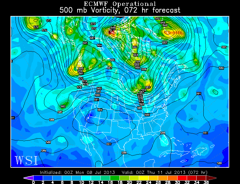
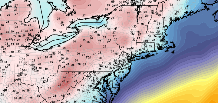
The European Operational Model shows a storm system north of the Great Lakes, combining with the Western Atlantic Ridge to usher in quite warm and humid conditions for Wednesday, with the chance of afternoon thunderstorms. The best threat, as of now, will be north and west of NYC. Image courtesy of the WSI Model Lab.
For Wednesday, that strong disturbance will continue to move eastward, creating stronger lifting mechanisms for thunderstorms over a more widespread area in the northeast. However, the disturbance appears to be a bit too far northwest during peak heating for the main thunderstorm threat to be over our area. The storm’s trailing warm front will probably be located in Northern New England, so the strongest mid-level flow and lifting mechanisms will be to our north. SE Upstate NY could be affected, however, and more isolated storms could press towards our area; especially considering that instability should be pretty high. Regardless, the probability of unsettled afternoon weather is a bit higher on Wednesday than the previous days. Out ahead of that disturbance, stronger SW flow will be ushered in from the Gulf, and the Western Atlantic Ridge temporarily pushes back to the west, creating the hottest and most humid day of the week. Temperatures should surge to the low 90s.
For Thursday and the weekend, there is a tad bit of uncertainty. The cold front to the south of the warm front will move eastward, but then get halted a bit due to the ridge to the east. The close proximity of the front will allow for more cloud cover and cooler temperatures than on Wednesday, with temperatures sliding back into the mid to upper 80s. The chance for rain and thunderstorms may be a bit higher on Thursday than on Wednesday, but severe potential seems low for now. The exact position of where the front gets held us will affect how much rain we see — once the front gets east of us, temperatures should cool off even more, humidity would drop a bit, and the rain threat could lower significantly for Friday and the weekend.
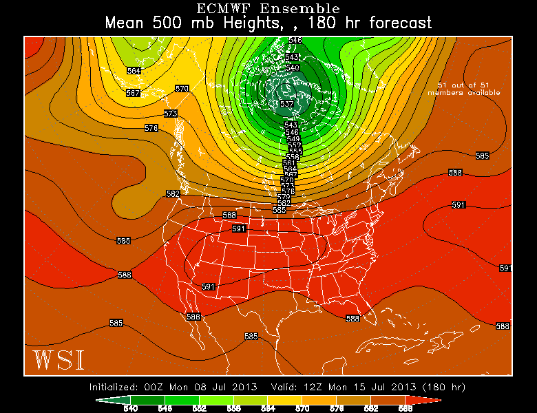
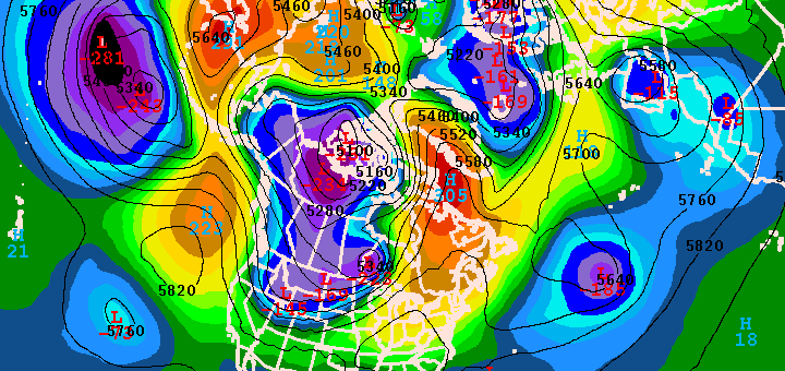
European Ensemble Mean data shows a strong heat dome building into the Midwest, along with the strong Western Atlantic Ridge building back in. This should help to create another heatwave for next week. Image courtesy of the WSI Model Lab.
For next week, we may have to watch for more widespread heat to work its way back into the area again, similar to last week and this past weekend — only perhaps a tad warmer. Lots of medium range model guidance is showing the Western Atlantic Ridge building back even further west, which would help to usher in more heat and humidity from the Gulf. Additionally, the heat dome that previously gave the southwest record heat will become more expansive and shift eastward towards the Midwest. This will provide strong heat to an area that is often our source region for the biggest heat. If more westerly flow can persist, the expansive heat in the Midwest would push its way eastward, and get downsloped through the Appalachians and into our area. The downsloping, westerly winds from a very hot source region is what often creates our biggest heatwaves.
If the Western Atlantic Ridge can combine with the Midwest heat dome, a week-long heatwave could ensue. If not, then perhaps last week and last weekend would repeat itself. There may actually be too much humidity from the Western Atlantic Ridge for any 100 degree readings, since humid air is harder to heat than drier air. But mid 90s for a few days next week certainly appear to be in the cards.