Good morning! After a large storm system brought some very heavy rainfall to much of the region on Monday, the weather pattern overall looks more benign over the region — and even the entire Northeast — over the next 7+ days. There will be a few chances for some precipitation, particularly by Thursday, as another weaker storm system passes. But no major storms or significant weather-related hazards are expected.
Note: This post has been edited from its original version and refreshed for Spring 2018.
Each spring we emerge from a long cold winter with aspirations of 70 degree temperatures, a cool breeze and plenty of sun. It rarely works out that way. Whether it be an upper level low, a stalled cold front, or a back door frontal boundary, there are plenty of meteorological events to blame for a cold and damp spring in the Northeast states. The fact of the matter is, the Northeast is a difficult place to be during a transition season. The changing and morphing wavelengths of the mid and upper level ridges and troughs mean the potential for cutoff lows, and the colder ocean waters(this time of year especially) will wreak havoc on any warmup.
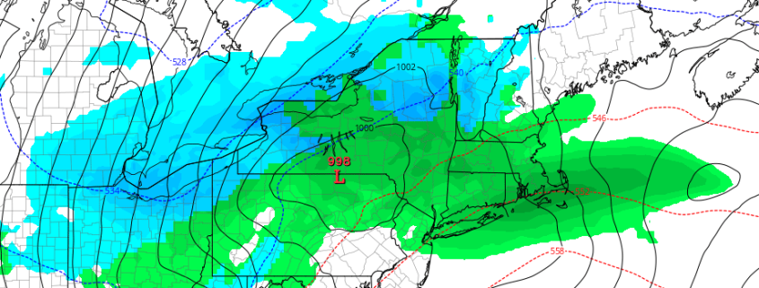
This weekend, we will once again revisit the science behind a back door cold front. A significant low pressure system is developing through the Central United States today, with the severe weather likely from the Plains into the Mississippi Valley and Southeast states. Meteorology tells us that a warm front should be surging north from the Mid Atlantic states into New England as this low pressure moves towards the Great Lakes, with southerly winds ramping up warm air south of the front. But forecast models suggest the front will only progress so far before it begins a dramatic retreat back south. Why? The answer lies in the setup both aloft and at the surface, and it leads to the development of a backdoor front which will push the warm air back to our south late Saturday into Sunday.
https://www.nymetroweather.com/wp-content/uploads/2018/04/3kmNAMcroppedtempsz.png731939John Homenukhttps://www.nymetroweather.com/wp-content/uploads/2024/02/Empire-2000-x-300-px-2.pngJohn Homenuk2018-04-13 19:12:222018-04-13 19:12:22Backdoor cold front season is here, what’s the deal?
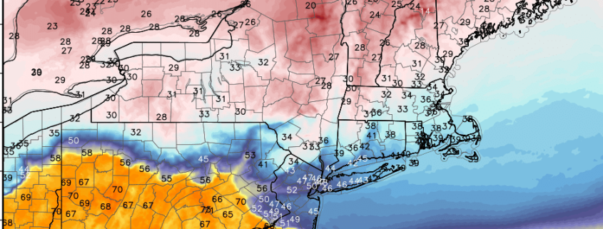
Good morning! We come bearing good news. Temperatures will begin moderating closer to seasonable levels over the next couple of days, which will lead us to very warm temperatures on Friday and Saturday. High temperatures may approach 80 degrees in many areas for the first time this year! By Sunday, however, much cooler air is likely to return, as a backdoor cold front moves to the south from New England. Another large storm system threatens to bring the region heavy rainfall by Sunday night and Monday.
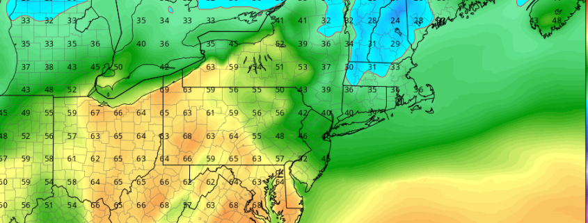
Forecast models have come into agreement on a pattern evolution that will support Spring-like weather throughout the Eastern part of the United States later this week and into this weekend, as a strong storm system develops in the Northern Plains states and then ejects northeastward towards the Great Lakes. A frontal boundary will shift eastwards into the Plains and eventually the Mississippi River Valley, but the amplified storm to our west will draw in Southerly winds and bring warm, moist air northward.
It won’t come without the need for some patience, as the beginning of this week has already started off very cold. Temperatures are well below seasonal averages and will remain there for the next few days with a cold high pressure overhead. A weak disturbance shifting by on Tuesday may even prove sufficient to produce rain and snow showers across the region – with snow particularly possible in the interior and higher elevations of New Jersey, Pennsylvania, and New York.
https://www.nymetroweather.com/wp-content/uploads/2018/04/gfs2tmfeature.png577926John Homenukhttps://www.nymetroweather.com/wp-content/uploads/2024/02/Empire-2000-x-300-px-2.pngJohn Homenuk2018-04-09 08:13:282018-05-01 12:39:20Spring weather finally on the way later this week
Hi friends! Our website uses cookies to provide an optimal browsing experience for you. New "Cookie Consent" laws mandate us to inform you of this. As long as you're cool with it, just hit OK. You'll only see this message once.
We may request cookies to be set on your device. We use cookies to let us know when you visit our websites, how you interact with us, to enrich your user experience, and to customize your relationship with our website.
Click on the different category headings to find out more. You can also change some of your preferences. Note that blocking some types of cookies may impact your experience on our websites and the services we are able to offer.
Essential Website Cookies
These cookies are strictly necessary to provide you with services available through our website and to use some of its features.
Because these cookies are strictly necessary to deliver the website, refusing them will have impact how our site functions. You always can block or delete cookies by changing your browser settings and force blocking all cookies on this website. But this will always prompt you to accept/refuse cookies when revisiting our site.
We fully respect if you want to refuse cookies but to avoid asking you again and again kindly allow us to store a cookie for that. You are free to opt out any time or opt in for other cookies to get a better experience. If you refuse cookies we will remove all set cookies in our domain.
We provide you with a list of stored cookies on your computer in our domain so you can check what we stored. Due to security reasons we are not able to show or modify cookies from other domains. You can check these in your browser security settings.
Other external services
We also use different external services like Google Webfonts, Google Maps, and external Video providers. Since these providers may collect personal data like your IP address we allow you to block them here. Please be aware that this might heavily reduce the functionality and appearance of our site. Changes will take effect once you reload the page.
-2")